Devpost
Participate in our public hackathons
Devpost for Teams
Access your company's private hackathons
Grow your developer ecosystem and promote your platform
Drive innovation, collaboration, and retention within your organization
By use case
Blog
Insights into hackathon planning and participation
Customer stories
Inspiration from peers and other industry leaders
Planning guides
Best practices for planning online and in-person hackathons
Webinars & events
Upcoming events and on-demand recordings
Help desk
Common questions and support documentation
Product engineer for ArcGIS Runtime SDK for .NET at Esri
CareLink offers a comprehensive helpline solution designed to help unhoused people find nearby resources such as shelter, legal aid, mental health care and food kitchens.
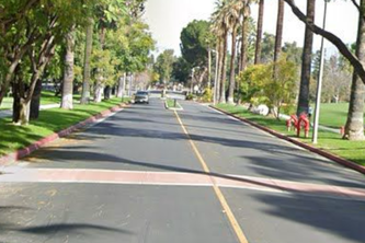
Experience, how a location looked like in the past!!! Create a community that can share their experiences, in AR
Revolutionizing Parking Solutions
EasyAisle maximizes efficiency and profit of grocery delivery drivers by collecting orders from multiple platforms, creating an aggregate grocery list, and guiding the user through an optimal route.
Use our android based AR-game TrEsri Hunt, powered by ArcGIS Online map to spot all the Globies hidden in Building L at Esri campus using the clues.
Where donors meet donation centers.
Forward is a website that gives information on women's reproductive healthcare access across the country. Features in the website include a clinic locator, transportation guide, resources, and more.
The pandemic changed how we live, work and play. With Street Smart, powered by ESRI's newly released GeoAnalytics Engine, take back control with near real time mobility data.
Find your path to safety.
Find your next coffee and learn about it's story.
A dashboard depicting AIS-tracked marine vessels merged with satellite data on SAR-identified ones in order to spot unregulated, i.e. 'dark,' vessels along regions on the U.S coastline.
Our project seeks to provide an analysis of the location-based risks facing currently monitored Grus Grus on a variety of environmental factors.
Using the ArcGIS Maps SDK for Unity, our team set out to make a Virtual Reality Biking Simulator, that allows the user to experience biking outdoors, while staying in the comfort of your own home.
We built an app to aid in tracking animals with the help of a region’s public. Users capture the animals they find, and the app uses deep learning to ID the animal and drop a point to a community map.
Crazy for Green Space! Enhancing the planning & distribution of green spaces in urban areas to optimize health, recreation, & education benefits. Coming soon to your app stores: Green Space Optimizer.
Utilizing ArcGIS Pro, machine learning spatial analyst tools, historic climate-related damages & climate data, we can predict future FEMA Risk Indexes based on climate model projections.
An easy-to-use sunscreen reminder that takes into account the user’s location, activity, and the last time they applied sunscreen in order to give them reapplication alerts.
Using GIS and Software Development to improve access to bike transit in Washington DC
City farms are great, but where to start? Planners waste time and money searching for sites. But now there's Truss - a site suitability app that locates vacant city parcels for potential urban farms.
VaxFinder helps people locate vaccination clinics quickly and effectively. Users are able to simply text a phone number, then we respond with the best possible location and route.
California: home to Esri, but also home to some of the worst air quality in the country. Our Android app empowers users to see what others can't through realtime data and visualizations of pollutants.
Where is your music from? Put your playlist to the test.
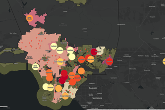
Using AQI, Asthma, and Hospital location data, we are able to identify high risk areas for air pollution related illnesses.
The Reward to Explore! With a GeoBlockchain enabled Trails and Routes App, those who enjoy hiking now have an opportunity to earn rewards towards their next outdoor adventure.