-
-
-

Processing SAR imagery using ModelBuilder

Inspiration
Marine traffic encapsulates vessels of various types that are involved in different activities of commercial and military kind. In order to enforce maritime security and accountability, the government employs an Automatic Identification System (AIS), or an automated tracking system that displays other vessels in the vicinity by using transponders. Since this activity is continuously monitored and regulated, it poses a hindrance for individuals and organizations looking to circumvent the law to carry out dealings or activities on the illegal side without being openly detected.
Dark Vessels are vessels that turn off their AIS transponders or cooperative beacons in order to evade authorities. For example, illegal fishing is a great threat to the economy, environment and security for regions it takes place around, and exposes a big hole in terms of administrative or actionable efforts.
However, if they still have their S-band or X-band marine radar on, Synthetic Aperture Radar (SAR) data can be used to enhance existing AIS services and enable reliable detection from satellites. The team was able to recognize the importance of addressing this space to help contribute towards strengthening monitoring efforts by the United States Coast Guard and built a dashboard that allows the user to view the position and presence of AIS-tracked and SAR-tracked vessels in given regions along coastal waters, and identify dark vessels by taking note of discrepancies within data from the two sources in a manner that is visually easy to comprehend.
What It Does
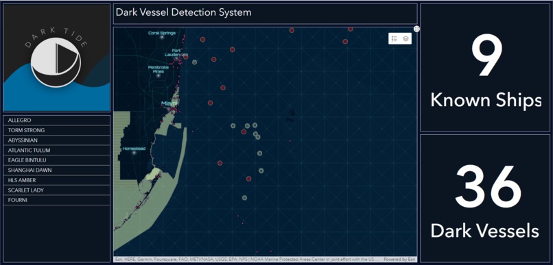
DarkTide is a dashboard that displays ships sailing in waters around North America and gives users insight on the number of those ships that are "Known" and tracked by the US Coast Guard and the number of ships that are "Dark Vessels", which switch off their location-transmitting devices. Users can zoom and scroll to explore areas with high shipping activity, such as the waters around South Florida and the Bahamas. The color-coordinated ships indicate if the ship is known or dark and users can apply layers to identify if the ship is sailing on a NOAA-protected "No-take" zone. The dashboard can also display a list of all the ships in a specified region and provides an overall count of the total number of dark and known ships operating at that time.
DarkTide is a valuable tool for maritime regulation agencies. Often, to mask activities such as illegal fishing and drug and human trafficking, ships will turn off their AIS tracking systems and go "dark". In DarkTide's current version, agencies such as the Coast Guard can precisely locate regions with high dark vessel activity and monitor these regions more carefully. Together, we can significantly reduce the number of dark vessels.
How We Built It
To get started with the project, we have divided the task as follows:
1. Retrieving Data: **
**SAR imagery: Copernicus Open Access Hub
a. Mission: Sentinel-1
b. Satellite Platform: S1A_*
c. Product Type: GRD (Ground Range Detected)
d. Polarization: VV (co-polarization)
e. Sensor Mode: IW (Interferometric Wide swath)
AIS (Automatic Identification System) Vessel Tracking Data: Marine Cadaster
NOAA’s Marine Protected Areas Inventory: Living Atlas
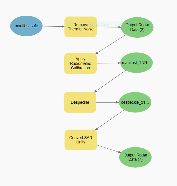
2. Processing SAR Imagery:
Building model in ArcGIS Pro 3.0 to process SAR images
SAR is powerful, as it can provide high quality imagery through inclement weather. It is also challenging to process and requires various steps to make it useable for analysis. ArcGIS Pro 3.0 provides increased functionality and tools for processing this data and we created our model based on the model suggested in this ArcGIS Pro Help page.
Importing Deep Learning Libraries to ArcGIS Pro 3.0.
This was a crucial step in allowing the following deep learning model to run.
Running deep learning model: “Detect Ships using SAR data”
This ArcGIS Pro 3.0 tool detects ships after the SAR data is processed.
Quality checking the detected ships
Naturally, deep learning is not 100% accurate, so we followed the analysis with manual detection of ships. With very clear imagery, it is obvious where a ship is in the water, making this step simple.
3. Processing AIS Data: Understanding the metadata of AIS data and cleaning up the CSV to filter data according to specified time range. ArcGIS Notebook Server was being used for all analysis to be done on AIS data
4. Performing Spatial Join between SAR Detected Ships and ships sending AIS Signal using ArcGIS Pro. This helps to identify several Dark vessels off the East coast of Florida.
5. Export the above results as a Web Layer for use in ArcGIS Online
6. Configure ArcGIS Dashboard for visualizing and summarizing ship information.
Challenges We Ran Into
- Documentation for a few of the packages we wanted to use was not very specific so we tried do it in ArcGIS 2.9 but it did not work so we had to switch to 3.0
- We had difficulty integrating different ArcGIS services
Accomplishments That We're Proud Of
We took on the challenge to work with data sources and types that most of us had no prior experience in. We are very proud of the work that went into processing SAR data, which paid off in the end. Ultimately, we built a dashboard that functions to a great extent in the way we hoped for it to by processing new forms of data in order to provide information that is very important and necessary within the context of our space.
What We Learned
- How to go from raw SAR imagery to a processed version that can be used by the Detect Object tool in ArcGIS Pro
- AIS (automatic identification system), used to identify and track ships is publicly available information
- Learned how to use API's like SAR Ship Detection
What's Next for DarkTide Dark Vessel Detection
Given unlimited resources and more time, the team would have liked to make the dashboard functional for real-time data over a larger extent of the map. We could have explored the addition of more attributes for individual vessels and tried to build out a more accurate detection model for identifying vessels collected through the data sources. A deeper focus might be to incorporate data about essential fish habitats that are protected from fishing in order to target the illegal fishing problem.
More immediately, we look forward to hearing the feedback our judges have for us and taking note of our strengths and weaknesses across the project execution.


Log in or sign up for Devpost to join the conversation.