Devpost
Participate in our public hackathons
Devpost for Teams
Access your company's private hackathons
Grow your developer ecosystem and promote your platform
Drive innovation, collaboration, and retention within your organization
By use case
Blog
Insights into hackathon planning and participation
Customer stories
Inspiration from peers and other industry leaders
Planning guides
Best practices for planning online and in-person hackathons
Webinars & events
Upcoming events and on-demand recordings
Help desk
Common questions and support documentation
Sort by:
Aura - Accessible Urban Route Assistant - a mapping system for people with specific needs.
Blood Warriors: Making blood donation social, smart, and life-saving through community-powered healthcare.
Zindagi Ke Liye , Ek Sahi Connection
Donation Center Finder
CarbonFlow: Where Captured Carbon Becomes Capital.
AgeWell helps caregivers remotely monitor and support seniors, especially those with Alzheimer's or Dementia, ensuring their safety and well-being at all times
“Appetizing business zones, mapped by taste to location.”
it's an interactive web page that shows the map of Sudan and some major cities that use renewable data to determine the safety or danger of the city The importance of it to determinethe more save eara
Saned empowers every citizen in Sudan to be a first responder. Report local emergencies via a simple interface and a live map, creating a vital, low-cost network for national safety.
دوائي منصة ذكية تسهّل العثور على الأدوية القريبة ومعرفة مواقعها فورًا، لحل مشكلة نقص وصعوبة إيجاد الأدوية في السودان
انضم إلى الآلاف الذين ساهموا بدمائهم في إنقاذ الأرواح.
Cultura Atlas is your passport to vibe-driven journeys—where your taste charts the map, not tourist traps
EcoLocal is a gamified web app that motivates urban users to adopt eco-friendly habits through daily challenges, points, badges, streaks, and local eco-spot discovery. Built for SDG 11. 🌍✨
"Harvest a Greener City—One Rooftop at a Time."
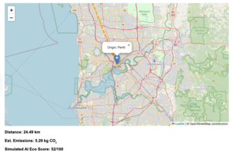
Empowering smarter, greener journeys with AI-driven eco-friendly route guidance — no API keys needed.
A proposal for a new, life-saving feature layer in Google Maps that allows citizens and city officials to collaboratively predict and prevent urban flooding.
AabPashi is a satellite- and AI-powered irrigation platform delivering real-time, hardware-free water insights to farmers, helping tackle water scarcity and climate challenges at scale.
CrisisNavigator is a real‑time disaster intelligence dashboard that fuses NASA, ReliefWeb, and GDACS feeds with AI analysis by Gemini to score severity and show the crises that need attention first.
Imagine having a personal real estate agent who knows every San Francisco neighborhood's crime patterns, energy costs, and hidden gems - that's Where2Liv!
A way to visualize Nusantara's Heritage
Walk the Culture, One Step at a Time
Feeding Hope, Not Landfills
AgroRithm uses AI, IoT, geofencing, SMS, BLE, computer vision and local voice AI to prevent farmer-herder clashes, reward eco-actions with tokens, and work offline via PWA app, USSD, Telegrambot etc