Devpost
Participate in our public hackathons
Devpost for Teams
Access your company's private hackathons
Grow your developer ecosystem and promote your platform
Drive innovation, collaboration, and retention within your organization
By use case
Blog
Insights into hackathon planning and participation
Customer stories
Inspiration from peers and other industry leaders
Planning guides
Best practices for planning online and in-person hackathons
Webinars & events
Upcoming events and on-demand recordings
Help desk
Common questions and support documentation
Sort by:
Buzz Board keeps you connected to your community by showing announcements within a 50-mile radius on an interactive map. Discover local events, create announcements, and engage like never before!
Leveraging AI to monitor police body cam footage, instantly flagging misconduct and allowing citizens to file complaints verified by the AI system that triggers swift escalation and accountability.
Parkinson’s affects millions worldwide, impairing movement and cognition. LOCUS, uses real-time data, AI, and geolocation to detect anomalies and quickly notify caregivers and emergency services.
This APP will help tourists learn about the places they are visiting. Instead of searching Google for multiple websites, this is a one-stop place.
The Fully Embedded Inertial Navigator, or F.E.I.N. for short, is an all terrain personal navigation system that is designed with you in mind, to keep you safe and on track.
Empower your sustainable travel journey—track your carbon savings, make eco-friendly travel choices, and contribute to a greener world.
Route Runner uses autonomous drones with augmented reality scanning to map disaster zones in real time and generate safe, efficient evacuation routes for both responders and the public.
The idea for In-Farmer arose to connect farmers, buyers, retailers, and consumers, addressing farmers' challenges in accessing direct markets and fair prices.
Trackonomy-powered app ensuring pet safety through location tracking and temperature monitoring.
A smart solution for elderly folks living alone that have the higher chance of having some kind of problem and no one to help them. Our SOS bracelet will allow them to call for help with one press.
Match your music to your car's speed! MusicDrive is an intelligent road trip music assistant with BPM-based app that streams songs from Deezer. Find the perfect driving rhythm!
Snap2Action is a platform that enables citizens to take charge of their surroundings by reporting local issues directly to district authorities, ensuring accountability and fostering impactful change
RideSafe: Smart Safety, Smarter Rides.
This project focuses on developing a reliable and efficient GPS tracking system using LoRa technology at the 433MHz frequency.
Detect. Protect. Connect. Use a wearable device to track whether a senior has fallen down, and connect them to their family members.
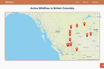
Stay informed and safe with WildCan, a wildfire tracking app designed for Canadians. WildCan provides real-time updates and alerts about wildfires near you, ensuring you’re always safe!
FarmVision: Transform invisible farm sensor data into an interactive 3D AR environment, seamlessly switching between mobile and spatial views for intuitive agricultural monitoring.
"MargaDarshak: Navigational Goggles that Transform Echoes into a Guiding Light – Helping the Blind See Through Sound."
LoRaFence: Revolutionizing animal tracking and virtual fencing with smart geofencing and stimuli feedback empowering conservation with precision and care.
AidNet is a real-time emergency response system designed to bridge the gap between dispatchers and first responders. By leveraging cutting-edge technology.
A revolutionary button-sized device that transforms personal safety, providing instant location tracking and emergency alerts with a single press, empowering women and children safety.
CardioAlert is a smart band that monitors heart rate, detects abnormalities, and sends GPS-based emergency alerts to contacts and services, ensuring faster response and saving lives.