-
-
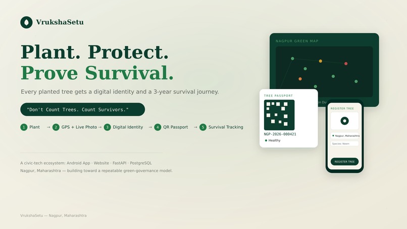
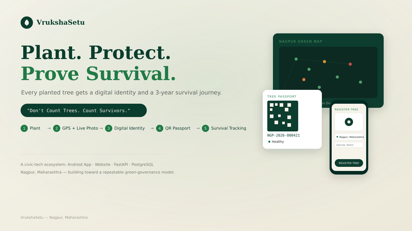
VrukshaSetu connects a physical tree to a digital identity and long-term survival journey.
-
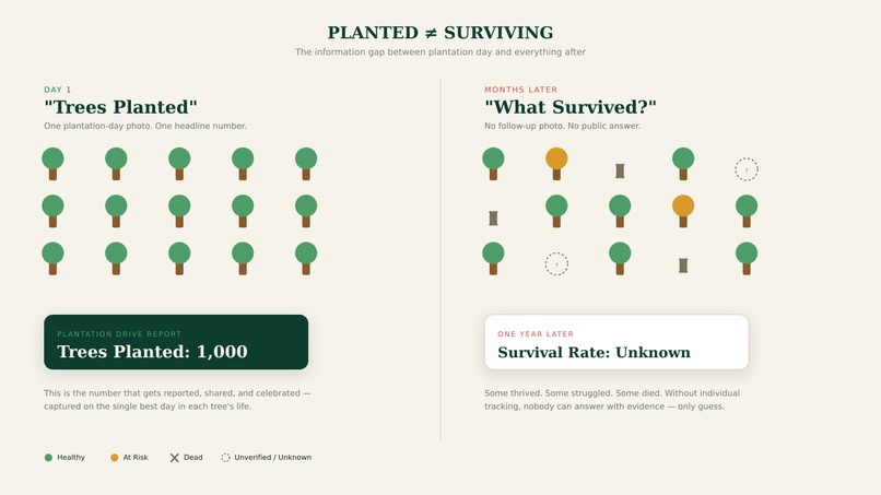
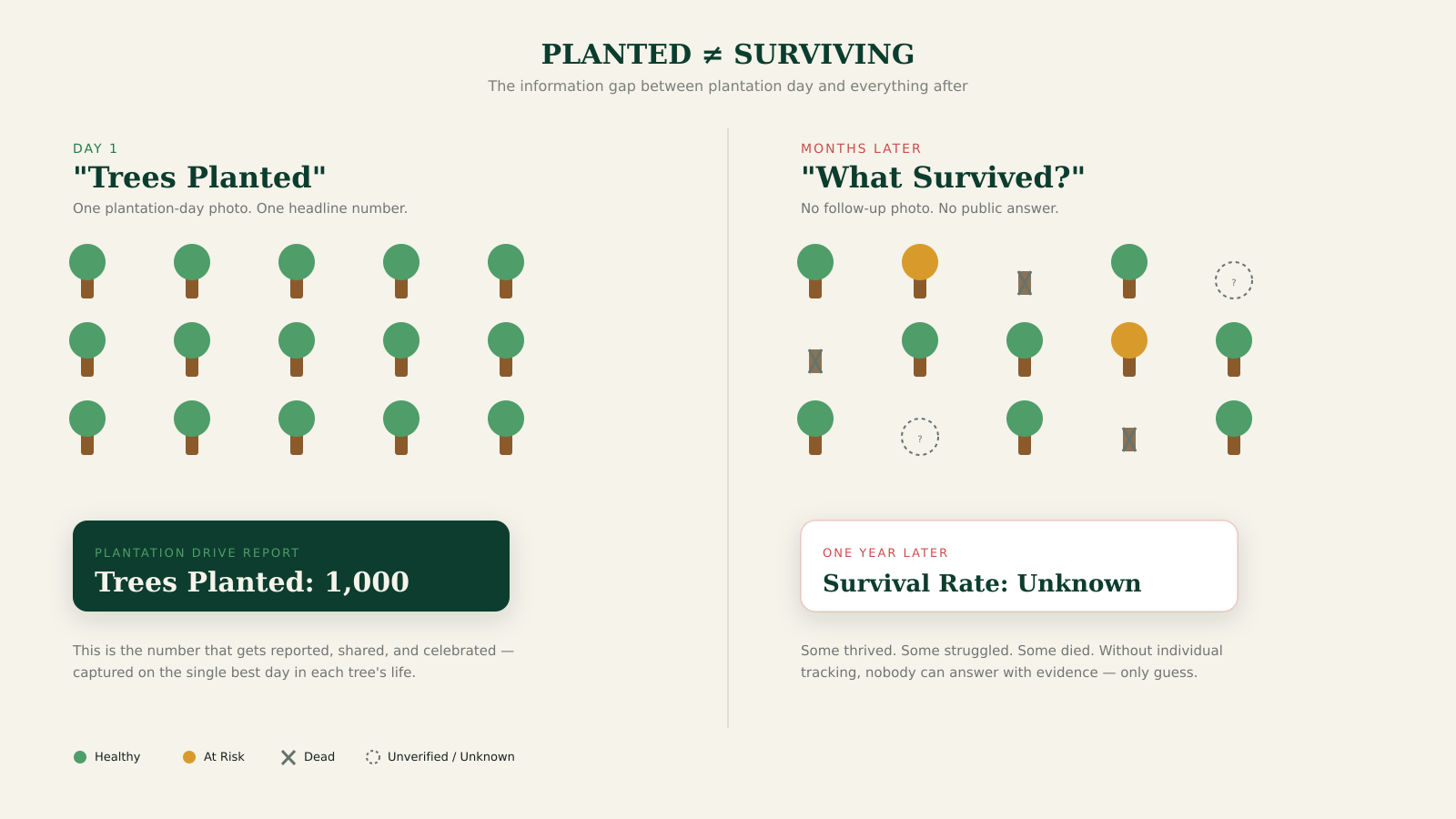
Plantation numbers tell us what happened on Day 1. Survival tells us what happened afterward.
-
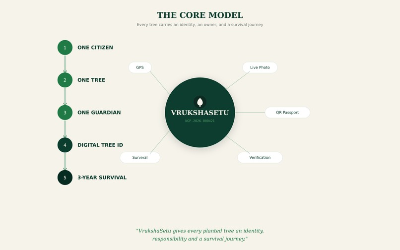
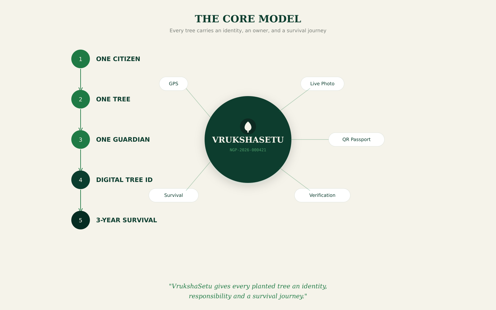
VrukshaSetu gives every planted tree an identity, responsibility and a survival journey.
-
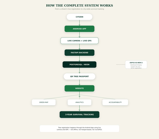
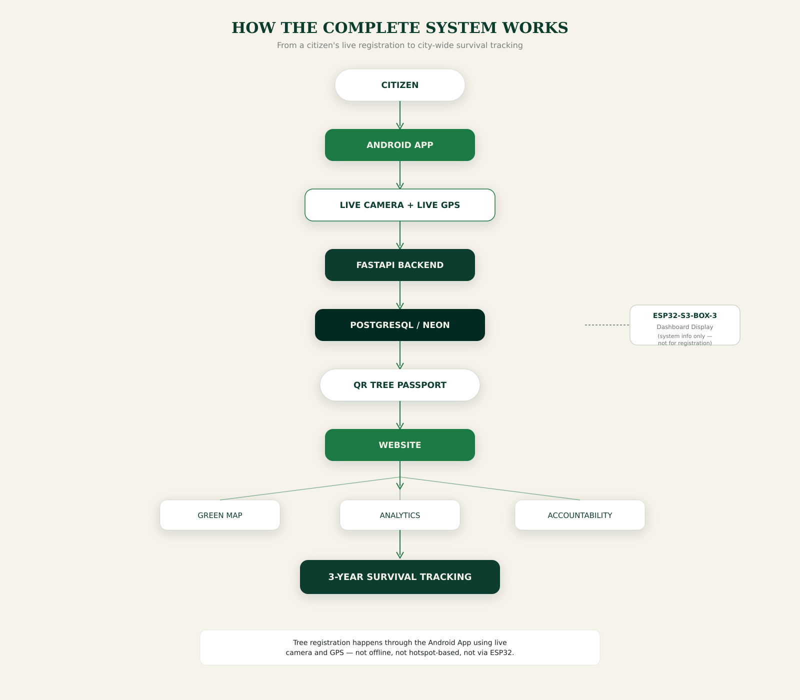
One connected ecosystem links field registration, tree identity, monitoring and long-term survival.
-
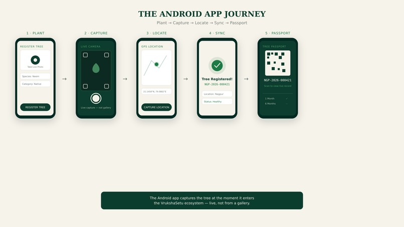
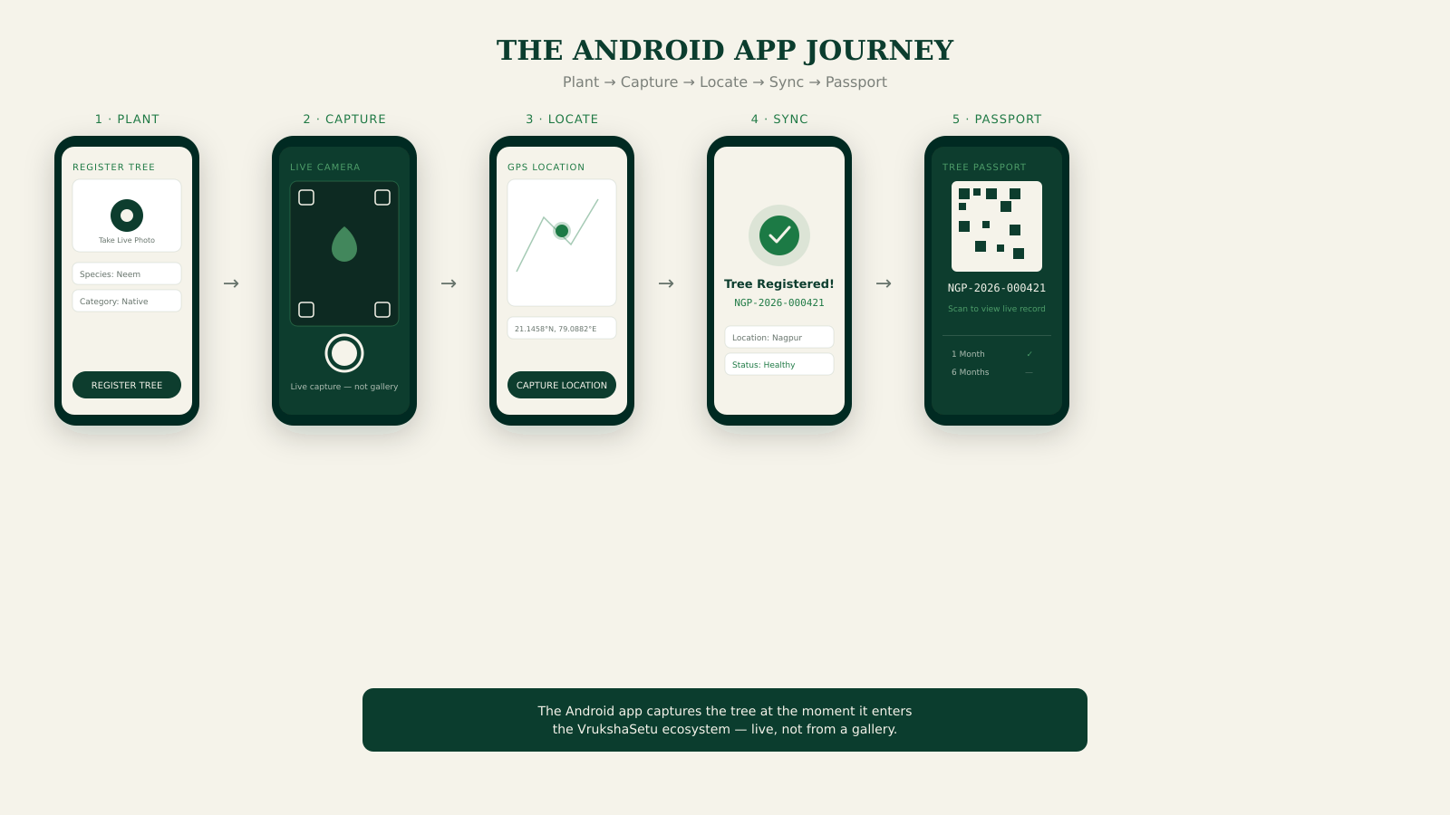
The Android app captures the tree at the moment it enters the VrukshaSetu ecosystem.
-
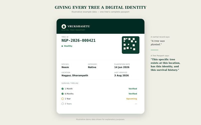
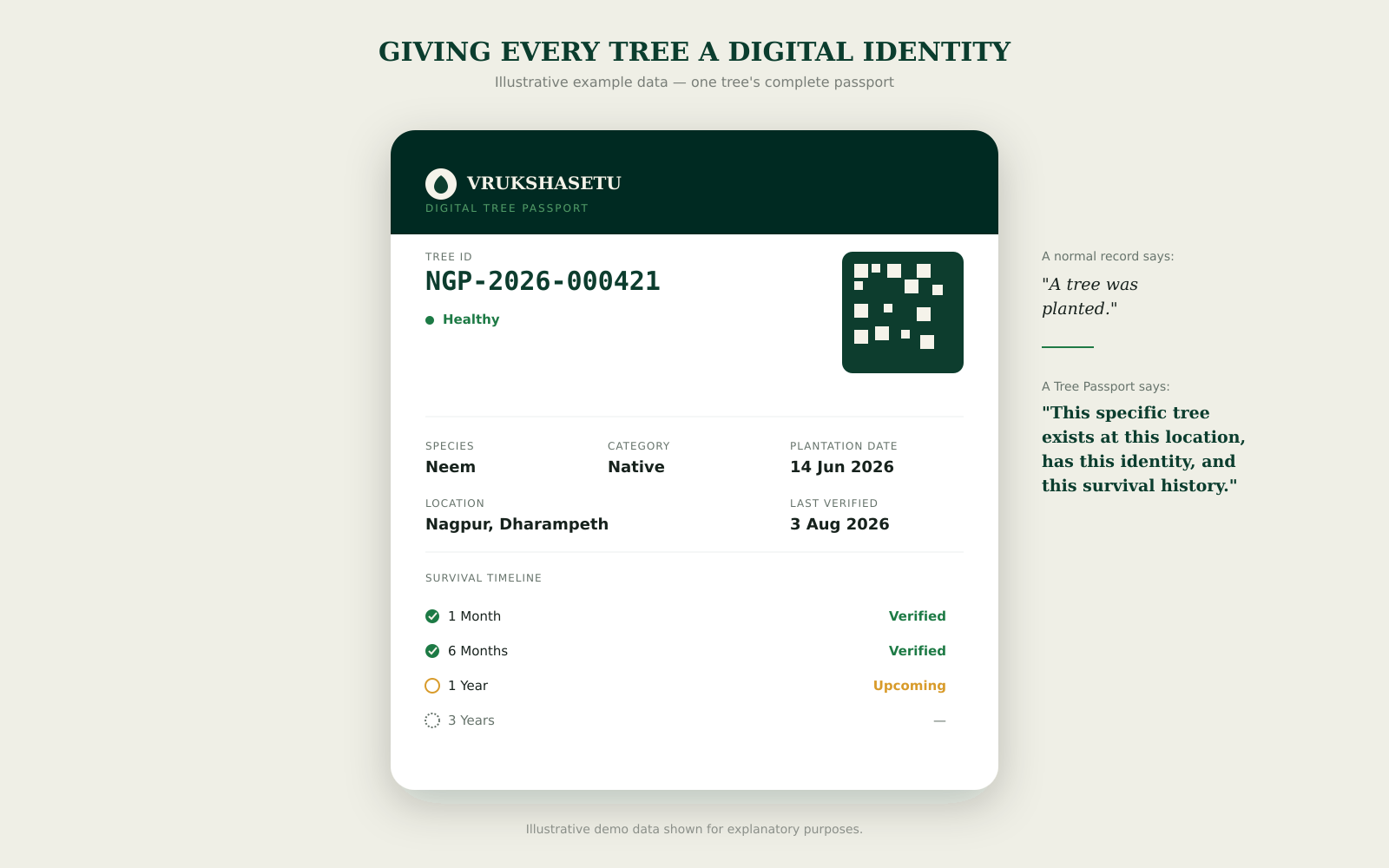
A QR-enabled digital passport turns an individual tree into a trackable digital record.
-
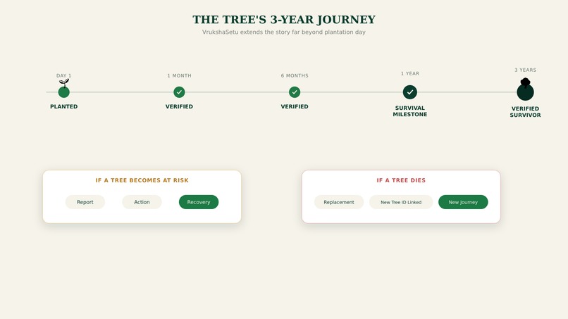
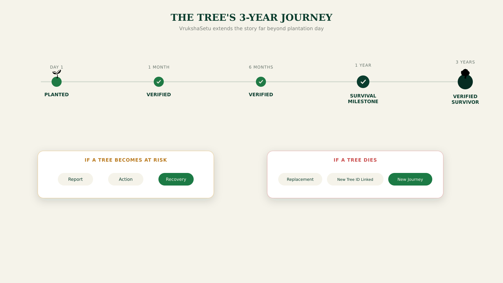
VrukshaSetu extends the tree's story far beyond plantation day.
-
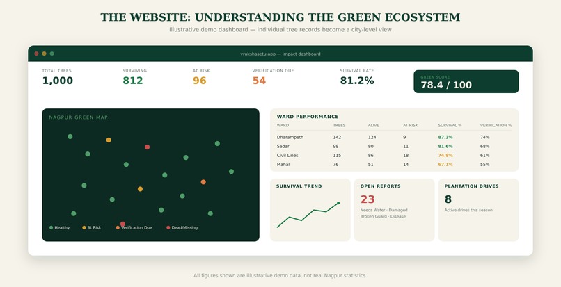
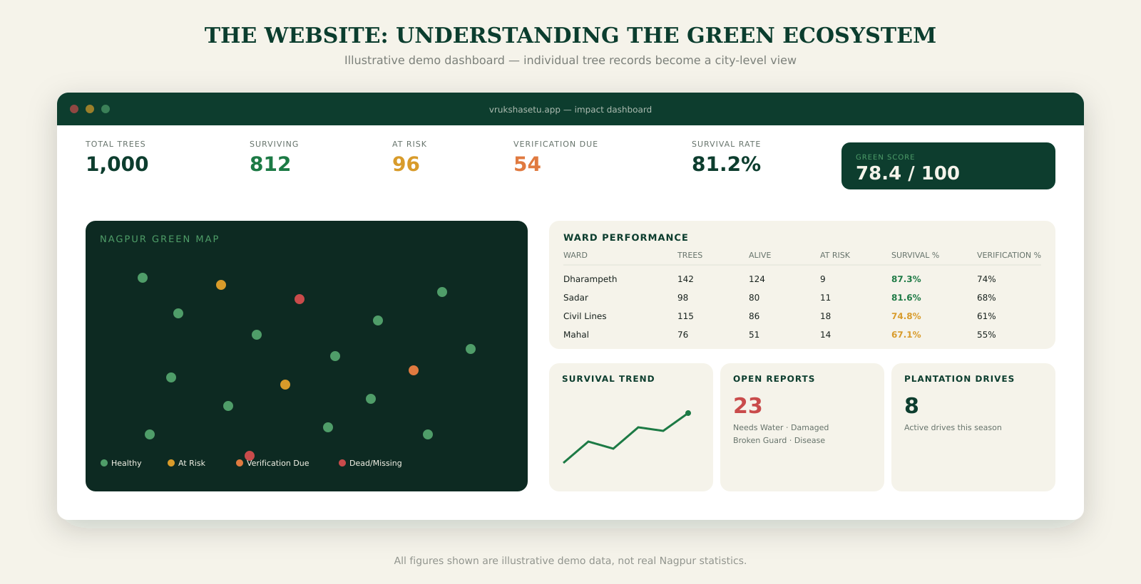
The website turns individual tree records into a city-level view of the green ecosystem.
-
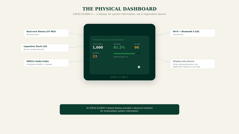
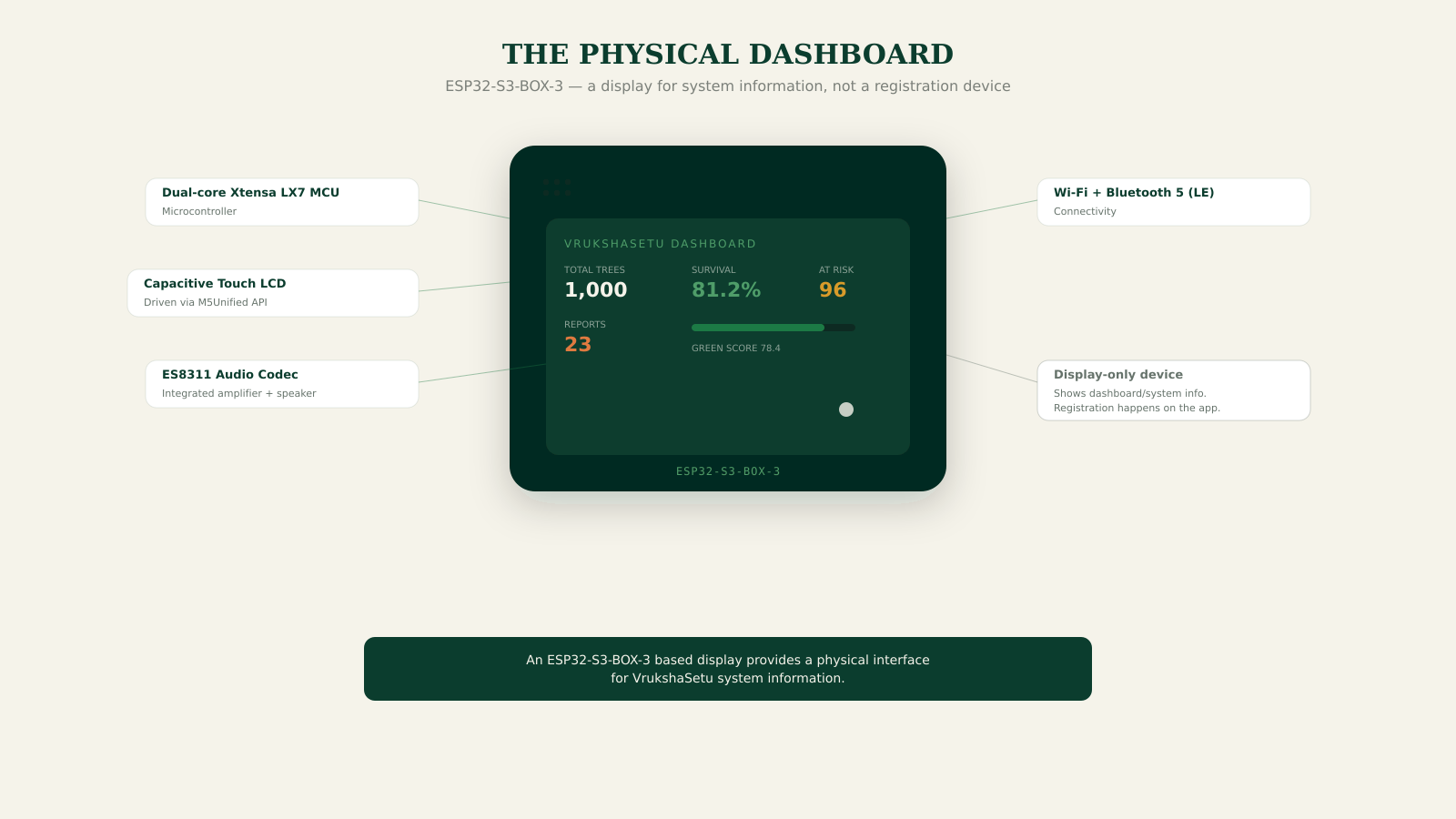
An ESP32-S3-BOX-3 based display provides a physical interface for VrukshaSetu system information.
🌳 VrukshaSetu —
Inspiration
Every year, thousands of trees are planted through government, institutional, community, and individual plantation drives. But one question often remains unanswered:
How many of those trees are actually alive after one year, three years, or longer?
We realized that planting a tree is only the beginning. Once the plantation drive is over, tracking the tree's exact location, health, responsibility, and long-term survival becomes difficult.
This inspired us to build VrukshaSetu — a digital ecosystem that gives every planted tree an identity and a measurable survival journey.
Our core idea is:
One Citizen → One Tree → One Guardian → 3-Year Verified Survival
Instead of measuring environmental success only by the number of trees planted, VrukshaSetu focuses on verified tree survival.
Our vision is to start with Nagpur and create a model that can eventually be replicated across cities and states in India.
What it does
VrukshaSetu connects tree plantation, digital identity, location, verification, accountability, and long-term survival tracking into one platform.
📱 Android App — Field Layer
The Android application is used when a citizen plants a tree.
The registration process captures:
- Live camera photo
- Live GPS location
- Tree species
- Tree category
- Plantation information
After registration, the system generates a unique Tree ID and QR Digital Tree Passport.
For example:
NGP-2026-000421
The QR Passport provides a digital identity for that particular tree.
🔖 Digital Tree Passport
Every tree can have its own digital record containing:
- Tree ID
- Species
- Category
- Plantation date
- Location
- Current status
- Last verification
- Survival timeline
- QR identity
This changes the concept from:
"We planted 10,000 trees."
to:
"Here are the individual trees, where they are, who is responsible, and how many are surviving."
🗺️ Nagpur Green Map
The website provides an interactive Green Map where registered trees can be visualized according to their status.
For example:
🟢 Healthy 🟡 At Risk 🟠 Verification Due 🔴 Dead/Missing
Users can explore trees using filters such as ward, species, category, and plantation drive.
📊 Monitoring & Analytics
VrukshaSetu provides dashboards for monitoring:
- Total trees
- Surviving trees
- At-risk trees
- Dead/missing trees
- Verification status
- Ward-wise performance
- Species and category distribution
- Survival trends
- Plantation drives
🚨 Accountability & Reporting
Citizens and responsible organizations can report problems such as:
- Dead trees
- Missing trees
- Damage
- Lack of watering
- Broken tree guards
- Disease
- Other maintenance issues
Issues can then be tracked through an accountability flow involving guardians, institutions, NGOs, and authorities.
♻️ Replacement Tracking
If a registered tree dies, VrukshaSetu can maintain a connection between the original tree and its replacement.
For example:
NGP-2026-000421
↓
Replacement: NGP-2026-000421-R1
This ensures that failed plantations don't simply disappear from the system.
🌱 3-Year Survival Tracking
The system focuses on important survival checkpoints:
1 Month → 6 Months → 1 Year → 3 Years
Our key impact metric is:
Verified 3-Year Tree Survival Rate
How we built it
VrukshaSetu is built as a connected ecosystem consisting of an Android application, web platform, backend, database, and monitoring hardware.
📱 Android Application
The Android app is the primary field interface.
It handles:
Plant Tree → Live Camera → Live GPS → Registration → Live Sync → QR Passport
Gradle is used as part of the Android development stack.
🌐 Website
The VrukshaSetu website acts as the public and governance layer.
It provides:
- Nagpur Green Map
- Tree Passport
- Tree Registry
- Green Score
- Survival Analytics
- Ward Dashboard
- Plantation Drives
- College Green League
- Reports
- Accountability
- Admin/Authority Dashboard
The website is built using Next.js.
⚡ Backend
We use FastAPI as the central API layer connecting the Android application, website, and database.
The backend handles:
- Tree registration
- User information
- GPS data
- Verification records
- Tree status
- Reports
- Analytics
- QR identity
- Accountability
- Replacement tracking
🗄️ Database
We use PostgreSQL hosted on Neon to store the structured tree and platform data.
🔖 QR Digital Identity
Each registered tree receives a unique QR identity that can connect users to its digital Tree Passport.
🗺️ Mapping
The Green Map uses interactive mapping to visualize tree locations and statuses.
🔌 Hardware Dashboard
We also developed a physical dashboard concept using:
ESP32-S3-BOX-3
with:
- Dual-core Xtensa® LX7 MCU
- Capacitive Touch LCD
- M5Unified API
- ES8311 Audio Codec
- Integrated amplifier and speaker
- Wi-Fi
- Bluetooth 5 (LE)
The hardware is primarily used to display VrukshaSetu dashboard/system information.
It is not the primary tree registration mechanism; registration happens through the Android app using live camera and GPS.
Challenges we ran into
Building VrukshaSetu involved several challenges.
1. Moving beyond plantation counts
The biggest conceptual challenge was deciding what should actually be measured.
Instead of simply tracking:
Trees Planted
we designed the system around:
Trees Surviving
This required designing a longer lifecycle for every tree.
2. Live evidence collection
Tree registration needs trustworthy evidence.
We therefore designed the registration process around:
Live Camera + Live GPS
instead of relying only on manually entered information.
3. Long-term accountability
Planting a tree is easy compared with maintaining it for years.
We had to think about how responsibility could continue after the plantation event through:
- Guardians
- Verification
- Reporting
- Escalation
- Replacement tracking
4. Connecting multiple platforms
VrukshaSetu involves an Android app, website, backend, database, QR system, map, and hardware dashboard.
Keeping these components connected through a common backend and consistent tree identity was an important engineering challenge.
5. Making environmental data understandable
Environmental monitoring can easily become a collection of complicated dashboards.
We focused on making the information understandable through:
- Green Map
- Tree Passport
- Survival Timeline
- Green Score
- Ward Analytics
- Simple status indicators
Accomplishments that we're proud of
🌳 1. We changed the metric
Our biggest accomplishment is the shift from:
"How many trees did we plant?"
to:
"How many trees survived?"
🔖 2. Digital identity for every tree
The QR-based Tree Passport gives each tree a unique digital identity rather than treating a plantation drive as one large number.
📍 3. Live location + evidence
Tree registration combines live camera evidence with GPS, creating a stronger connection between the digital record and the physical tree.
🗺️ 4. City-level visualization
The Green Map allows the entire tree ecosystem to be visualized spatially, making individual trees and their status easier to understand.
📊 5. End-to-end monitoring concept
We designed the complete journey:
Plant → Register → Identify → Verify → Monitor → Report → Escalate → Replace → Track Survival
🇮🇳 6. Scalable model
Although our initial focus is Nagpur, the architecture is designed around a model that can be adapted to other cities, institutions, NGOs, and plantation programs.
What we learned
One of our biggest learnings was that technology alone does not solve an environmental problem.
A successful environmental system needs three things:
Technology
To collect, connect, and visualize reliable information.
People
To take responsibility for the trees after plantation.
Continuous Monitoring
To ensure that environmental impact is measured over time.
We also learned that simple user experiences are extremely important.
A citizen should not need technical knowledge to register or understand a tree. That's why we designed the core experience around a simple flow:
Plant → Capture → Locate → Sync → Passport → Protect
Most importantly, we learned that environmental impact should be measured by outcomes rather than activities.
Planting is an activity.
Survival is an outcome.
What's next for VrukshaSetu
Our next goal is to move from a prototype into a real-world pilot.
🌱 1. Nagpur Pilot
We want to begin with a limited plantation area such as:
- College campuses
- Ward-level plantation drives
- Community spaces
and register real trees through VrukshaSetu.
📈 2. Real Survival Data
As trees continue through their survival timeline, we want to build a real dataset around:
- Survival
- Species performance
- Location
- Maintenance
- Seasonal patterns
- Verification
This can help organizations understand what actually works in urban plantation programs.
🏫 3. College & Community Network
We want to involve colleges, students, NGOs, and communities as Tree Guardians and create survival-focused green initiatives.
🏛️ 4. Institutional Adoption
The long-term goal is to make VrukshaSetu useful for organizations conducting plantation programs by providing transparent monitoring and impact reporting.
🇮🇳 5. Nagpur → India
Our larger vision is:
Start in Nagpur. Build a repeatable model. Scale it across India.
Different cities could use the same core system while maintaining their own wards, plantation drives, tree populations, and environmental dashboards.
🌳 Our Vision
Planting a tree takes a moment. Protecting it takes responsibility. Proving its survival creates impact.
VrukshaSetu
Don't Count Trees. Count Survivors.
Built With
- android
- esp32-s3-box-3
- fastapi
- gps
- gradle
- kotlin
- leaflet.js
- live-camera
- m5unified
- neon
- next.js
- openstreetmap
- postgresql
- python
- qr-code
- recharts
- wi-fi


Log in or sign up for Devpost to join the conversation.