-
-

UrbanPilot Logo
-
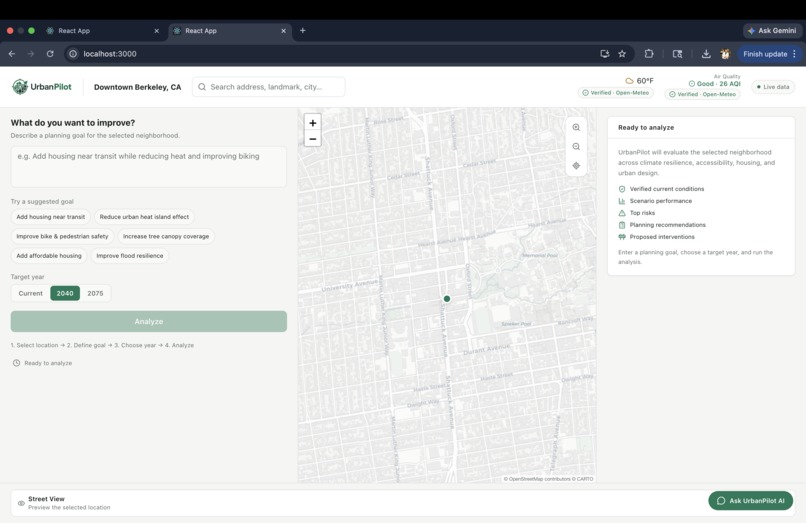
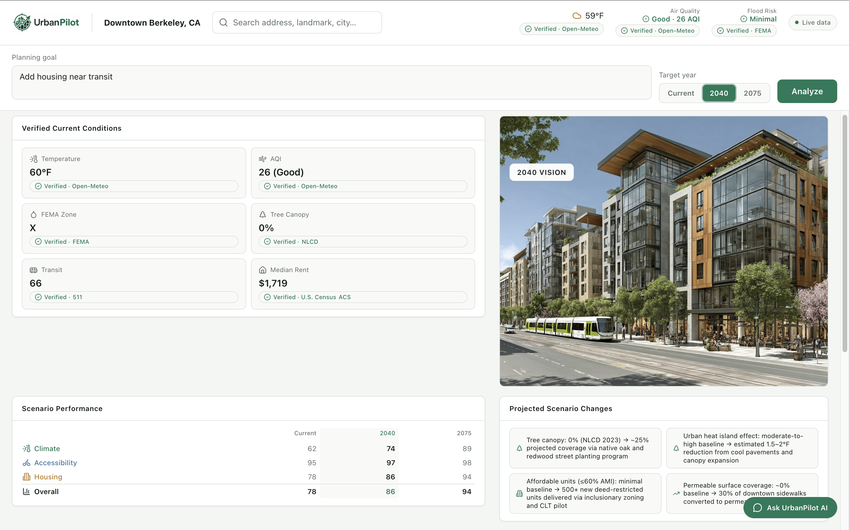
Pre Analysis Page
-
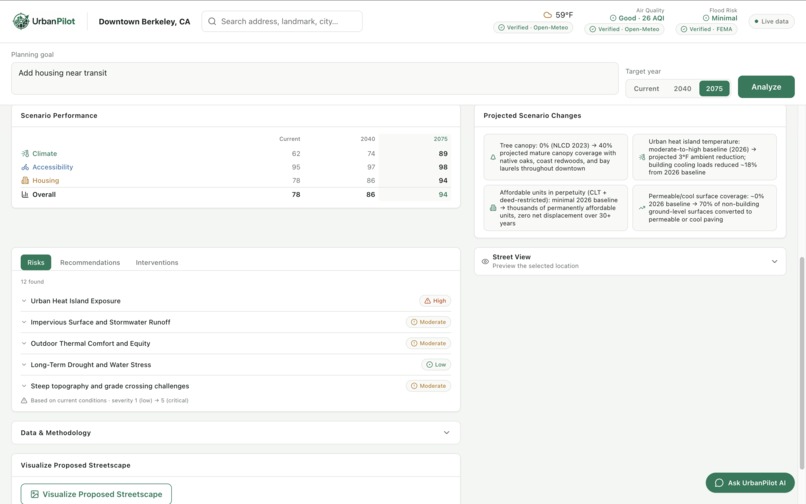
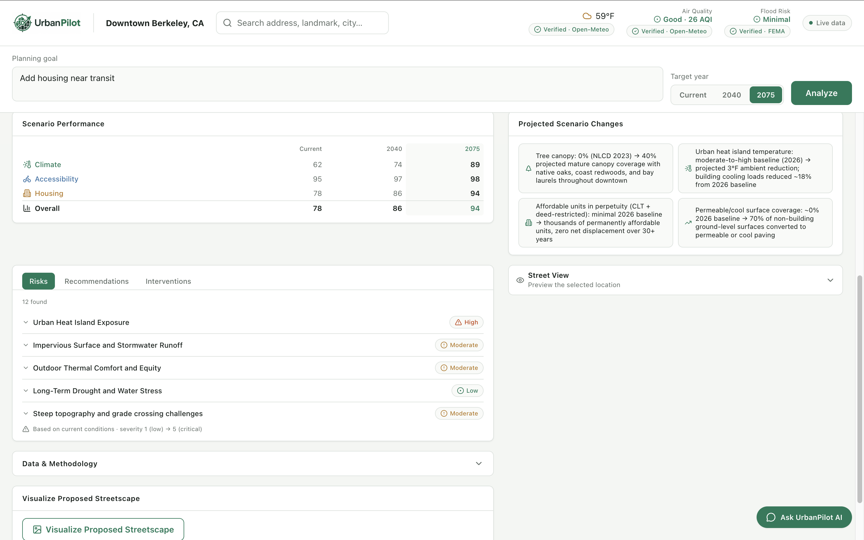
Analysis Page
-
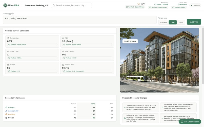
Visualize Proposed Streetscape

Inspiration
Cities are changing faster than ever due to climate change, housing shortages, rising temperatures, flooding, and shifting transportation needs. Yet most residents, planners, and policymakers struggle to access planning data because it is scattered across dozens of government websites, reports, and GIS platforms. As students interested in urban planning, data science, design, and artificial intelligence, we wanted to create a tool that makes complex planning information understandable for everyone. We asked a simple question:
What if anyone could enter an address and instantly understand both its current conditions and its future risks?
UrbanPilot was built to bridge the gap between public data and public understanding.
What it does
UrbanPilot analyzes any address and combines real public planning data with specialized AI agents to explain current conditions, identify risks, and visualize how a neighborhood could evolve by 2040 and 2075. Unlike traditional planning tools, UrbanPilot grounds its analysis in verified public datasets including Census, FEMA, GTFS transit, NLCD tree canopy, and Open-Meteo environmental data, while clearly distinguishing between measured data and AI-generated projections.
The platform evaluates:
- Climate risk
- Flood risk
- Heat vulnerability
- Housing conditions
- Accessibility and transit access
- Environmental factors
- Community resilience indicators
Each address gets one overall score, averaged only from the categories with valid data:
$$\text{Overall Score} = \frac{1}{n}\sum_{i \,\in\, {\text{climate, accessibility, housing}}} \text{Score}_i$$
Users can explore both current conditions and projected future scenarios for 2040 and 2075. The platform combines verified public datasets with AI-generated planning recommendations while clearly distinguishing between measured data and projected estimates.
UrbanPilot also generates AI-created future visualizations showing how neighborhoods may evolve under changing environmental conditions, helping users understand future impacts in a way that maps and spreadsheets cannot.
Finally, users can chat with UrbanPilot AI to ask planning-related questions and receive evidence-based recommendations grounded in verified planning data.
How we built it
We built UrbanPilot as a full-stack web application using:
- React for the frontend
- Node.js and Express for the backend
- Tailwind CSS and shadcn/ui for the frontend design system
- Leaflet + OpenStreetMap/CARTO for the interactive map (Google Maps is used server-side only, for Street View/satellite imagery and geocoding)
- Climate and flood risk datasets
- Specialized AI agents for housing, accessibility, climate, vision generation, and planning assistance
- Claude and Anthropic APIs for reasoning and recommendations
- Multi-agent workflows for data collection, analysis, and report generation
- Midjourney's MCP server for AI-generated future neighborhood visualizations
- Sentry for production error monitoring
- ACS Census 2024 5-Year estimates
- 511 SF Bay GTFS transit data
- FEMA National Flood Hazard Layer
- NLCD Tree Canopy Cover 2023
- Open-Meteo weather and air quality data
- The Token Company's prompt-compression SDK, layered on top of a custom-built compact prompt encoding, to reduce per-request token cost
The system combines five public datasets, geospatial analysis, and specialized AI agents into a single workflow that transforms a simple address into actionable planning insights.
We also treated token efficiency as a first-class engineering problem, not an afterthought. Every agent prompt that sends verified third-party data (Census, FEMA, NLCD, GTFS) to Claude was rewritten from a pretty-printed, human-readable format into a hand-built compact encoding — measured against real Anthropic API calls, this cut input tokens by 27.8–35.4% per agent with zero loss of output quality (every response still parsed as valid JSON and cited the exact verified figures). We then layered The Token Company's compression SDK on top of that in production, and benchmarked both independently: their generic compressor performs best on prose-heavy, unstructured prompts (20.6% reduction on our AI assistant's context), while our domain-specific encoding outperforms it by roughly 7–9x on structured, schema-heavy prompts — because it can safely remove formatting overhead that a generic compressor has to leave alone.
Project Background
UrbanPilot began as a simple location-search prototype with Google Maps integration and address lookup functionality.
During the hackathon, we built the core platform functionality, including the multi-agent planning architecture, public data integrations, future scenario generation, AI planning assistant, climate and accessibility analysis, visualization pipeline, and data-grounded recommendation system that define UrbanPilot today.
What we built during the hackathon
New functionality built during the event includes:
- Multi-agent planning architecture
- ACS Census data integration and grounding
- Housing Agent grounded with ACS Census data
- Climate Agent grounded with weather, air quality, flood, and canopy data
- Accessibility Agent grounded with GTFS transit data
- FEMA flood risk integration
- GTFS transit accessibility integration
- Tree canopy analysis
- Future scenario generation for 2040 and 2075
- AI-powered planning assistant
- Data transparency and source disclosure framework
- Planning recommendation engine
- New dashboard and analysis workflow
- Unified urban planning scoring framework
- AI-generated future neighborhood visualizations using Midjourney
- Token-efficient prompt engineering and a production integration with The Token Company's compression SDK
These additions introduced the core intelligence, planning analysis, forecasting, and decision-support capabilities that define UrbanPilot today.
## Challenges we ran into One of our biggest challenges was integrating multiple planning and environmental datasets that often use different formats, scales, and geographic boundaries.
Another challenge was ensuring our AI recommendations remained grounded in real planning data rather than generating unsupported conclusions.
We also faced difficulties creating realistic future visualizations that accurately reflected environmental risks while remaining understandable to everyday users.
A major challenge was preventing AI hallucinations. We wanted UrbanPilot to provide useful planning recommendations without presenting AI-generated estimates as verified facts. This led us to build a data disclosure framework that explicitly separates grounded public data from AI-generated analysis.
Finally, coordinating frontend mapping systems, backend APIs, and AI agents within the hackathon timeframe required significant debugging and iteration.
Claude doesn't always return perfectly-formed JSON, especially under truncation — we built a fallback parser per agent that can recover a partial, truncated response into valid structured data rather than failing the entire analysis over one malformed character.
Integrating a third-party SDK into the same client every agent depends on also meant vetting it carefully before trusting it with real request data — checking package provenance, confirming what it actually transmits and to where, and working through an ESM/CommonJS interop issue before it was safe to wire into production.
## Accomplishments that we're proud of
- Transformed an early planning prototype into a data-grounded AI urban planning platform with multi-agent analysis, future scenario generation, and climate risk forecasting.
- Grounded AI analysis using real Census, transit, flood, tree canopy, weather, and air quality datasets.
- Generated future-focused neighborhood visualizations for 2040 and 2075.
- Created an interactive map-based experience with address-level analysis.
- Developed a system that makes complex planning information accessible to non-experts.
- Combined urban planning, climate science, GIS, and AI into a single platform.
- Integrated five independent public data sources into a unified planning workflow.
- Built a transparent AI system that distinguishes verified data from AI-generated recommendations.
- Created an address-level planning tool that combines housing, climate, accessibility, and future scenario generation in a single experience.
- Cut LLM input-token cost per agent call by up to 35% through a custom compact encoding, verified with real API calls rather than estimates, with zero loss of output accuracy.
- Each specialist agent fails independently — if one data source or Claude call goes down, that section shows as unavailable while the rest of the analysis completes normally.
## What we learned Through UrbanPilot, we learned how difficult it is to translate technical planning and environmental data into tools that ordinary people can understand.
We learned that trustworthy AI requires transparency. To address this, UrbanPilot distinguishes between verified data sources and AI-generated estimates through a built-in data disclosure framework.
We also gained experience building multi-agent AI systems, integrating geospatial datasets, creating AI-generated visualizations, and designing interfaces that communicate uncertainty responsibly.
We also learned that compression isn't one-size-fits-all: generic, automatic compression and domain-specific prompt engineering solve different problems, and the biggest token savings came from understanding why a prompt was expensive, not just bolting on a tool.
Most importantly, we learned that AI can be a powerful tool for civic engagement when paired with trustworthy public data. We also learned that transparency is just as important as accuracy when building AI systems intended to support real-world decision making.
## What's next for UrbanPilot Our vision is to turn UrbanPilot into a comprehensive civic intelligence platform.
Future plans include:
- Additional climate adaptation scenarios
- Neighborhood comparison tools
- Property-level resilience scoring
- Transit and infrastructure forecasting
- Community planning collaboration features
- Citywide planning dashboards for governments and nonprofits
- Expanded support for cities across the United States
We also plan to expand beyond the Bay Area by supporting additional regions and incorporating more local planning datasets so UrbanPilot can serve communities nationwide. Long-term, we hope UrbanPilot can help communities make more informed decisions about where they live, invest, and build for the future.
Built With
- ai
- anthropic
- census
- claude
- css
- cursor
- esri
- express.js
- fema
- geojson
- gis
- git
- github
- google-maps
- gtfs
- html
- javascript
- leaflet.js
- midjourney
- node.js
- npm
- openmeteo
- openstreetmap
- react
- redis
- webpack

Log in or sign up for Devpost to join the conversation.