-
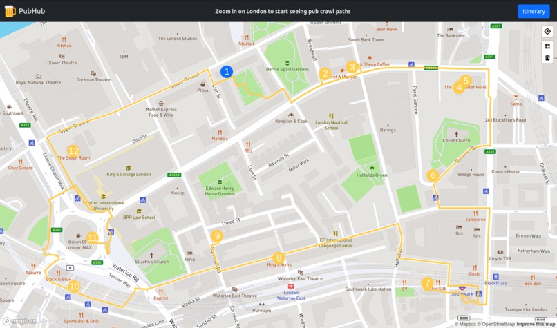
Showing the shortest route between a number of pubs near Waterloo Station
-

Shows an itinerary with statistics about the number of stops, the total distance, and the required time


Inspiration
We were inspired by the wealth of open data provided by OpenStreetMap, and decided we wanted to create a web application that utilized this tool.
What it does
The web app displays the shortest path between a series of pub and bars within a given area. This may be the currently viewed area or a polygon drawn out by the user.
How we built it
- Frontend built using React, Mapbox-GL and Bootstrap, hosted on Netlify, behind a domain.com domain name
- Overpass for querying OSM
- Self-hosted Valhalla instance for efficient OSM-based routing
- Django API for handling the complexities of parsing Valhalla query results
Challenges we ran into
- Team members had minimal previous use of React, so had to learn during the hackathon
- Overpass has a very *interesting* query language that took some time to adopt and understand
Accomplishments that we're proud of
- We were able to create a intuitive UI using React
- That we able to utilize a wide variety of tools & technologies to create a functioning application
What we learned
- Learnt how to create a component-based UI using React
- How to make use of Reacts Context API to manage global state
Built With
- bootstrap
- caddy
- django
- docker
- docker-compose
- domain.com
- google-cloud
- google-compute-engine
- mapbox
- netlify
- openstreetmap
- overpass-openstreetmap
- python
- react
- valhalla


Log in or sign up for Devpost to join the conversation.