-
-
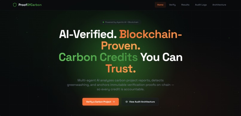
Landing Page
-
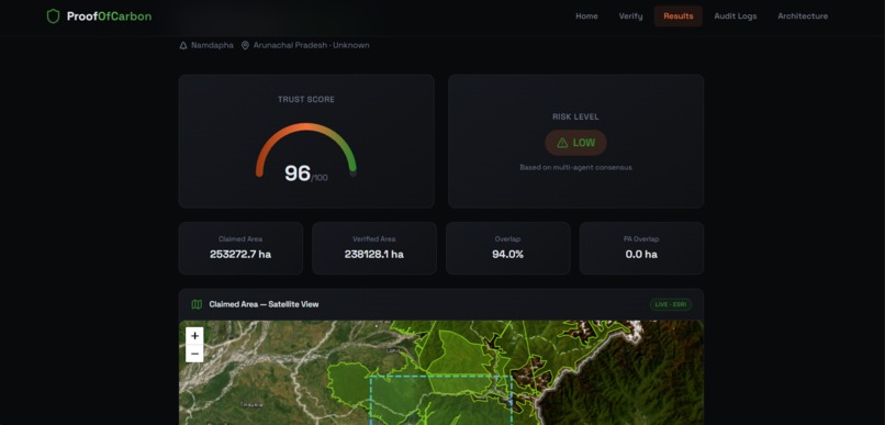
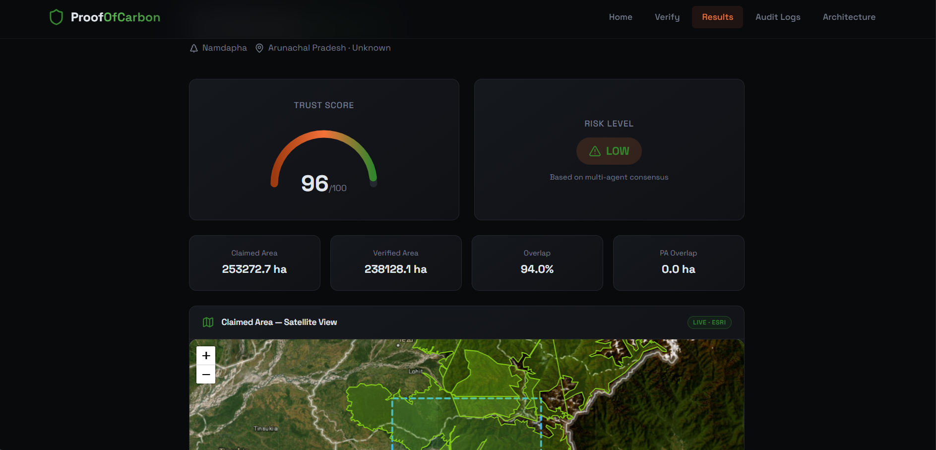
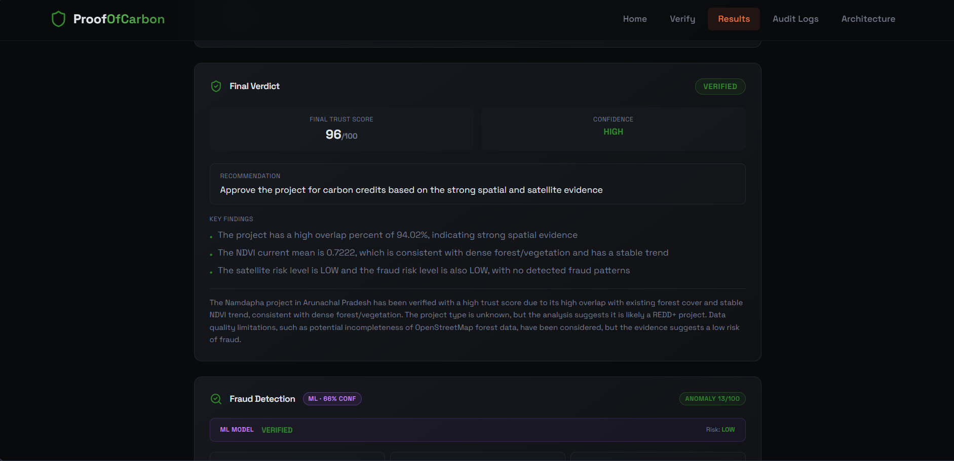
Results
-
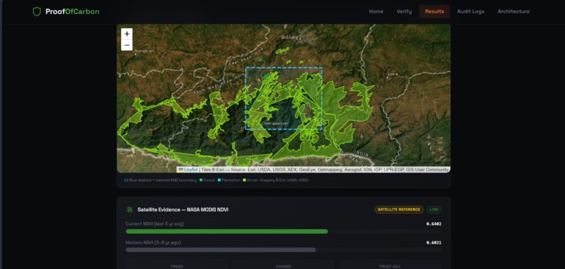
Results
-
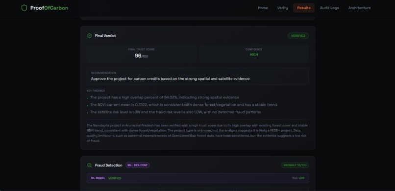
Results
-
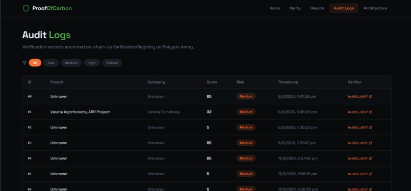
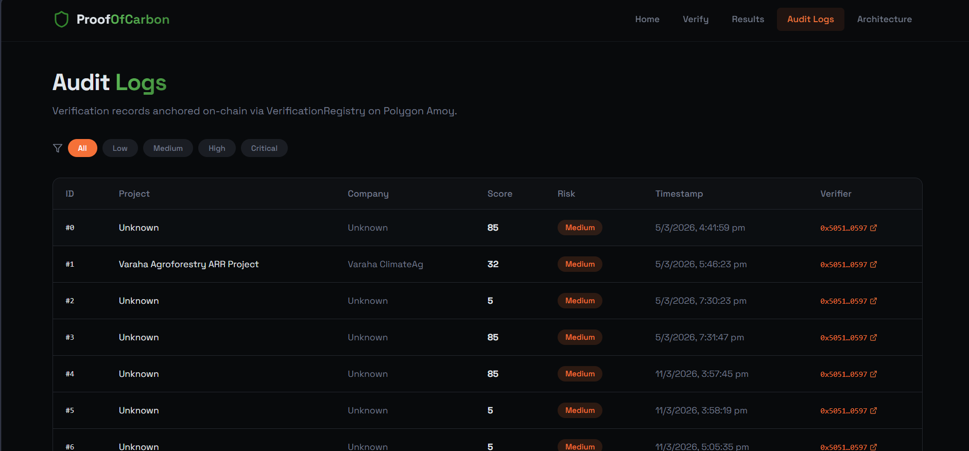
Audit logs
-
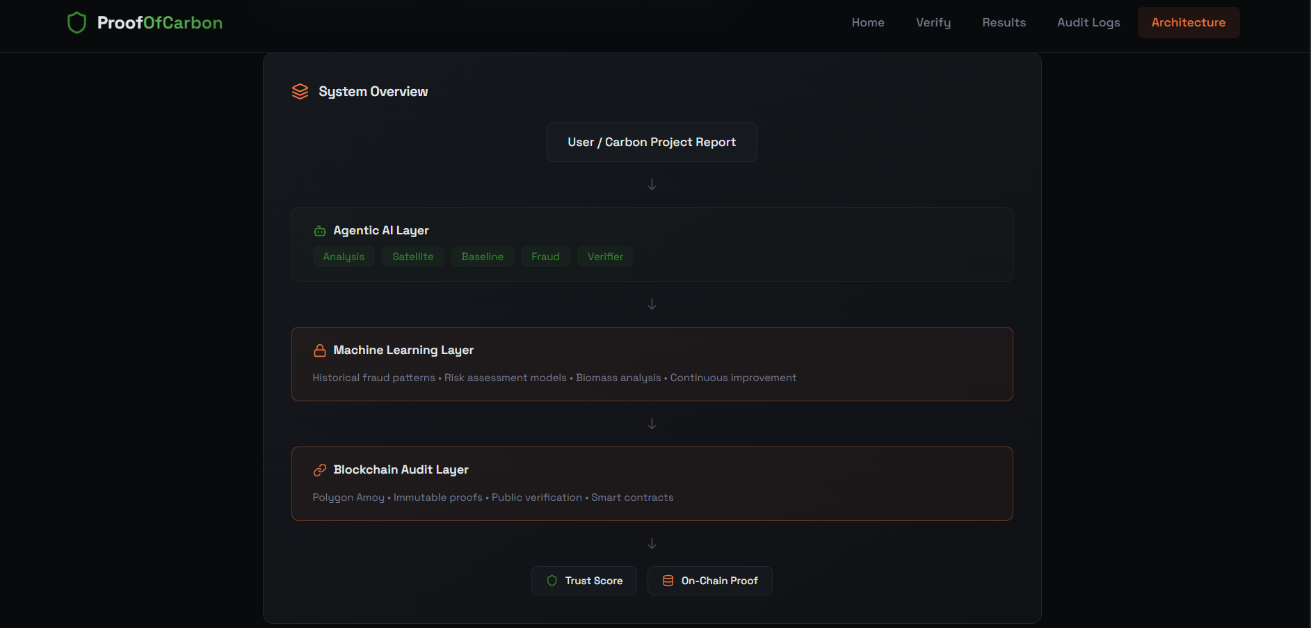
Architecture page


Proof of Carbon
AI-Powered Carbon Credit Verification · Geospatial Intelligence · Immutable Blockchain Audit Trails
The voluntary carbon market is broken. We built the infrastructure to fix it.
Problem Statement
UN SDG Addressed: SDG 13 — Climate Action (Supporting SDGs 15: Life on Land · 17: Partnerships for the Goals)
The voluntary carbon market surpassed $2 billion in 2023 and is projected to hit $50 billion by 2030 — yet it operates largely on trust, paperwork, and optimism.
The cracks are severe:
- Studies suggest up to 90% of certain rainforest carbon credits are ineffective or overstated
- Audit cycles run 12–18 months — far too slow for real-time markets
- Verification relies on human auditors with inconsistent standards and siloed registries (Verra, Gold Standard) that cannot cross-check fraud
- Raw satellite data exists, but requires expensive expert interpretation
- There is no single system connecting geospatial evidence, fraud intelligence, and an immutable audit record
The result: rampant greenwashing, double-counting, and a market that climate finance cannot trust. Without better verification infrastructure, the majority of that $50 billion will flow into credits that deliver no real climate benefit.
No standardised, automated, end-to-end verification mechanism exists at scale. That is the gap Proof of Carbon fills.
Our Solution
Proof of Carbon is a full-stack AI verification pipeline that takes a carbon credit project's geospatial file and produces a cryptographically anchored trust verdict — in minutes, not months.
Upload a .KMZ file. Get back a Trust Score, a Risk Classification, a detailed Verification Report, and an on-chain audit hash that can never be altered.
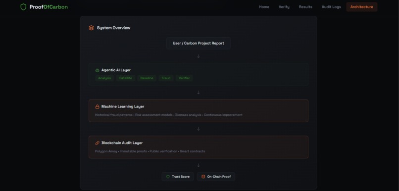
How AI Powers It
The system runs a five-agent AI pipeline, where each agent has a bounded, well-defined role — and all work together to produce a cross-validated verdict:
KMZ Upload → Project Analysis → Satellite Evidence → Baseline & Additionality
           → Fraud Detection → LLM Verifier → Trust Score + Blockchain Anchor
| Agent | Role | Data Sources |
|---|---|---|
| Project Analysis | Extracts polygon, computes UTM area, checks protected-area conflicts | GeoPandas, GeoJSON forest layers |
| Satellite Evidence | Retrieves NDVI vegetation index, validates canopy trends | Google Earth Engine |
| Baseline & Additionality | Computes REDD+ / ARR additionality against historical deforestation rates | FSI ISFR 2023 state-level CSVs |
| Fraud Detection | XGBoost model (99.75% accuracy) scores 13 cross-signal features; flags anomalies | XGBoost, 2,000 synthetic samples |
| LLM Verifier | Reasons over all evidence; produces structured, explainable verdict | Claude (Anthropic) with deterministic overrides |
Critically, LLM numeric outputs are overridden by deterministic tools — the AI reasons and explains, but cannot hallucinate a score.
Technical Architecture
Stack
- Frontend: React + Vite — clean upload interface, live score display, downloadable report
- Backend: FastAPI —
/analyzeendpoint orchestrating the full pipeline - Geospatial: GeoPandas, KMZ parser, Google Earth Engine (NDVI retrieval with multi-temporal trend analysis)
- ML: XGBoost fraud classifier
- Blockchain: Solidity
VerificationRegistry.solon Hardhat / Polygon Amoy testnet - Storage: IPFS for full reports; only hash + metadata anchored on-chain
ML Fraud Detection
The XGBoost model was trained on ~2,000 synthetic project samples (1,600 train / 400 test), mirroring real-world distributions of legitimate and fraudulent carbon projects across REDD+ and ARR typologies.
Test accuracy: 99.75%
Top feature importances:
| Feature | Importance | What It Catches |
|---|---|---|
flag_count |
26.4% | Cumulative red flags across all agents |
additionality_score |
20.0% | Projects with near-zero deforestation pressure |
protected_area_overlap_ha |
12.1% | Illegal boundary conflicts |
overlap_percent |
11.3% | Projects claiming forest with zero measured coverage |
ndvi_change |
7.9% | Vegetation degradation or fabricated improvement |
The strongest fraud signal isn't any single anomaly — it's the cumulative weight of cross-agent flags combined with near-zero climate additionality. A project can survive one weak signal; it cannot survive all five agents flagging problems simultaneously.
Blockchain Layer
Full reports stay off-chain (IPFS); only the content hash + metadata are anchored on-chain via Polygon Amoy, keeping gas costs minimal while preserving tamper-proof auditability.
Impact
Live Demo: Two Projects, Two Verdicts
✅ Khasi Hills Community REDD+ Project, Meghalaya India's first community REDD+ project (Plan Vivo certified, 23,507 ha). Dense subtropical cloud forest. NDVI baseline 0.72 → current 0.81. High deforestation pressure confirms additionality. Result: High trust score. Low risk.
🚨 GreenEarth ARR Initiative, Barmer, Rajasthan (Fabricated fraud case) Claims 48,500 ha of reforestation in the Thar Desert. Self-reported NDVI of 0.81 against real satellite NDVI of 0.08–0.15. Monitoring plots placed 47km outside the project boundary — one in Pakistan. Sub-zone overlaps Desert National Park. Claimed 2.4M tCO2e, which is 3× the mathematical maximum for the site. Result: Critical fraud flags across all five agents. Rejected.
The system correctly distinguished a genuine project from a fabricated fraud case using only geospatial and ML signals — no human input.
Why It Matters by 2030
The voluntary carbon market is projected to reach $50 billion by 2030. Proof of Carbon is designed to be the trust layer the carbon market is missing — automated enough to scale globally, rigorous enough to catch fraud, transparent enough that buyers, sellers, and regulators can all verify the same evidence.
AI + satellite intelligence + blockchain, working together, can make climate finance actually work.
What Makes It Different
| Capability | Human Auditors | Satellite Tools | Registry Systems | Proof of Carbon |
|---|---|---|---|---|
| Geospatial fraud detection | ✗ | Partial | ✗ | ✅ |
| NDVI / satellite evidence | ✗ | ✅ | ✗ | ✅ |
| Additionality computation | Slow | ✗ | ✗ | ✅ |
| Cross-signal ML fraud scoring | ✗ | ✗ | ✗ | ✅ |
| Explainable AI verdict | ✗ | ✗ | ✗ | ✅ |
| Immutable audit trail | ✗ | ✗ | Partial | ✅ |
| Real-time turnaround | ✗ | Partial | ✗ | ✅ |
Challenges We Overcame
Geospatial–ML integration — connecting polygon-level spatial outputs (forest overlap %, area in ha) as clean numeric features into an XGBoost pipeline required careful feature engineering and consistent coordinate projection (WGS84 → UTM).
Preventing LLM hallucination in verification — the LLM agent produces reasoning, but all numeric scores are hard-overridden by deterministic module outputs. If a module returns None (missing data), the score falls back gracefully rather than letting the LLM guess.
Coverage gaps in reference data — our initial india_forest_cover.geojson had zero polygons for Northeast India, causing valid projects in Meghalaya to score as barren land. We rebuilt the reference dataset to 45 features covering all major Indian forest zones, including 10 dedicated Meghalaya polygons.
Scalable blockchain storage — storing full reports on-chain is prohibitively expensive. Our architecture keeps reports on IPFS and anchors only a content hash + metadata on-chain, keeping gas costs minimal while preserving tamper-proof auditability.
What We Learned
- Geospatial data processing with GeoPandas and KMZ parsing at scale
- The practical complexity of REDD+ and ARR additionality rules and why they're so easy to game
- How to design multi-agent AI pipelines where each agent has a bounded, well-defined role
- NDVI as a fraud signal — the gap between self-reported and satellite-measured vegetation is one of the strongest fraud indicators in carbon markets
- How to design blockchain-backed audit infrastructure that balances transparency with cost
What's Next
Near-term
- Real Google Earth Engine integration with live NDVI pulls replacing mock fallback
- Retrain XGBoost on real project data sourced from Verra and Gold Standard public registries
- Fine-tuned LLM on Verra VCS and Gold Standard methodology documents
- Active learning loop — auditor corrections on edge cases fed back into the training pipeline
Medium-term
- Multi-modal inputs — drone imagery, field photographs, LiDAR canopy height data
- ERC-1155 tokenised carbon credits with embedded verification score
- DAO governance layer for dispute resolution
Long-term
- Expand reference datasets beyond India to global biomes
- UNFCCC national reporting portal integration
- ISO 14064-compliant report generation
- White-label SaaS for auditing firms and carbon registries
References
- Forest Survey of India (FSI), India State of Forest Report 2023 (ISFR 2023)
- Verra Verified Carbon Standard (VCS) Registry — public project database
- Gold Standard Foundation — project certification database
- West et al. (2023), Overstated carbon emission reductions from voluntary REDD+ projects, Science
- IPCC AR6 Working Group III — Chapter 7: Agriculture, Forestry and Other Land Use
- Google Earth Engine — NDVI / Landsat / Sentinel data APIs
- Plan Vivo Foundation — Khasi Hills REDD+ Project documentation
- GeoPandas, XGBoost, FastAPI, Hardhat, Polygon Amoy documentation
Built With
- agents
- ai
- amoy
- blockchain
- css
- fastapi
- geopandas
- google-earth
- groq
- kmz
- llm
- ml
- ndvi
- openstreetmap
- python
- react
- tailwind
- typescript


Log in or sign up for Devpost to join the conversation.