-
-
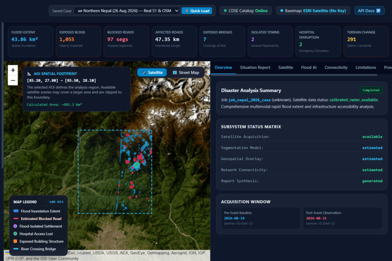
dashboard
-
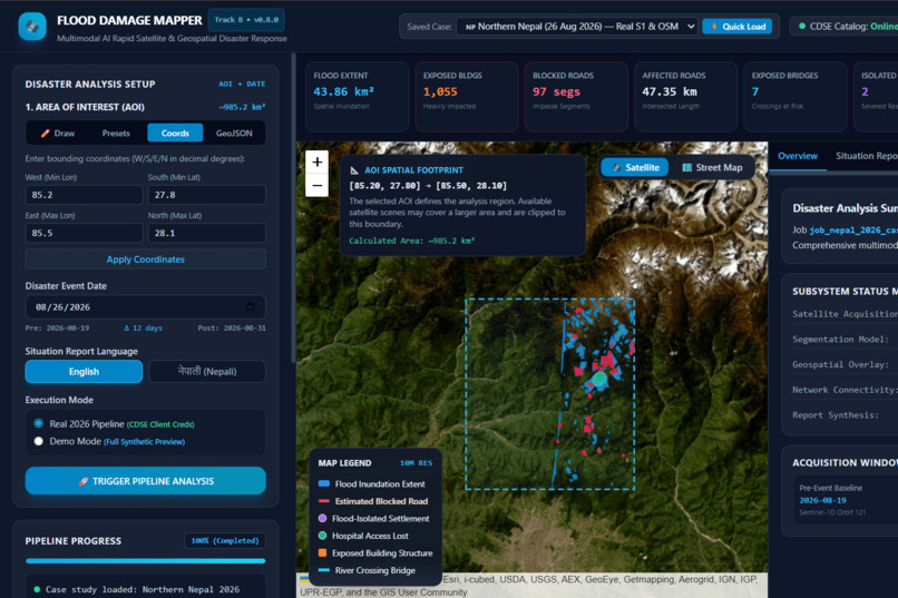
multiple ways to give input
-
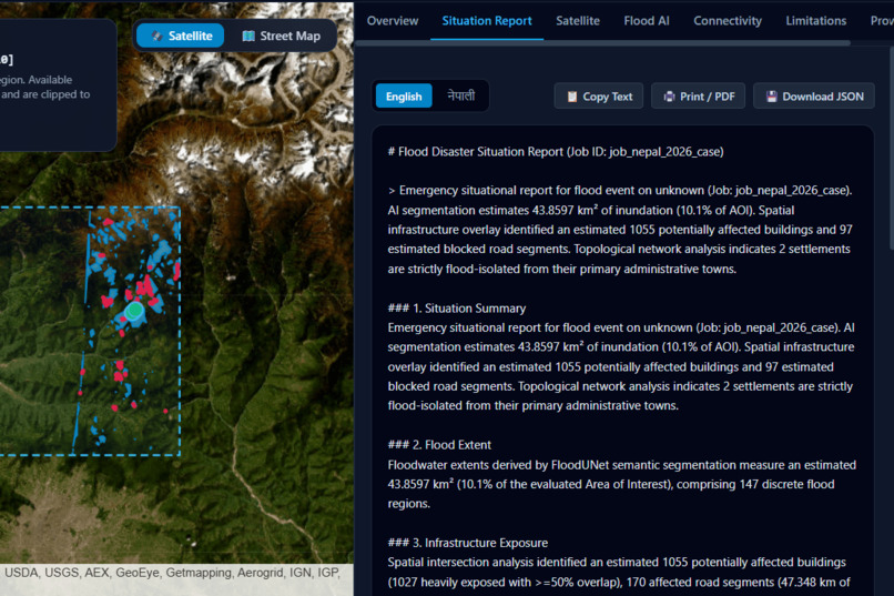
situation report
-
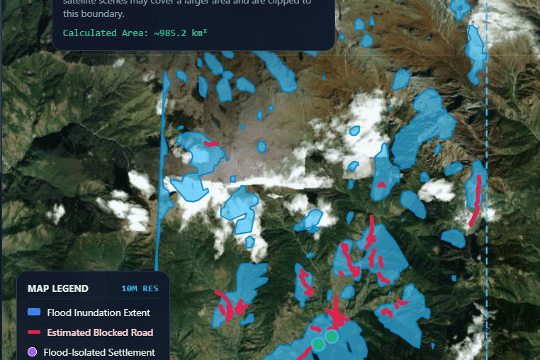
Live map
Inspiration
Floods occur all of a sudden and cause a huge damage to homes,roads,bridges,and essential infrastructre within hours. Understanding the extend of the damage quickly is very crucial for effective disaster response.we wanted to exploree how satellite imagery and AI could help us turn this large amounts of observable data into some meaningful insights and information for the responders.
What it does
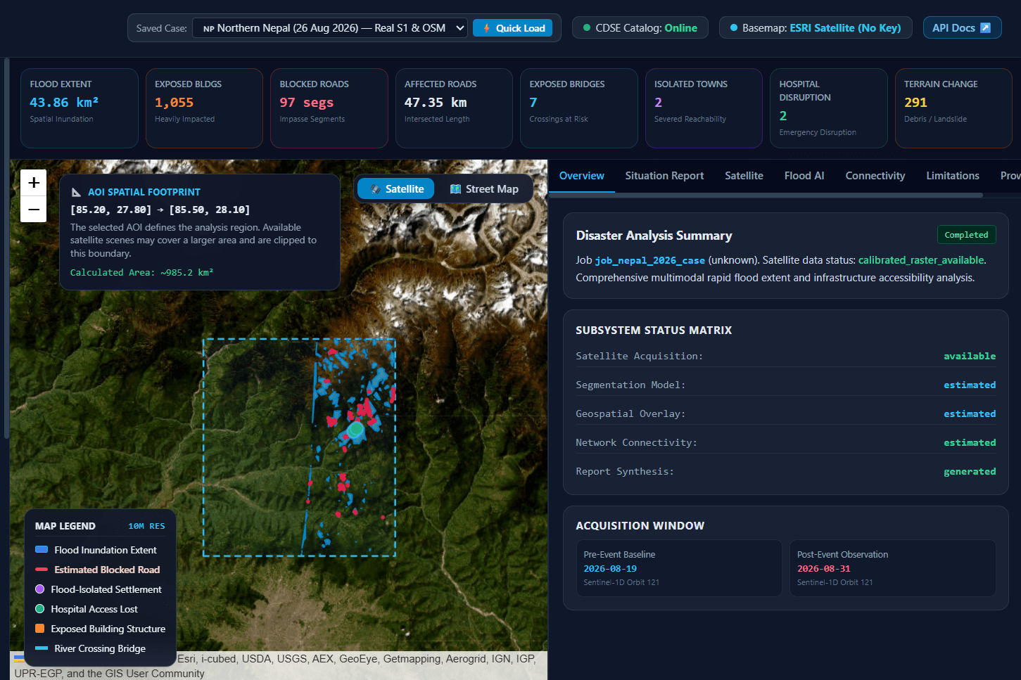
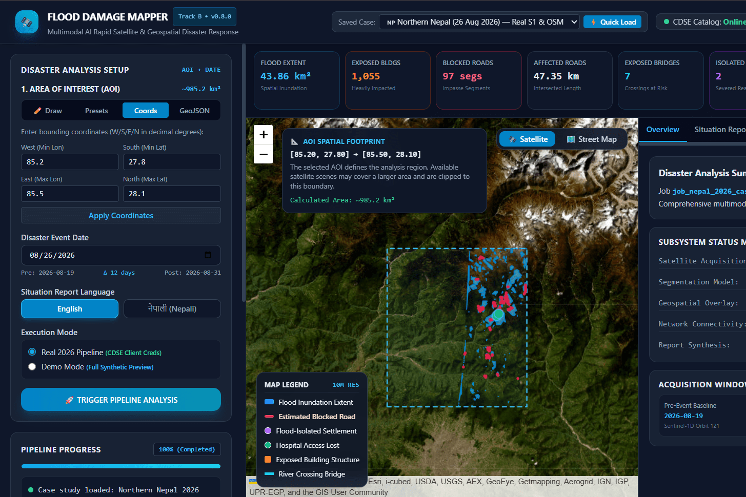
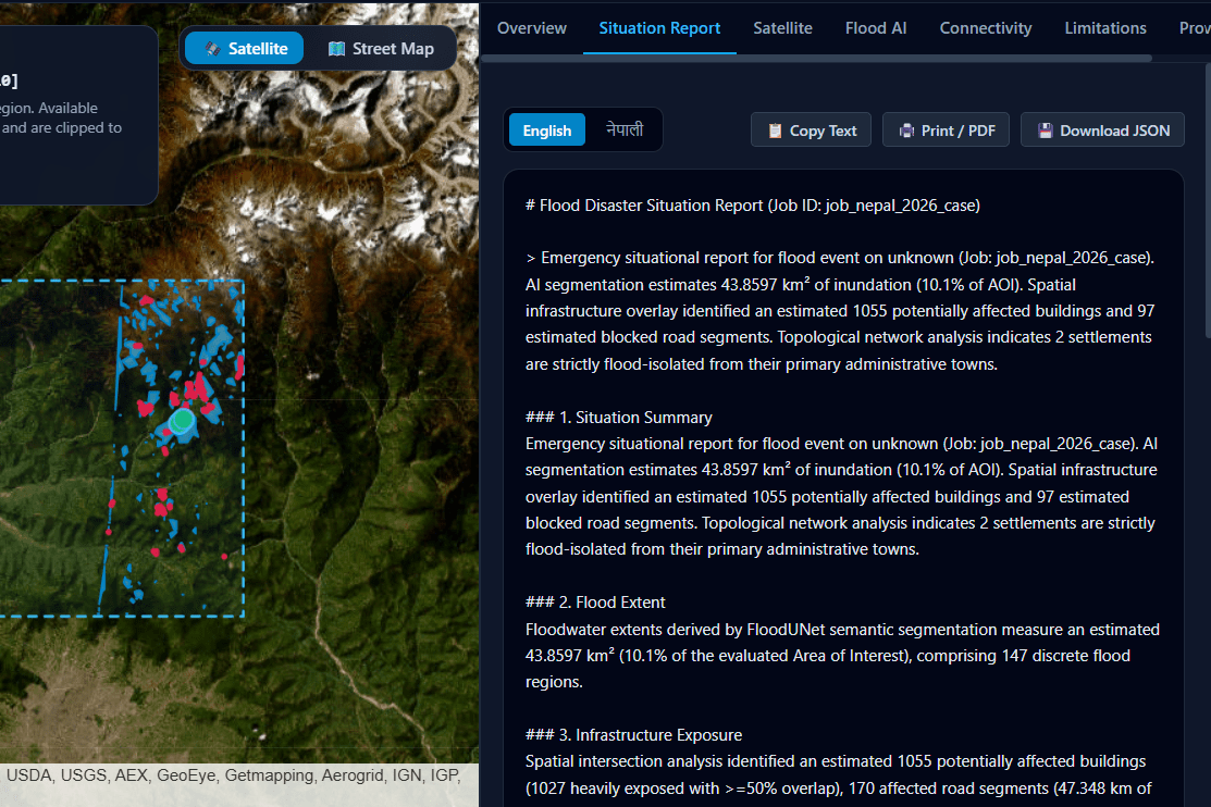
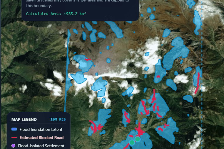
FloodScope is our AI-powered flood mapping and infrastructure assessment project. We use satellite imagery, deep learning, and geospatial analysis to understand how floods affect different areas. Users can select an area on the map or enter geographic coordinates and choose a flood event date. Our system discovers Sentinel-1 SAR and Sentinel-2 satellite imagery from before and after the event and prepares the data for analysis. We integrate the FloodUNet deep learning model for flood segmentation to identify potential inundated regions. Using GIS-based processing and OpenStreetMap (OSM) data, we map the flood extent and assess potentially exposed buildings, roads, and bridges. We also explore road connectivity to help identify areas that may become difficult to access during floods. All these capabilities come together in an interactive map with analysis results and multilingual situation reports in English and Nepali. Through FloodScope, our goal is to turn complex satellite and geographic data into useful insights that can help people understand flood impacts and support disaster response planning.
How we built it
We built FloodScope using a React and Vite frontend and a Python FastAPI backend. The frontend provides an interactive interface where users can select an area of interest, specify a flood event date, and visualize analysis results on a map. On the backend, we developed a satellite data pipeline to discover Sentinel-1 SAR and Sentinel-2 optical imagery through the Copernicus Data Space Ecosystem. The pipeline is designed to select pre-event and post-event scenes and prepare the imagery for AI-based analysis. For flood segmentation, we integrated the FloodUNet deep learning model. We use geospatial processing tools to convert predicted flood regions into geographic layers and calculate flood extent. We also integrated OpenStreetMap data to map buildings, roads, and bridges within the selected area and assess their potential exposure to flooding. We organized these components into backend services and API endpoints for satellite discovery, image preprocessing, flood analysis, infrastructure assessment, and report generation. The results are presented through an interactive map and structured summaries, with multilingual situation reports in English and Nepali. Throughout development, we focused on supporting different locations and event dates, keeping results tied to the selected area, and handling missing or invalid satellite data without presenting it as a confirmed absence of flooding.
Challenges we ran into
One of our biggest challenges was building a complete pipeline from satellite data discovery to meaningful flood analysis. Finding suitable Sentinel-1 SAR and Sentinel-2 scenes was only the first step; downloading the imagery, preprocessing it into usable raster data, and ensuring it was ready for AI inference introduced additional complexity. Another challenge was integrating satellite imagery with the FloodUNet model and geospatial processing tools. We needed to ensure that the predicted flood regions aligned correctly with geographic coordinates so that infrastructure exposure estimates would be meaningful. We also worked on making the platform adaptable to different locations and flood dates rather than relying on fixed example regions or results. Keeping each analysis tied to its own area of interest, handling missing satellite data, and distinguishing unavailable results from a genuine prediction of no flooding required careful backend logic. Finally, combining flood maps with OpenStreetMap data to assess buildings, roads, bridges, and road connectivity presented its own challenges. We learned that building a reliable disaster assessment tool requires more than AI alone it also depends on data quality, geospatial accuracy, and transparent reporting of uncertainty.
Accomplishments that we're proud of
We’re proud of bringing together satellite remote sensing, AI-based flood segmentation, and geospatial analysis into a single platform. FloodScope combines Sentinel-1 SAR and Sentinel-2 imagery discovery with the FloodUNet model and OpenStreetMap infrastructure data to support flood impact assessment. We built an interactive web interface that allows users to define their own areas of interest and select flood event dates, with the goal of making the analysis adaptable to different regions rather than limited to predefined examples. We’re also proud of integrating multiple geospatial capabilities, including flood-region mapping, infrastructure exposure assessment for buildings, roads, and bridges, road connectivity analysis, and multilingual situation report generation in English and Nepali. Most importantly, this project helped us tackle the complexity of connecting satellite data, AI models, and real-world geographic information in one workflow. We’re proud of the system we’ve developed and the foundation it provides for more accessible, data-driven disaster assessment.
What we learned
Through building FloodScope, we learned how challenging it is to turn raw satellite imagery into meaningful, real-world insights. We explored how Sentinel-1 SAR and Sentinel-2 optical imagery can support flood analysis, and how satellite data must be carefully selected, downloaded, and preprocessed before it can be used by a deep learning model. We gained practical experience integrating the FloodUNet model with geospatial processing and combining flood predictions with OpenStreetMap data to assess potentially exposed infrastructure. We also learned the importance of geographic accuracy, data quality, and ensuring that results correspond to the user's selected location and flood event date. Another key lesson was that an AI model alone is not enough to build a reliable disaster assessment system. The complete workflow—from data acquisition and preprocessing to analysis, visualization, and reporting—must work together. Overall, FloodScope helped us strengthen our understanding of AI engineering, satellite remote sensing, GIS, backend development, and the importance of communicating uncertainty when building technology for real-world disaster response.
What's next for FloodScope
Next, we aim to improve FloodScope's end-to-end satellite data pipeline, making it faster and more reliable for analyzing different locations and flood events. We plan to strengthen FloodUNet predictions through validation against independent flood maps and ground-truth data, while improving the accuracy of flood extent estimation and infrastructure exposure assessment.
We also want to expand road connectivity analysis to identify potentially isolated communities, integrate more reliable and up-to-date infrastructure data, and enhance multilingual reports to support disaster response teams across different regions. Further improvements will focus on processing efficiency, cloud deployment, and making the platform accessible to emergency responders and disaster management organizations.
Our long-term vision is to evolve FloodScope into a scalable geospatial intelligence platform that helps communities and response teams understand flood impacts earlier and make better-informed decisions during disasters.
Built With
- computer-vision
- corpenicus
- deep-leaning
- earth-observing-system
- fastapi
- floodunet
- geojson
- gis
- image-segmentation
- machine-learning
- mngeo-geospatial-image
- multilingual-ai
- natural-language-processing
- openstreetmap
- postgresql
- python
- raster
- react
- remote-sensing
- satellite-imagery
- sentinel-monitoring
- vite


Log in or sign up for Devpost to join the conversation.