-
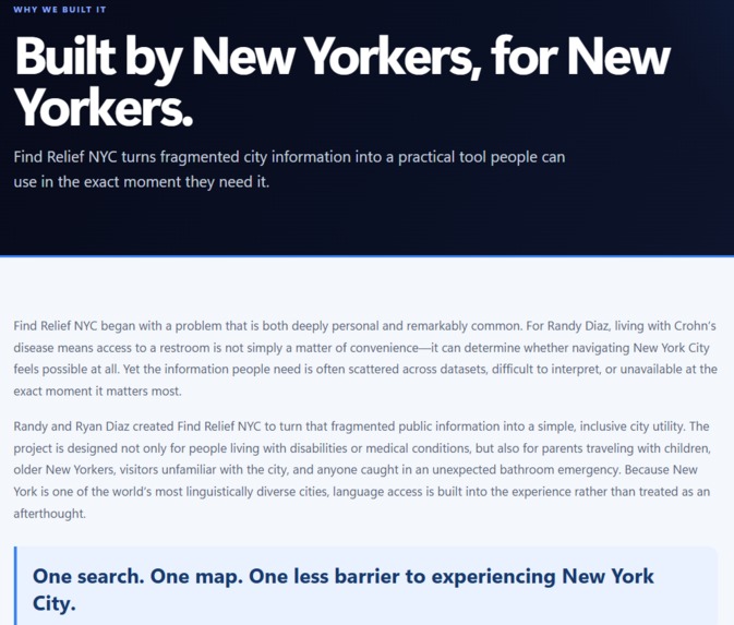
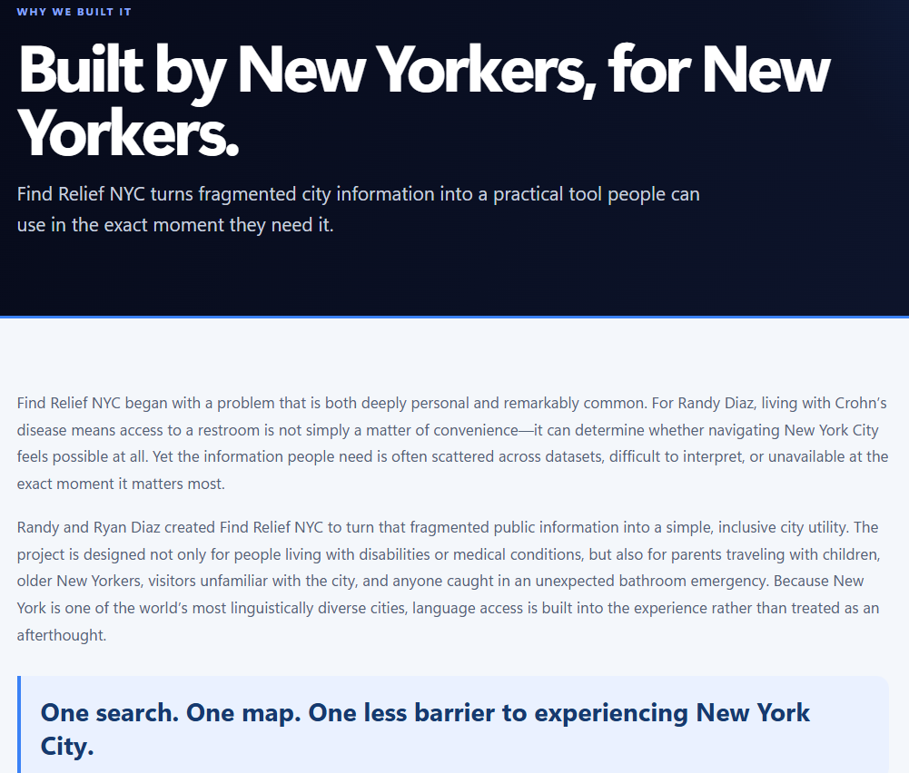
Built from lived experience, then expanded into an inclusive tool designed to help all New Yorkers navigate with confidence.
-
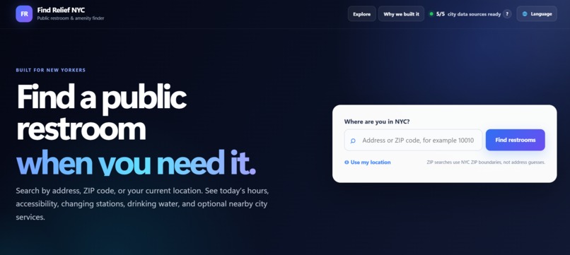
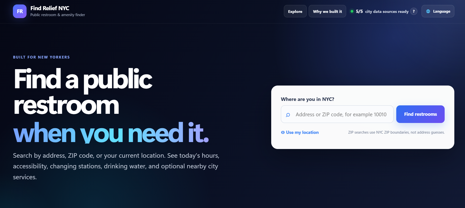
Search by address, ZIP, or current location to quickly find nearby public restrooms and essential NYC amenities.
-
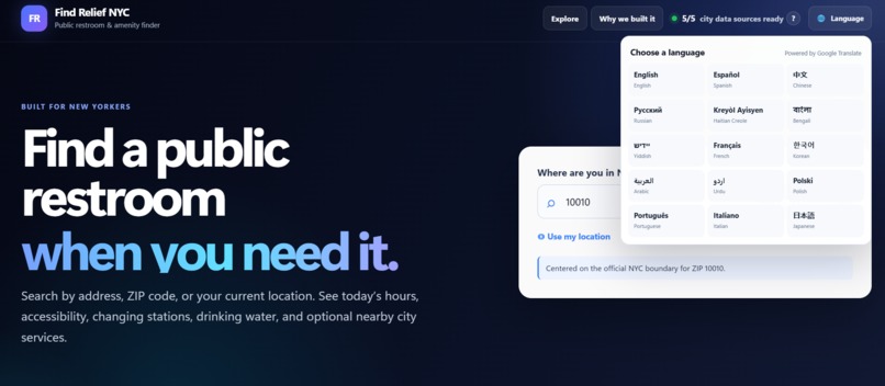
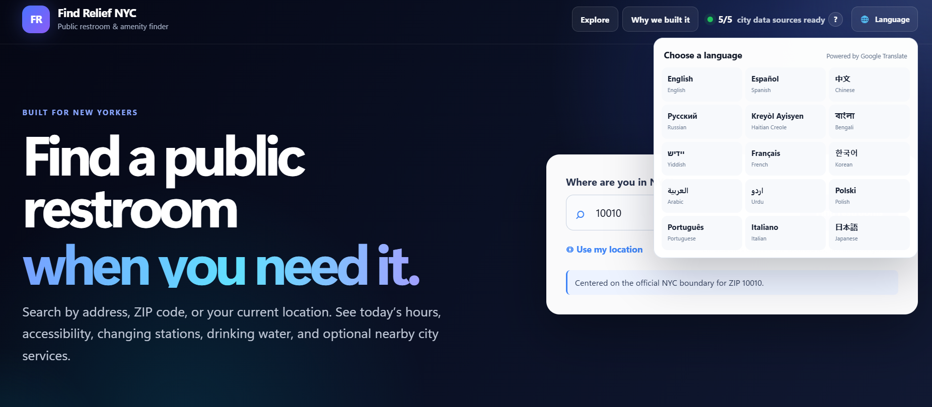
Built for a multilingual city, with language access designed to make public information easier to use.
-
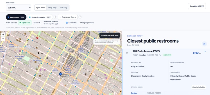
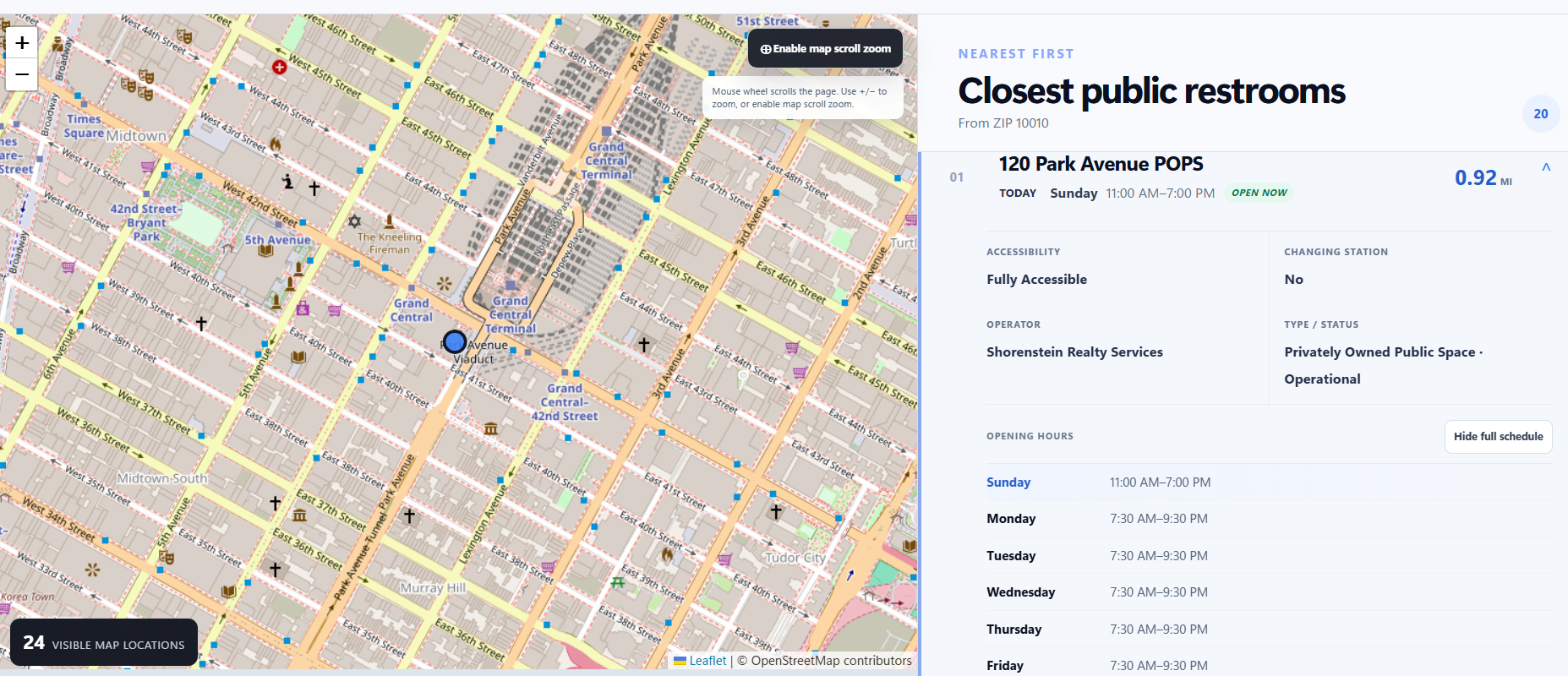
See nearest restrooms with today’s hours, open-now status, accessibility, changing stations, and directions.
-
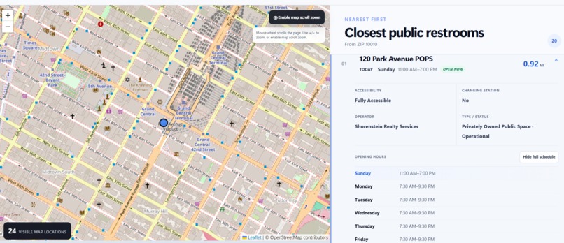
NYC restroom data is reorganized into clear schedules and practical details people can use immediately.

🚻 Find Relief NYC
Public restrooms and essential city amenities — when minutes matter.
Find Relief NYC transforms fragmented New York City public data into a fast, accessible, multilingual tool for finding nearby public restrooms and essential amenities.
The idea started with a deeply personal problem — but quickly became a solution we realized could help millions of New Yorkers.
💡 Inspiration
For most people, finding a restroom is an inconvenience.
For Randy Diaz, who lives with Crohn's disease, access to a restroom can determine whether going out in New York City feels manageable at all.
When restroom access is uncertain, even a normal day can require planning around questions like:
- Where is the nearest bathroom?
- Will it actually be open?
- Is it accessible?
- Does it have a changing station?
- If I suddenly need one, how quickly can I get there?
For people with urgent gastrointestinal conditions, disabilities, pregnancy-related needs, older adults, or parents with young children, the time between realizing you need a restroom and actually finding one can be extremely short.
Most people do not plan their day around bathrooms. They start searching only after the need has already arrived.
That led us to one of the core ideas behind Find Relief NYC:
When the need happens, searching cannot become another problem.
For Randy, having this information available ahead of time provides something equally important: peace of mind.
It can be the difference between confidently planning a day outside and staying home because of the anxiety of not knowing where a usable restroom will be.
🗽 What it does
Find Relief NYC gives users one place to quickly search for public restrooms and related city amenities.
Users can search using:
- 📍 Their current location
- 🏙️ A New York City address
- 📮 A ZIP code
The app then helps them identify nearby public restrooms using practical information such as:
- 🟢 Whether the restroom appears to be open now
- 🕐 Today's operating hours
- ♿ Accessibility information
- 👶 Changing-station availability
- 🚹 Men's changing-table information
- 🚺 Women's changing-table information
- 🧭 Distance from the user's location
- 🗺️ Directions
Rather than presenting users with raw government records, we reorganize the information around a much simpler question:
What do I need to know if I need a restroom right now?
👨👩👧 Designed for more than one use case
Although Find Relief NYC began with Randy's experience living with Crohn's disease, the same problem affects many different people.
A parent planning a day at a museum, park, parade, or neighborhood event can check where restrooms and changing stations are available before leaving home.
If a child suddenly says they need to go immediately, that same parent can use Find Relief NYC as a fast emergency resource instead of searching through multiple websites.
The tool can also support:
- People with Crohn's disease or IBS
- People with disabilities or mobility limitations
- Older New Yorkers
- Pregnant people
- Parents and caregivers
- Delivery workers
- Commuters
- Tourists unfamiliar with the city
- Anyone unexpectedly caught in a bathroom emergency
Our goal was to build something useful for people with specialized needs without making it feel like a specialized tool.
It should be useful to any New Yorker.
🚰 Beyond bathrooms
We realized the same public-data problem exists with other useful city resources.
Find Relief NYC therefore includes optional map layers for:
- 🚰 Public drinking-water fountains
- 📶 Free public Wi-Fi
- 🚲 Bike shelters
- 🏠 NYC drop-in centers
We deliberately kept these services optional so the primary restroom experience remains fast and uncluttered.
A simple example is hydration.
During a hot New York summer day or a heat wave, the useful question is not:
"Does New York City have drinking fountains?"
It is:
"Where is the closest public drinking fountain to me right now?"
Find Relief NYC helps turn city data into an answer someone can immediately act on.
♿ Accessibility by design
Accessibility was not treated as an extra feature.
Users can filter restroom results based on accessibility information and changing-station availability.
We also took a conservative approach to incomplete government records.
If NYC confirms a changing station exists but does not specify whether it is located in a men's or women's restroom, Find Relief NYC keeps the location available under Any instead of making an unsupported assumption.
If information is missing entirely, we clearly tell the user that NYC has not specified it.
We would rather show uncertainty than invent certainty.
🌐 Built for a multilingual city
New York is one of the most linguistically diverse cities in the world.
Public information is only useful if people can understand it.
Find Relief NYC includes language support so people from different linguistic backgrounds can more easily use the same city resources.
For us, accessibility means more than physical accessibility.
It also means making information understandable to the communities it is intended to serve.
🛠️ How we built it
Find Relief NYC is a responsive React application built with Vite, JavaScript, Leaflet, React Leaflet, NYC Open Data, NYC Planning GeoSearch, OpenStreetMap, browser geolocation, and translation tools.
We combined several different NYC datasets into one interface, including information for:
- Public restrooms
- Drinking fountains
- Public Wi-Fi
- Bicycle parking shelters
- Homeless drop-in centers
- ZIP-code geography
- Borough boundaries
NYC Planning GeoSearch powers address lookup, while ZIP searches use actual NYC ZIP geography rather than treating a ZIP code like a guessed street address.
Leaflet and OpenStreetMap power the interactive city map.
We also built custom logic to interpret operating-hour strings so users can see today's hours and whether a restroom appears to be open now based on current New York City time.
📡 Building for imperfect real-world data
One of the biggest lessons from this project was that public data is extremely valuable — but it is not always clean.
Different datasets use different structures. Some fields are incomplete. Hours may be written in inconsistent formats. Some city services provide coordinates while others provide only addresses.
Instead of hiding these problems, we designed around them.
Find Relief NYC:
- Normalizes multiple dataset formats
- Geocodes records when coordinates are unavailable
- Parses inconsistent restroom hours
- Clearly labels missing information
- Avoids claiming a restroom is open when the schedule cannot be confidently interpreted
- Caches successful city-data responses when possible
- Shows whether data sources are live, cached, loading, or unavailable
This became one of the most important engineering principles of the project:
Make the public data more useful without pretending it is more complete than it really is.
🧩 Challenges we faced
Inconsistent public datasets
Our biggest technical challenge was combining multiple NYC datasets that were never designed to operate as one product.
Field names, coordinates, addresses, hours, and availability information can vary significantly between sources.
We built normalization and fallback logic so those differences would not become the user's problem.
Operating hours
Restroom schedules can appear as inconsistent text strings rather than predictable structured data.
We created custom parsing logic to convert many of these records into readable daily schedules and determine when an Open now status could be shown confidently.
Missing information
Accessibility and changing-station fields are not always complete.
We made a deliberate product decision not to treat missing data as either "yes" or "no."
Instead, the interface tells the user when NYC has not specified the information.
Location access
Browser and operating-system privacy settings can prevent geolocation from working.
Rather than making GPS mandatory, Find Relief NYC supports address and ZIP searches as equally important alternatives.
Keeping the experience simple
It would have been easy to turn the project into a map filled with dozens of city datasets.
We instead focused on the emergency use case first and placed secondary amenities behind optional controls.
🧠 What we learned
The biggest lesson was that open data and usable information are not the same thing.
A city can publish thousands of records, but that does not automatically make those records useful to someone standing on a sidewalk who needs an answer immediately.
We learned to think less about:
"How much data can we display?"
and more about:
"What decision is the user trying to make?"
For Find Relief NYC, that decision might be:
- Can I leave home confidently?
- Where is the nearest restroom?
- Is it open?
- Is it accessible?
- Is there a changing station?
- Where can I get water nearby?
That shift shaped the entire product.
🏆 What we're proud of
We are proud that Find Relief NYC began with one person's lived experience and developed into something that can serve a much broader population.
The project combines:
personal experience + public data + accessibility + real-world urgency
into one civic utility.
For Randy, the value is especially simple:
Planning ahead gives me peace of mind. Finding a restroom quickly gives me a safety net when planning is not enough.
🚀 What's next
Find Relief NYC could grow beyond the hackathon by adding:
- More detailed accessibility information
- Verified restroom updates
- Additional family-friendly facilities
- Better real-time closure information
- Heat-emergency resources
- Cooling centers
- Public water refill stations
- Transit-aware routing
- Community feedback
- Additional languages
- More resilient offline functionality
The same architecture could also be adapted for other cities with strong open-data programs.
❤️ Our mission
We did not want to simply put government records on a map.
We wanted to turn information that already belongs to New Yorkers into something they can actually use at the moment they need it most.
One search. One map. One less barrier to experiencing New York City.
Built by The Diaz Brothers — Randy Diaz & Ryan Diaz — of RedTail Digital Group.
Built With
- api
- css3
- data
- geosearch
- github
- gps
- html5
- javascript
- leaflet.js
- localstorage
- maps
- nyc
- open
- openstreetmap
- planning
- react
- socrata
- translate
- vite


Log in or sign up for Devpost to join the conversation.