-
-
EPPE Banner
-
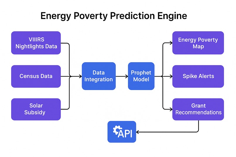
EPPE Architecture Diagram
-
Banner 2
-
Banner 1
-
Banner 3
-
Banner 5
-
Banner 4


📖 Inspiration
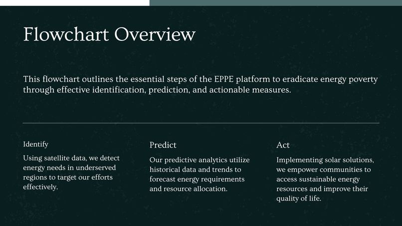
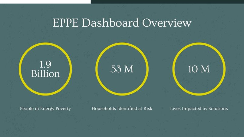
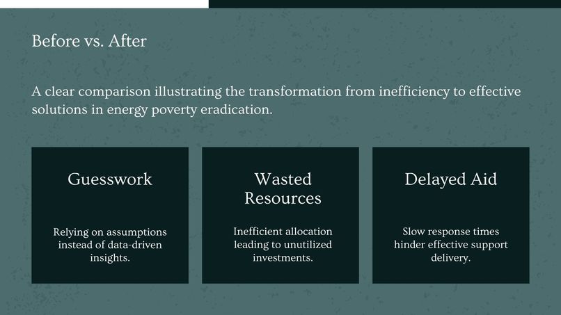
Globally, 800 million people live in energy poverty. Billions in aid are deployed annually, but these resources are often misdirected due to outdated data, making interventions reactive and inefficient. We were inspired to fix this targeting problem. So, we built EPPE: a predictive intelligence engine that empowers governments and NGOs to identify and act on energy poverty with unparalleled precision. Our mission: to make humanitarian aid predictive, proactive, and profoundly more impactful.
⚙️ What It Does
EPPE orchestrates the entire journey from raw global data to targeted, life-changing interventions.
✅ Real-time Identification: Integrates VIIRS satellite nightlight data with demographic census data to provide a current, granular view of electricity access, bypassing slow, expensive manual surveys.
✅ Predictive Forecasting: Leverages the Prophet time-series model to forecast future energy cost spikes, grid instability, or increasing poverty signals in specific regions weeks in advance.
✅ Actionable Intelligence: Matches predicted high-risk zones directly with a database of relevant, available local or regional subsidy programs (e.g., solar panel initiatives, microgrid funding).
✅ Dynamic Visualization: A live map-based dashboard built with Leaflet.js provides an intuitive, visual interface for users to easily identify high-risk zones and view predictive forecasts.
✅ Reproducible & Deployable: The entire stack is fully dockerized, allowing for easy setup, demonstration, and deployment by partner organizations in diverse operational environments.
🔍 How We Built It
- Frontend: Leaflet.js, HTML, CSS, & JavaScript, creating a lightweight, mobile-friendly interactive map dashboard that visualizes GeoJSON data and forecast overlays for non-technical users.
- AI & Prediction Engine: Facebook Prophet for its robustness in forecasting time-series data with strong seasonality, applied to VIIRS nightlight data to predict future energy poverty hotspots.
- Backend & API: A high-performance REST API built with FastAPI (Python), using Pandas and NumPy for large-scale data processing and analysis.
- Data Layer & Sources: PostgreSQL with the PostGIS extension stores and manages geospatial (GeoJSON) and census data. Data is ingested from VIIRS Satellite Nightlight & NASA FIRMS feeds.
- Deployment & DevOps: Docker ensures the entire complex stack can be easily deployed and run consistently by diverse organizations, crucial for operational feasibility.
- Architecture: Our architecture is designed to ingest, process, and align large, disparate datasets (satellite, census), apply advanced time-series forecasting, and deliver insights via a robust API and an interactive geospatial visualization tool.
⚡ Challenges We Ran Into
A key challenge was integrating and georeferencing disparate large-scale datasets, such as aligning temporal satellite imagery with varied and often outdated census data formats. Fine-tuning the Prophet model to generate accurate, actionable forecasts from noisy nightlight data required significant iteration. Finally, ensuring the entire processing pipeline was performant enough to provide near real-time insights on a user-friendly dashboard was a major engineering hurdle we successfully overcame.
🎉 Accomplishments That We're Proud Of
✅ End-to-End Functional MVP: Delivered a complete platform from data ingestion to predictive insight and actionable recommendation.
✅ Dynamic Forecasting Implemented: Successfully integrated the Prophet model to provide real, forward-looking vulnerability forecasts.
✅ Live Subsidy Matching: The platform connects identified risk zones with a lookup of real-world, applicable aid programs.
✅ Fully Dockerized Stack: Achieved one-click reproducibility, making the platform easy to demo and deploy for partners.
✅ Compelling & Clear UX: Designed an intuitive map-based dashboard that makes complex data accessible and actionable for aid workers.
📚 What We Learned
We learned how to effectively productionize a time-series forecasting model (Prophet) for a novel social good application. The project deepened our expertise in processing and aligning large, complex geospatial and tabular datasets from sources like NASA and census bureaus. We gained significant experience in building a full-stack application with a modern Python backend (FastAPI) and a lightweight, powerful mapping frontend (Leaflet.js). Most importantly, we confirmed that by combining publicly available data with AI, we can create powerful tools that drive more efficient and impactful humanitarian action.
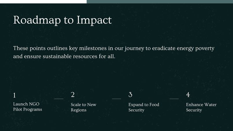
🚀 What’s Next for EPPE
"We aim to be the foundational engine for predictive humanitarian action."
- Secure Pilot Programs: Partner with key international NGOs or government agencies for pilot deployments to prove and refine EPPE's impact on aid effectiveness.
- Expand Predictive Capabilities: Broaden the platform's model to predict other crises like food insecurity (using crop/climate data) or water scarcity.
- Enhance the Platform: Develop a robust API for integration into existing GIS systems and build out advanced reporting tools compatible with standard aid agency frameworks.
- Scale Our Data Infrastructure: Seek funding to scale our data processing capabilities to cover more regions and ingest a wider variety of data sources.
- Build a Community of Practice: Foster a community of users and partners to share insights and improve the application of predictive analytics for social good.
Long-term, EPPE aims to become the essential platform for predictive social good, redefining the efficiency of humanitarian aid worldwide by replacing reaction with prediction.


Log in or sign up for Devpost to join the conversation.