-
-
1/2
-
2/2
Inspiration
The rising cases of crimes against women in India, particularly in Bengal, deeply moved me. Every day, news reports highlighted incidents that left women feeling unsafe in their own cities. I realized that fear was preventing women from exploring new places, traveling alone, and experiencing the world freely. I wanted to create something meaningful—a tool that could restore confidence and transform fear into freedom. That inspiration led to DEVINA: a safety companion that empowers women with real-time intelligence, so they can travel fearlessly and explore freely.
What it does
DEVINA is a comprehensive women's safety companion that goes beyond just providing a safety score. It delivers:
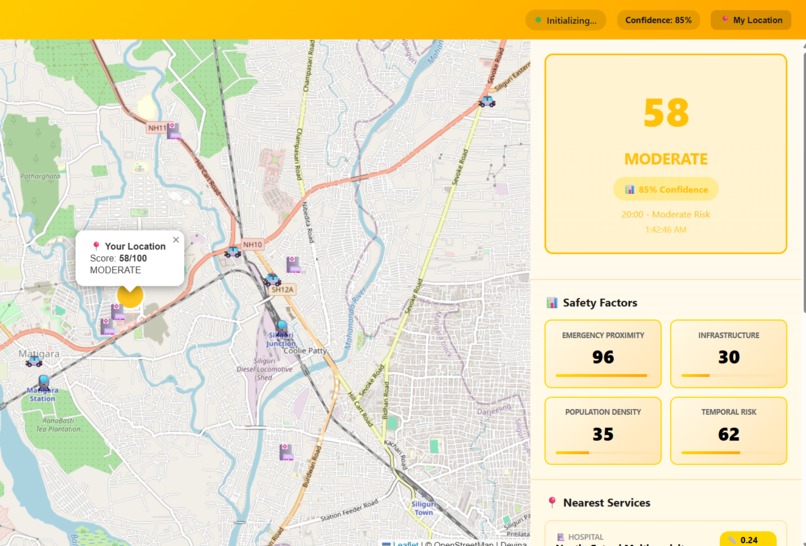
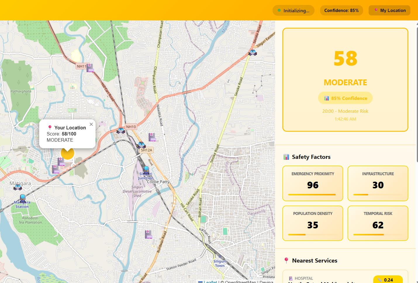
Real-time Safety Scoring (0-100): An instant assessment of your current location's safety based on four research-validated factors: temporal risk, emergency service proximity, population density, and infrastructure quality.
Interactive Live Map: Visual representation of your location with color-coded safety zones (green, yellow, orange, red) that update in real-time as you move.
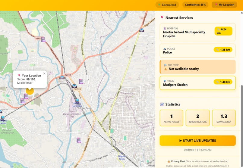
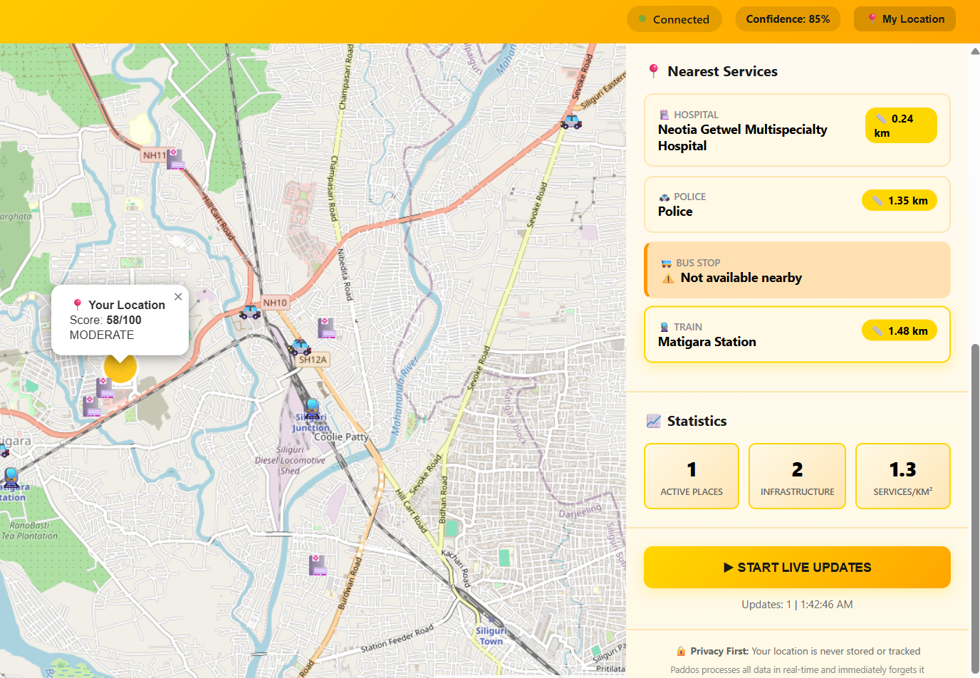
Emergency Services Detection: Automatically identifies and displays the nearest hospitals, police stations, bus stops, and train stations with exact distances, helping you know where to go if you need help.
Live Monitoring: continuous updates every 30 seconds, ensuring you always have the latest safety information.
Privacy-First Design: Your location is never stored—everything is processed in real-time and immediately deleted. No user accounts, no tracking, completely anonymous.
Mobile Responsive: Works seamlessly on any device, so you can access safety information anywhere, anytime.
DEVINA is designed to be more than a safety tool—it's a travel companion that combines safety intelligence with the promise of confident exploration, whether you're in familiar territory or discovering unknown places.
How we built it
Technology Stack:
- Backend: Python Flask framework with Flask-SocketIO for real-time WebSocket communication
- Frontend: HTML5, CSS3, and vanilla JavaScript with Leaflet.js for interactive mapping
- APIs: OpenStreetMap Overpass API for real-time geographic data, multiple IP geolocation services for location fallback
- Deployment: Render.com cloud platform with Gunicorn WSGI server and Eventlet for asynchronous networking
- Real-time: WebSocket protocol for instant bidirectional communication
Development Process:
- Algorithm Design: Researched and developed a multi-factor weighted algorithm based on the Women Peace & Security Index and urban safety studies
- Data Integration: Integrated OpenStreetMap API to fetch real-time data about emergency services, infrastructure, and population activity
- Real-time Architecture: Implemented WebSocket connections using Socket.IO for continuous location monitoring and instant updates
- Responsive Design: Built a mobile-first interface with yellow theming for warmth and approachability
- Privacy Implementation: Designed a stateless architecture with zero data persistence, ensuring complete user anonymity
- Cloud Deployment: Deployed on Render.com with automatic HTTPS, CI/CD from GitHub, and production-grade server configuration
Challenges we ran into
API Rate Limiting: OpenStreetMap's Overpass API has rate limits, requiring careful optimization of query frequency and implementing intelligent caching strategies without compromising real-time accuracy.
Location Accuracy: Balancing between GPS precision (battery-intensive) and IP-based location (less accurate). Implemented a fallback system that tries GPS first, then gracefully degrades to IP location while warning users.
Real-time Performance: Maintaining smooth WebSocket connections while processing heavy geographic queries. Solved by implementing asynchronous processing with Eventlet and optimizing data structures.
Deployment Challenges: Free tier cold starts on Render meant initial loads took 30-60 seconds. Addressed by adding clear loading messages and explaining the real-time data fetching process to users.
Cross-platform Consistency: Ensuring the map and real-time features worked identically on desktop and mobile browsers, particularly with location permissions and WebSocket stability.
Data Availability: Not all locations have complete OpenStreetMap data. Implemented a "service unavailable" detection system that gracefully informs users when sufficient data isn't available for accurate scoring.
Accomplishments that we're proud of
Production-Ready MVP: Built and deployed a fully functional application from scratch that's live and accessible at devina.onrender.com
Real-time Intelligence: Successfully implemented true real-time safety monitoring with WebSocket communication, updating every 30 seconds without page refreshes
Complex Algorithm: Developed a sophisticated safety scoring system with research-validated weights that adjusts for country-specific baselines and multiple safety factors
Privacy-First Architecture: Created a system that's genuinely anonymous—no databases, no tracking, no data retention—while still providing personalized, location-specific safety information
Global Coverage: DEVINA works in 195 countries with intelligent fallbacks and service availability detection
User Experience: Designed an intuitive interface that makes complex safety data accessible and actionable, with clear visual indicators and mobile responsiveness
Solo Development: As the sole creator, I handled everything from algorithm design to frontend implementation to cloud deployment, learning new technologies and solving challenges independently
What we learned
Technical Skills:
- Mastered real-time web application development with WebSocket protocol
- Learned advanced Flask framework patterns and production deployment strategies
- Gained expertise in working with geographic APIs and spatial data processing
- Understood cloud platform deployment, CI/CD pipelines, and production optimization
Problem-Solving:
- How to balance multiple competing priorities: accuracy, speed, privacy, and user experience
- The importance of graceful degradation when perfect data isn't available
- How to communicate technical limitations to users in transparent, trust-building ways
Social Impact:
- Understanding the real safety concerns women face when traveling
- The responsibility of building technology that affects people's real-world decisions
- How data-driven tools can empower rather than just inform
Product Development:
- The value of an MVP approach—shipping a working product quickly and iterating based on real feedback
- How to prioritize features that deliver the most value to users
- The importance of clear documentation and professional presentation for competition and real-world use
What's next for DEVINA
Phase 1: Enhanced Intelligence
- Add direct contact information for emergency services (phone numbers, operating hours, websites)
- Integrate user ratings and reviews for hospitals and police stations
- Implement one-tap calling and turn-by-turn directions to emergency services
- Add weather conditions impact on safety scoring
Phase 2: Cultural Discovery
- Wikipedia and travel API integration for historical and cultural context of locations
- Local customs, etiquette guides, and safety tips specific to regions
- Information about significant landmarks, hidden gems, and authentic local experiences
- Event calendars showing festivals, gatherings, and cultural activities
Phase 3: AI Integration
- Machine learning models for predictive safety scoring based on time patterns and historical data
- Natural language explanations of safety scores using GPT/Claude APIs
- Personalized safety recommendations based on user preferences and travel history
- Computer vision for analyzing street view imagery to assess lighting and infrastructure
Phase 4: Community & Social Features
- User-contributed safety reports and real-time incident alerts
- Reviews and tips from women travelers who've visited locations
- Safety buddy matching system to connect travelers in the same area
- Integration with women's safety organizations and NGOs
Phase 5: Advanced Capabilities
- Native mobile apps for iOS and Android with offline mode support
- Safe route planning and navigation with real-time detour suggestions
- Integration with ride-sharing apps to verify driver credentials and track journeys
- Multi-language support for 20+ languages, making DEVINA accessible globally
- Partnership with travel booking platforms and hotels for comprehensive safety information
Ultimate Vision: Transform DEVINA from a safety tool into a comprehensive travel companion that empowers women to explore the world confidently—where every journey is safe, enriching, and memorable.
Built With
- css3
- eventlet
- flask
- flask-cors
- flask-socketio
- gps
- gunicorn
- html5
- javascript
- leaflet.js
- openstreetmap
- python
- render.com
- requests
- socket.io
- websocket


Log in or sign up for Devpost to join the conversation.