-
-
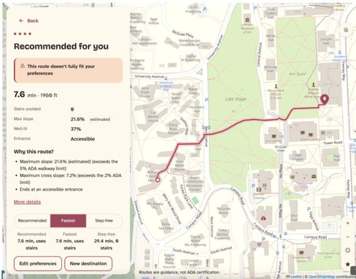
Results for Path
-
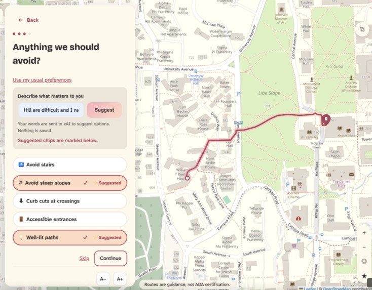
Using XAi
-
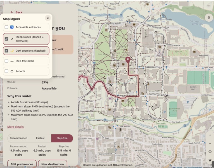
Showing Markers
-
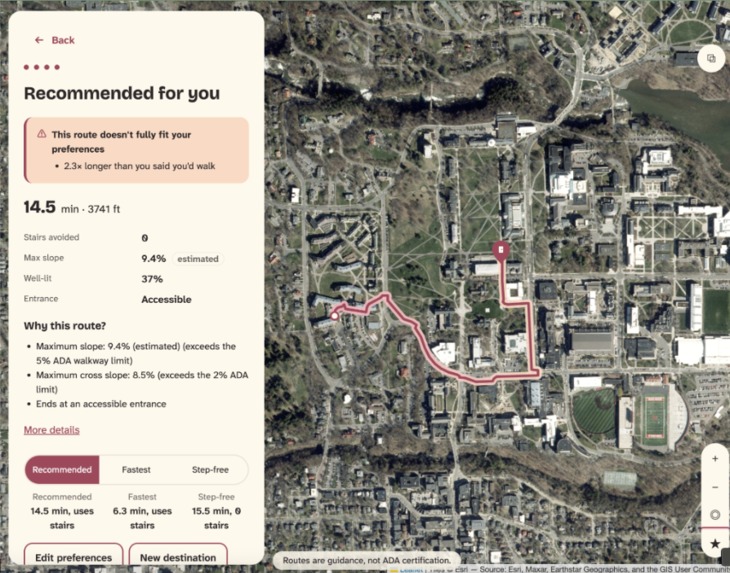
Realistic Map
-
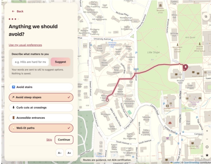
Route w/ Preferences
Inspiration
Every map app answers one question: what's the fastest way there? For many people, that's the wrong question.
This is personal for our team. We've had nights when getting there in a way we felt comfortable mattered more than getting there fast: walking home alone after dark, or crossing campus on an icy slope. We've also watched friends and classmates with injuries and disabilities follow a map built for convenience rather than accessibility. They reach the bottom of a staircase the app never mentioned, backtrack across a hill, or arrive at an "accessible" building only to find the door behind steps. The map didn't just slow them down; it left them out.
At Cornell, the fastest route from West Campus to the Arts Quad climbs the stairs on Libe Slope. That's fine for some walkers, impossible in a wheelchair and miserable on crutches in the snow. About 1.3 billion people worldwide live with a significant disability (WHO), and countless more are injured, carrying something heavy, or walking alone at night. Yet maps route all of them the same way.
What it does
Way2Go is walking navigation for Cornell's central campus that routes around your needs.
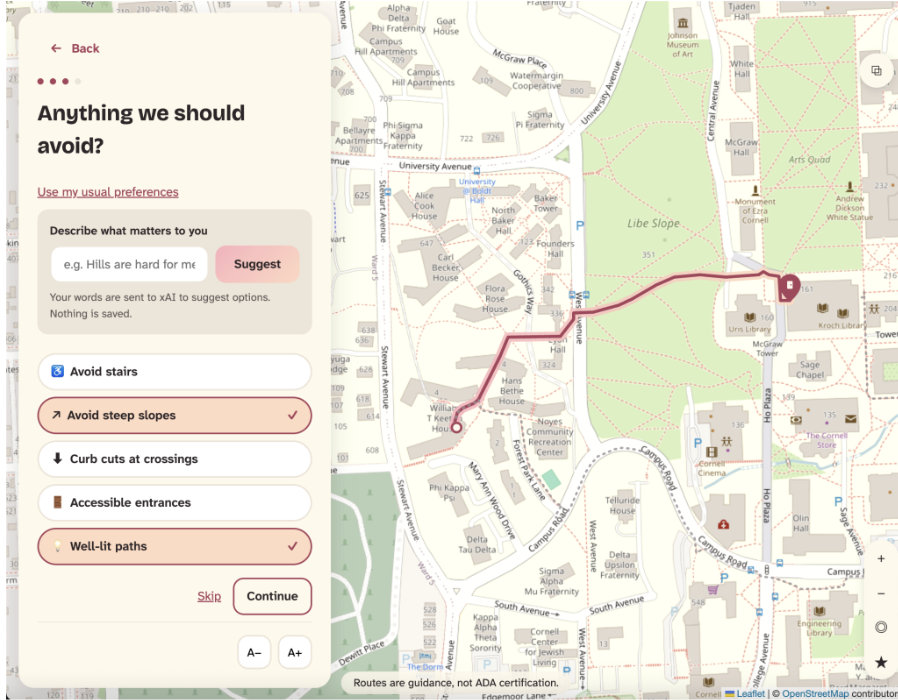
- Choose what matters to you: avoid stairs, avoid steep slopes, curb cuts, accessible entrances or well-lit paths, each marked Essential, Important or Nice to have.
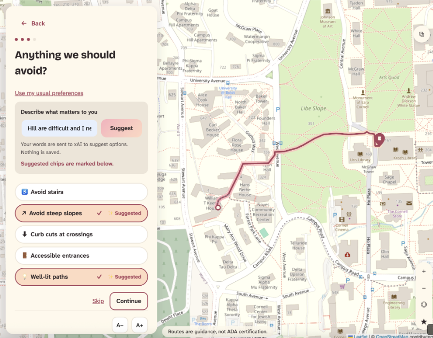
- Or just describe it: type "hills are hard for me and I don't mind walking farther." xAI turns that sentence into suggested preferences you can edit before routing. AI never computes the route itself.
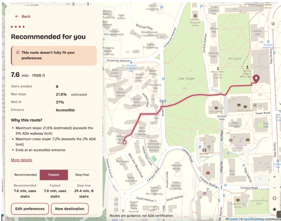
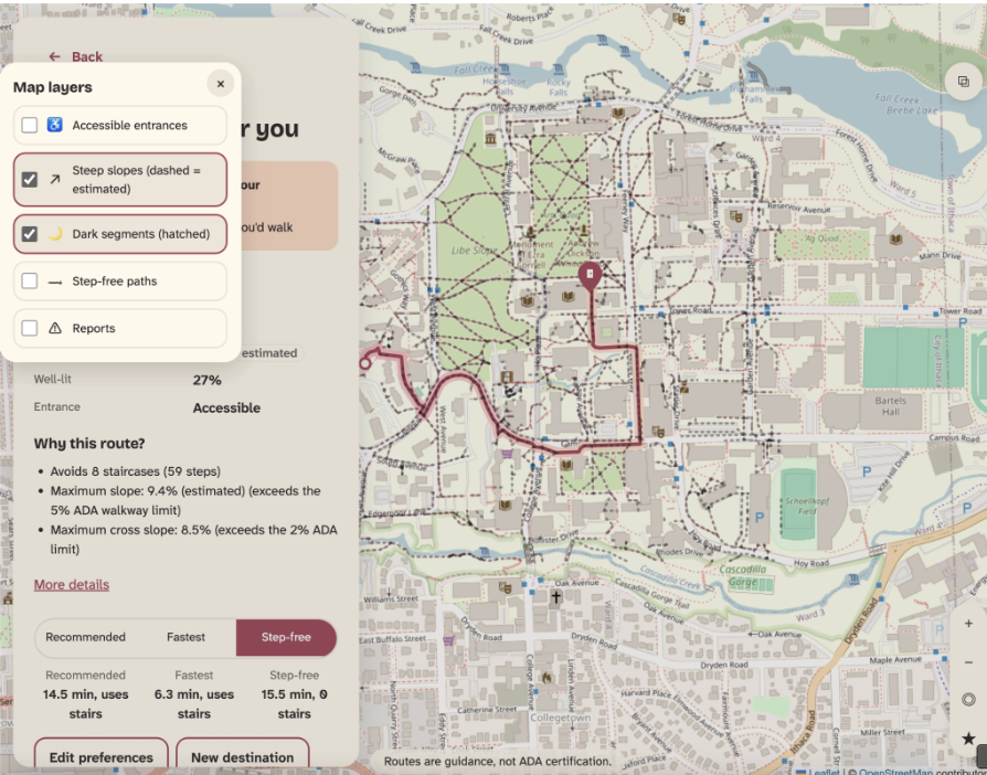
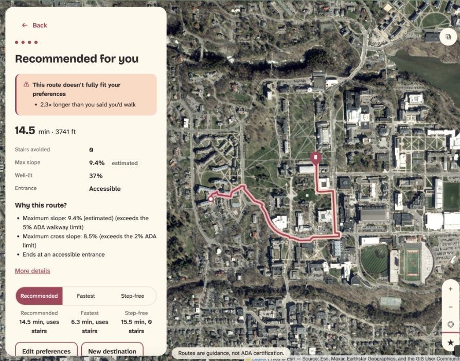
- See why each route was chosen: every route explains itself against ADA standards ("Avoids 59 steps," "Max slope 9.4% (estimated)"). Lidar-based estimates are always labeled as estimates.
- Same trip, different person: Keeton House to Goldwin Smith Hall is 1,960 ft for the fastest walker. A fully step-free route is 7,551 ft, nearly 4× longer.
- Map layers: toggle accessible entrances, steep slopes, dark segments, step-free paths and reported obstacles right on the map.
- Night and ice awareness: after sunset Way2Go favors well-lit paths, and in freezing weather it penalizes steep slopes more heavily.
- Optional sign-in: an email link saves your preferences. Everything works without an account, and one tap deletes your data.
How we built it
- Real campus data: seven Cornell Facilities GIS layers covering sidewalk slope, cross slope, width, surface, crosswalk curb cuts, entrances, stairs and light fixtures.
- A routing graph from scratch: in Python (geopandas, shapely, networkx) we joined a fragmented sidewalk network into 4,070 nodes and 6,092 edges, with 95% connected and 326 accessible entrances attached. We filled in 320 unsurveyed slopes using USGS 1-meter lidar and labeled every one as an estimate.
- Personal routing: a FastAPI service separates hard limits (things you can't do) from penalties (things you'd rather avoid). It adds sunset times and National Weather Service conditions, and when no route fully fits your needs, it says exactly which rule it broke.
- Supabase: Postgres + PostGIS for reports and saved preferences, with Row Level Security on every table and triggers that round report locations to about 10 m.
- xAI: turns plain language into preferences. Its output is validated against allowed values before the user ever sees it.
- Frontend: a map-first web app (Leaflet + OpenStreetMap) using Atkinson Hyperlegible, a typeface designed for low-vision readers, with full keyboard and screen-reader support.
- How we worked: we planned with Claude and built with Claude Code from structured prompts, with a human checking every step. 130+ automated tests back it up.
Challenges we ran into
- Messy Data: the sidewalk network was badly disconnected, and stairs were stored as shapes rather than paths. We rebuilt the pipeline against Cornell's real schema overnight.
- Caution: to guarantee step-free routes never touch stairs, we flagged 718 segments as stairs. That cut off 28 "accessible" doors that sit beside steps. We kept the cautious rule.
- Estimates: an early step-free route climbed a 15% lidar-estimated slope while reporting no problems. Now estimated slopes over 10% block step-free routing.
- Logistics: generated data that doesn't live in git, merge conflicts, a map provider that suddenly required API keys, and AI usage limits running out mid-build.
Accomplishments that we're proud of
- Routing on surveyed cross slope, curb cuts, width and entrance access, data that mainstream map apps don't route on.
- Explanations users can check, with estimates always labeled.
- Privacy from day one: we store routing preferences, never disability labels; locations are never stored; reports are anonymous.
- A real finding about campus: our barrier analysis found that in 83% of 2,000 sampled trips between accessible entrances, no step-free route exists within 1.5× the shortest path.
- We validated our model and pipeline with thousands of tests
What we learned
- Accessibility breaks like a chain. One missing curb cut or one set of stairs can make a whole trip impossible. Fixing Cornell's top 5 barriers would unblock only about 4% of trips, because most routes hit several barriers in a row.
- "Accessible" isn't the same as reachable. A door can be labeled accessible and still sit behind steps. The building passes the checklist while the person still can't get in.
- The detour is the hidden cost. A 7-minute walk becomes a 38-minute one. Disabled students pay for that in time, energy and pain every day, and nobody sees it.
- Missing data is part of the problem. About 30% of paths were never surveyed, so a wheelchair user often can't know whether a route works until they're already on it.
- Needs are personal, not one-size-fits-all. Someone on crutches, someone who uses a wheelchair and someone walking alone at night each need different routes, so one "accessible" toggle is never enough.
What's next for Way2Go: Every Route, Accessible Your Way
- Partner with Cornell Facilities and Student Disability Services to verify routes and use our barrier analysis to plan repairs.
- Indoor routing and elevators, so the trip doesn't end at the door.
- Voice and haptic guidance for blind and low-vision users.
- Expand to other campuses, then hospitals, transit systems and cities.
- In 100 years: navigation that knows how you move, not just where you're going, with every map working for every person by default.
Built With
- astral
- claude
- css3
- esri
- fastapi
- geopandas
- html5
- javascript
- leaflet.js
- national-weather-service-api
- networkx
- openstreetmap
- pandas
- postgis
- postgresql
- pydantic
- pyproj
- pytest
- python
- shapely
- sql
- supabase
- usgs-elevation-api
- uvicorn
- xai-grok


Log in or sign up for Devpost to join the conversation.