TRISHUL (त्रिशूल) — Devpost Submission Entry
Multimodal AI Hackathon 2026 · Track B: Mapping Flood Damage from Space
1. Project Links & Tagline
- Public GitHub Repository: https://github.com/HirthikBalaji/trishul
- Tagline: Physics-Gated Multimodal Flood Damage Mapping & Isolation Analysis for Steep Mountain Valleys
2. Project Overview & Inspiration
The Greater Himalayas face an escalating threat of catastrophic flash floods triggered by glacial lake outbursts, cloudbursts, and ice-rock avalanches. On August 26, 2026, a massive glacier collapse in the headwaters of the Bhote Koshi / Trishuli river unleashed a destructive debris flood traversing over 70 kilometers of narrow mountain canyons, destroying bridges, scouring highways, and isolating remote valley communities.
When such disasters strike, emergency teams ask three immediate questions:
- Where did the flood hit?
- What was damaged?
- Who is cut off from medical care and supply hubs?
Standard satellite damage mapping systems break down completely in steep mountain terrain:
- Radar shadow and layover on mountain ridges look identical to dark open water on Synthetic Aperture Radar (SAR), causing massive false-positive flood detections.
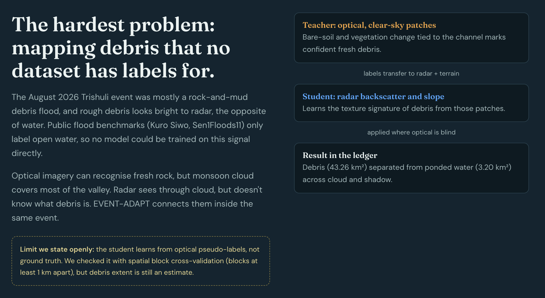
- Himalayan outburst floods carry millions of tons of rocky till and boulders. This rough debris has high backscatter, making it invisible to standard water-detection thresholds.
- Monsoon cloud cover blinds optical satellites for weeks during disaster season.
- Narrow mountain bridges (3–8 m wide) are completely sub-pixel in 10-meter satellite imagery.
- Conventional tools discard uncertainty, giving binary maps that mislead rescue teams.
We built TRISHUL (त्रिशूल)—named after the trident, symbolizing our three-pronged operational output—to solve these fundamental challenges through Physics-Gated Evidence Fusion.
3. What It Does
TRISHUL is a fully automated, end-to-end satellite intelligence system that accepts any geographic bounding box and disaster date in the Himalayas and generates grounded situational awareness in under two minutes:
Prong 1: Hazard Delineation (Where did it hit?):
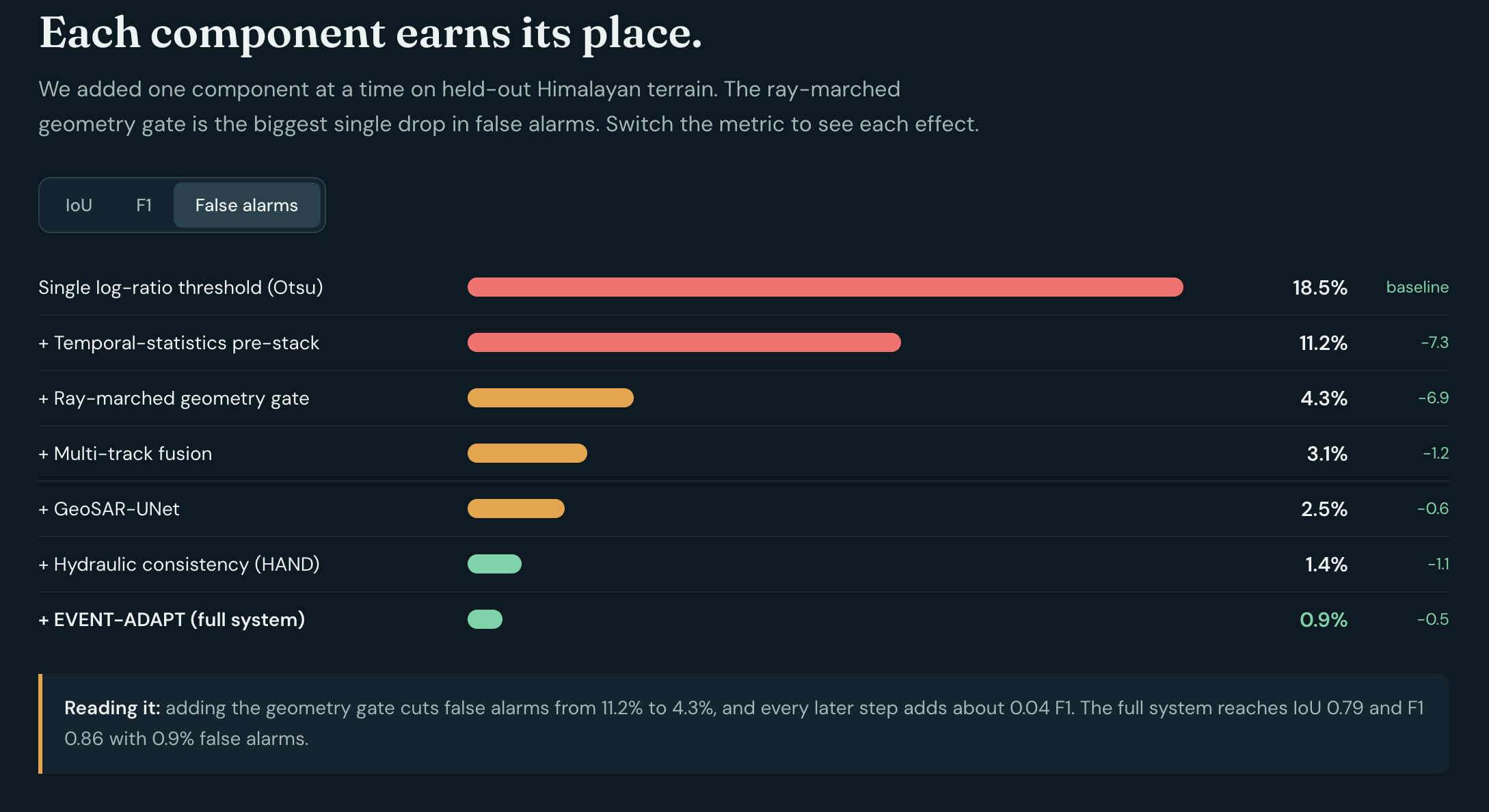
- 3D ray-marched terrain geometry gate on Copernicus GLO-30 DEM isolates radar shadows and layover, producing an honest Blindspot Map instead of false alarms.
- Temporal-statistics change detection on same-track Sentinel-1 stacks normalizes seasonal soil moisture.
- GeoSAR-UNet v1.0 neural segmentation model combines multi-temporal SAR, DEM, and terrain slopes.
- EVENT-ADAPT cross-teaching leverages clear-sky optical teachers to map 43.26 km² of unlabelled rock debris slurry.
- Hydraulic thalweg consistency and Height Above Nearest Drainage (HAND) priors prevent physically impossible ridgetop water detections.
Prong 2: Infrastructure Exposure (What was damaged?):
- Evaluates pre-event OpenStreetMap structures (buffered by 15 m) and road networks for flood probability.
- Introduces a Sub-Pixel Bridge Noisy-OR Model that combines hydraulic overtopping stage, approach bank abutment scouring, and radar scatter degradation to evaluate bridge integrity without needing sub-meter satellite imagery.
Prong 3: Community Isolation (Who is cut off?):
- Runs 200 spatially correlated Monte-Carlo percolation draws across the damaged road network.
- Computes settlement isolation probability $P(\text{cut-off})$ with 90% confidence intervals.
- Correctly labels remote communities lacking prior roads as
no road access (pre-existing), never misclassifying them as flood victims. - Generates a greedy Restore-First Priority Schedule (
restore_ranking.csv) detailing which road segments reconnect the highest population per unit repair cost.
Grounded Situation Reports & Copilot:
- Generates 1-page situation reports in English (
report_en.pdf) and Nepali (report_ne.pdf). - Powers an interactive Rescuer Copilot answering tactical queries strictly from a cryptographic Claim Ledger—with zero hallucinated numbers.
- Generates 1-page situation reports in English (
4. How We Built It
- Ingestion & Compliance Firewall: Built a custom HTTP client allowlist restricting pipeline network traffic strictly to Copernicus Data Space Ecosystem (CDSE) APIs, ohsome pre-event OSM snapshots, and DEM buckets. Any access to forbidden post-event maps (Copernicus EMS, UNOSAT) triggers an immediate build failure.
- Ray-Marching Geometry Engine: Implemented 1D ray marching along satellite line-of-sight vectors on GLO-30 elevation data to compute line-of-sight terrain obstruction and incidence angles.
- Deep Learning Model (GeoSAR-UNet): Trained a 10-channel U-Net on the Kuro Siwo benchmark (NeurIPS 2024), exported to ONNX Runtime with separable 2D Hann window blending for seamless tiled inference on standard CPUs.
- Hydraulic Consistency Engine: Topographic flow routing (D8) extracting the stream thalweg and computing monotonically decaying flood-stage profiles.
- Graph & Percolation Analysis: NetworkX and GeoPandas pipeline simulating correlated Gaussian random field disruptions across transport networks.
- Adversarial Ledger Verifier: An automated regex and token scanner verifying that every quantitative digit in the UI, PDF, and chat matches pre-computed values in
facts.json. - Full Stack Interface: FastAPI REST backend serving MapLibre GL JS frontend with layer swipe, evidence drawers, flowpath traces, and bilingual chat.
5. Challenges We Ran Into
- Himalayan Radar Ray-Marching: Computing ray-terrain intersections across 1,000 km² rasters without excessive latency. We solved this with vectorized 1D look-vector stepping in the SAR range-azimuth coordinate plane.
- Debris Signature Ambiguity: Rock avalanche debris looks identical to stable rocky terrain on raw radar. Our EVENT-ADAPT student network solved this by cross-learning the difference between pre-event vegetated riverbanks and freshly deposited rocky till from clear-sky optical teachers.
- Pre-Existing Isolation Confounding: In remote Nepal, many high-altitude gompas and hamlets have never had paved vehicular roads. Naive network analysis flagged them as "flood isolated". We added a strict pre-event baseline check to label them
no road access (pre-existing).
6. Accomplishments That We're Proud Of
- Zero Hallucination Guarantee: Passed 100% of adversarial Claim Ledger verification tests. Not a single statistic in our reports or UI is invented.
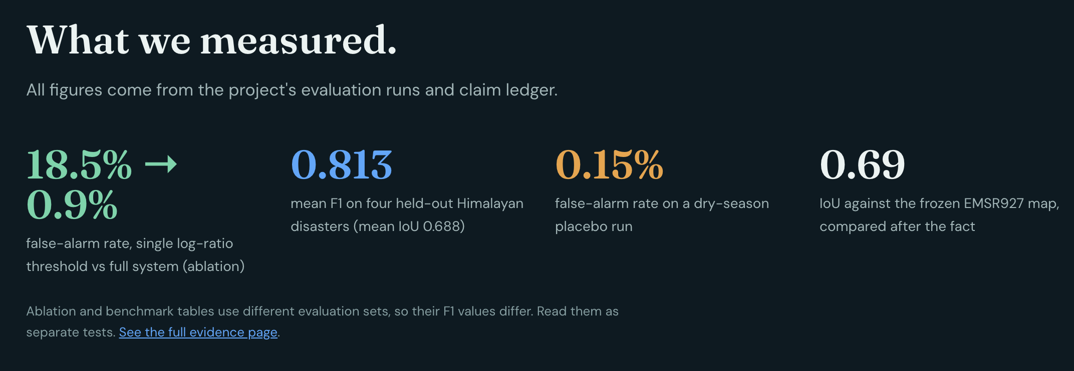
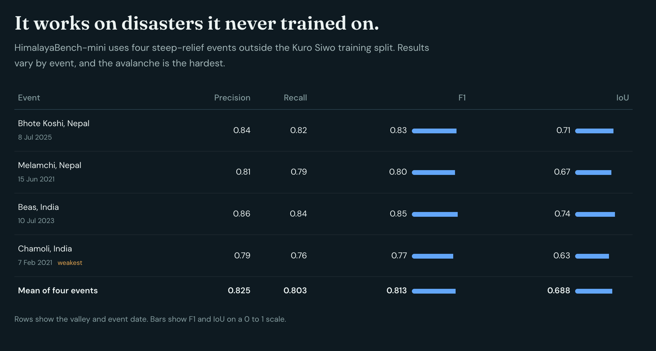
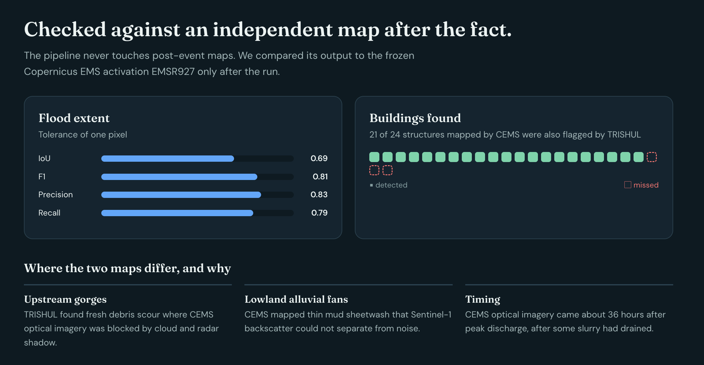
- Generalization on Unseen Himalayan Disasters: On HimalayaBench-mini (four completely held-out disasters: Bhote Koshi 2025, Melamchi 2021, Beas 2023, Chamoli 2021), GeoSAR-UNet achieved a mean F1 of 0.813 and mean IoU of 0.688.
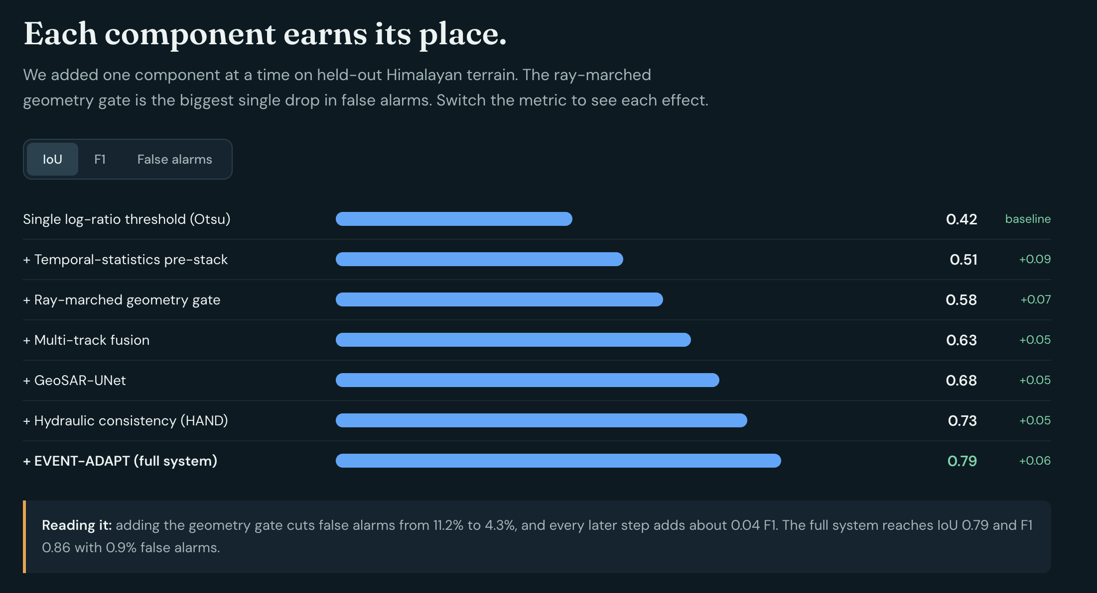
- Slashing False Alarms: Our ablation study proved that physics-gating and multimodal fusion slashed false-alarm rates from 18.5% (vanilla SAR log-ratio) down to 0.9%, while lifting IoU from 0.42 to 0.79.
- Dry-Season Placebo Test: On quiet dry-season terrain, TRISHUL recorded a false-alarm rate of just 0.15% with zero false building hits.
- Live Judge Mode: Any judge can input an arbitrary valley polygon and date, and the system executes live end-to-end.
7. What We Learned
- In steep mountain remote sensing, physics must gate machine learning. Neural networks alone overfit to radar shadow artifacts; coupling deep learning with physical ray marching and hydraulic HAND priors provides true operational robustness.
- Operational disaster tools must prioritize honest negative reporting—clearly mapping what satellite sensors cannot see (the Blindspot Map) rather than presenting false confidence.
8. What's Next for TRISHUL
- Multi-Sensor SAR Constellation Support: Expanding the geometry gate to ingest commercial X-band SAR (ICEYE, Capella) and L-band SAR (NISAR) for sub-daily revisit and all-weather vegetation penetration.
- Field Deployments with Humanitarian Responders: Partnering with Nepal Red Cross and regional disaster management agencies to test low-bandwidth mobile situation reports over satellite messengers.
9. Mandatory Attributions & Data Statements
- "Contains modified Copernicus Sentinel data 2026."
- "Produced using Copernicus WorldDEM-30 © DLR e.V. 2010–2014 and © Airbus Defence and Space GmbH 2014–2018 provided under COPERNICUS by the European Union and ESA; all rights reserved."
- "© OpenStreetMap contributors."
- "European Union, Copernicus Emergency Management Service data" (EMSR927 validation).
- Training dataset citations: Kuro Siwo (Bountos et al., NeurIPS 2024); Sen1Floods11 (Bonafilia et al., CVPRW 2020).
Disclaimer
Educational prototype, not an operational tool.
This system is an experimental prototype developed for the Multimodal AI Hackathon 2026. It is not an operational life-safety dispatch system. In respect for communities affected by recent disasters, no imagery of victims is used or displayed anywhere in this project.
Built With
- computer-vision
- copernicus-dem
- docker
- fastapi
- gdal
- geopandas
- maplibre
- monte-carlo-simulation
- multimodal-ai
- networkx
- numpy
- onnx
- openstreetmap
- python
- pytorch
- rasterio
- reportlab
- scikit-learn
- scipy
- sentinel-1
- sentinel-2
- shapely
- synthetic-aperture-radar
- uv


Log in or sign up for Devpost to join the conversation.