-
-
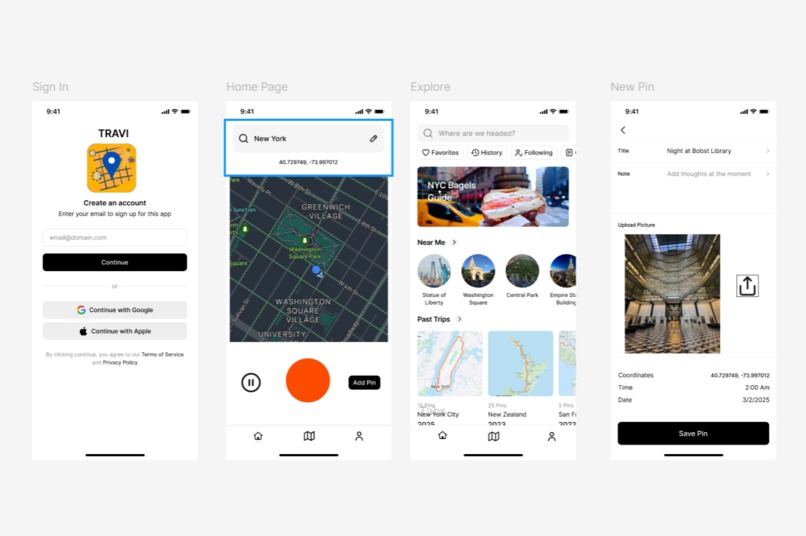
Travi Mobile App design (Sign-in, home, explore and create pin page )

Inspiration
Much of modern successful user-driven apps are centered around social interactions, sharing, and logging bits of our lives for the world to see. Our app aims to achieve a similar goal to the exercise logging app Strava, and therefore inspired by it, but instead it tracks your entire route during a trip or vacation.
What it does
The app will be built around users logging their trips and sharing them with their friends, connected to social media via easily shareable graphics and links. It has two main features: one is tracking the overall GPS route during the trip, and the other is adding dynamic location pins where you can log a note, a restaurant review, thoughts and share memories via pictures or videos at a specific location.
How we built it
We built a mock-up of the application UI/UX design using figma where we have a simple design that directly takes the user directly to a “record trip” start screen. Other pages include a location pin logging function and an explore page function. Both being beginners to Build Athens (this being our first), we had limited app development experience. But we were able to use javascript, html and css with the leaflet api to build the foundational interactive map that we will use for our application. The app tracks the user’s current location every 10 seconds, updating the route and connecting each point together. The user can also click on any point to add a pin and a note message.
Challenges we ran into
We ran into a lot of problems and challenges during the development of the app, as we hit a lot of dead-ends, figuring out potential paths to making this work. I originally explored React extensively to use its geo-location features for GPS tracking, and we explored deploying the app to mobile devices to Expo. Furthermore, I explored options using a Strava API with the Postman api platform, only to realise the recent Strava api restrictions that would make this very difficult.
Accomplishments that we're proud of
Finally, we landed on using the javascript library leaflet for the interactive map, and ORSM for a simple route tracking device. We are very proud to have come to a solution and a working interactive map despite all the difficulties and challenges. And furthermore, we are very proud of the app design and concept itself. We think that the app is a creative and exciting concept that could actually be used by real life people—ourselves and our peers.
What we learned
Needless to say, despite the simplicity of the application presented, a lot of work and learning went on behind the scenes as a part of our trial and error, we learned the ins and outs of app development through React and React native. I learned a lot about APIs, how to use them and how to access them through the Postman interface. My partner explored the Leaflet javascript libraries. And we definitely both sharpened our skills in javascript.
What's next for Travi - Travel Tracker & Sharing App
In the future, we plan on adding more features and fully integrating this with React, which we began as of now. We also plan on developing the sharing, and social networking system of the app, which will be integral to its success.And the pin feature will be the most stand-out features of this application. We plan to make this into a dynamic, exciting feature that includes written notes, links to google map restaurants and venues, photo and video sharing features, and more. We’ve also identified potential monetization potential with sponsors and advertisement on the explore page given which region the user is travelling to. These are all things we wish to continue to work on in the future as we think the app holds fun and exciting concepts that we would like to explore further.

Log in or sign up for Devpost to join the conversation.