-
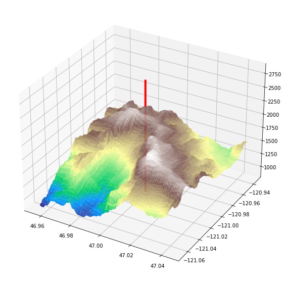
a terrain plot surrounding a set of coordinates
-
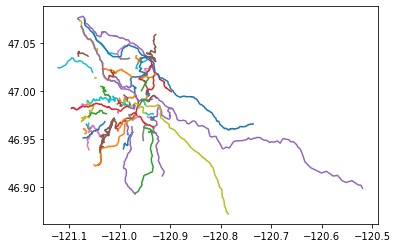
All the trails around a set of coordinates

Inspiration
Growing up in Seattle, it was always clear to me that outdoor trips and the national parks service were tied closely to the cause of environmentalism. To appreciate and protect nature, people need to see it! This project was a way to make the process of accessing new areas by trail more streamlined.
What it does
It plots a 3D terrain map of the area around an input set of coordinates, marking this point on the map. It also plots all the trails and routes around this area. The size of the area can be changed, as can the resolution and the length of trails to consider.
How we built it
The entire project runs on python. Open street map is used to get trail information and the open elevation API to get the terrain data. All the plotting was done on matplotlib.
Challenges we ran into
A lot of the hackathon was spent without a clear project focus. Additionally, the speed of this program is limited by the requests we make to open street map and the elevation API, along with the processing of their results.
Accomplishments that we're proud of
A successful 3d rendering of the terrain and a map of the trails around too!
What we learned
Working with different APIs quickly and ways to present data.
What's next for Trail Planner
Firstly, projecting the trails onto the 3D terrain map and adding interpolation to the surface shouldn't be much extra time. Optimizing the requests and subsequent processing of OSM and elevation data to allow higher resolutions. Finally, putting this all on a website with an interactive map would allow for fun accessible exploration of the tool!
Built With
- openelevation
- openstreetmap
- python

Log in or sign up for Devpost to join the conversation.