Inspiration
Proverse was inspired by the need to address key community issues like traffic congestion, land pollution, and drainage problems through real-time, data-driven solutions. The idea arose from a desire to create an easy-to-use platform that empowers citizens to engage with their environment and solve problems using cutting-edge technologies such as AI, GIS, and voice commands.
What it does
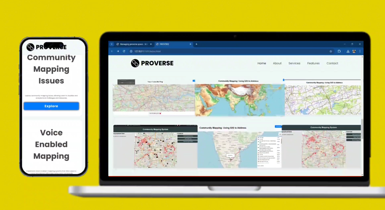
Proverse is an interactive community mapping system that enables users to explore and analyze various community issues. It features:
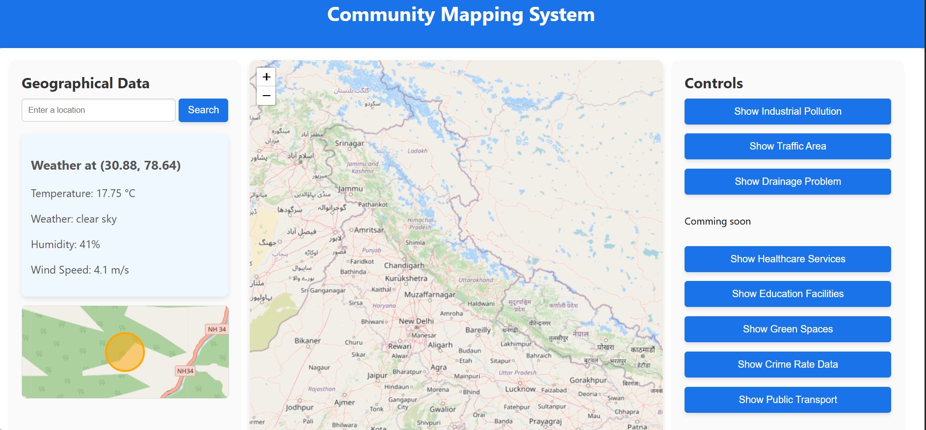
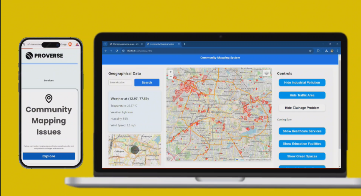
- Dynamic Maps with Multiple Layers: Users can toggle between views of traffic congestion, pollution zones, drainage issues, and custom geospatial data visualizations.
- Voice-Controlled Navigation: Proverse allows voice commands for map interactions, including location searches, routing, and requesting data on specific issues.
- Real-Time Weather Data: Users can view up-to-date weather conditions for any mapped location, with a mini-map overlay showing current temperature and weather status.
- Routing and Directions: Proverse calculates optimal routes using the Leaflet Routing Machine, providing turn-by-turn directions to multiple locations.
- Mobile-Responsive Design: The platform adapts seamlessly across devices, ensuring accessibility on desktop, tablet, and mobile.
How we built it
We used a combination of modern web development tools and APIs to create Proverse:
- Frontend: Developed using HTML5, CSS3, and JavaScript. For interactive maps, we leveraged Leaflet.js, while GeoJSON was used to visualize geospatial data related to community issues.
- Voice Control: The SpeechRecognition API was integrated to allow voice-based map interactions, and Text-to-Speech (TTS) was implemented for audio feedback.
- Weather Data Integration: We utilized the OpenWeatherMap API to fetch real-time weather information based on user location, which is displayed directly on the map.
- Routing and Directions: The Leaflet Routing Machine was incorporated to calculate the best route between two or more points on the map.
- Mobile-Responsive Design: Bootstrap was used to ensure that the application is fully responsive and optimized for various screen sizes.
- Development Environment: The project was built using Node.js for server-side development, with dependencies installed via npm.
Challenges we ran into
- Integrating Voice Control: Initially, there were challenges with ensuring smooth interaction between voice commands and the map's various functionalities. Fine-tuning the SpeechRecognition API and TTS for accurate responses was a time-consuming process.
- Weather Data Accuracy: The integration of real-time weather data from OpenWeatherMap had its own set of challenges, especially in ensuring accurate location mapping and updating weather information dynamically as the user navigates.
- Responsive Design: Ensuring the platform was optimized for mobile, tablet, and desktop users while maintaining functionality across different devices required a lot of tweaking, particularly in the map's presentation and the sidebar controls.
- Layer Management: Handling multiple layers of geospatial data without overwhelming the system or the user interface was a complex issue, as too many features could slow down the app.
Accomplishments that we're proud of
- Seamless Voice-Control Integration: One of the key accomplishments was successfully integrating voice commands to control the map, which enhances user interaction and accessibility.
- Real-Time Data Visualizations: We are proud of how we’ve brought together live data, including weather and traffic conditions, to provide an up-to-date view of the community environment.
- Mobile Responsiveness: The app's ability to maintain a responsive design across all devices is another major achievement, allowing users to access the platform seamlessly, whether on a desktop or mobile device.
- Comprehensive Mapping Tool: Proverse successfully combines multiple data sources, including traffic, pollution, and weather, into an intuitive platform that addresses real-world problems in an interactive way.
What we learned
- API Integration: We learned how to effectively integrate third-party APIs like OpenWeatherMap and SpeechRecognition to enhance the functionality of the platform.
- Voice Recognition: Working with voice recognition and TTS systems taught us how to build more interactive, hands-free experiences for users.
- Geospatial Data Management: Handling and visualizing geospatial data with Leaflet.js and GeoJSON was a valuable learning experience in terms of both performance optimization and user interface design.
- User Experience Design: We gained a deeper understanding of how to design an application that’s not only functional but also accessible and easy to use, especially when dealing with complex data visualizations.
What's next for Proverse
- Expansion of Data Layers: We plan to incorporate more data layers to cover additional community issues like crime rates, healthcare facilities, and environmental changes.
- AI and Machine Learning: Future versions of Proverse may use AI and machine learning to predict trends, such as forecasting traffic patterns or pollution levels.
- Integration with More APIs: We aim to integrate with more real-time data sources, like public transportation and social services, to provide users with a comprehensive tool for community planning.
- User Contributions: We will explore ways to allow users to contribute their own data and insights, creating a more collaborative and dynamic platform.
- Global Expansion: Currently focused on local community issues, we plan to extend Proverse to global cities to address worldwide environmental and infrastructure challenges.
Built With
- bootstrap
- css3
- geojson
- git
- github
- html5
- javascript
- leaflet-routing-machine
- leaflet.js
- node.js
- npm
- openweathermap-api
- speechrecognition-api


Log in or sign up for Devpost to join the conversation.