-
-
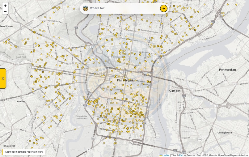
Every open pothole report in Philly, live from 311 — before you even plan a trip
-

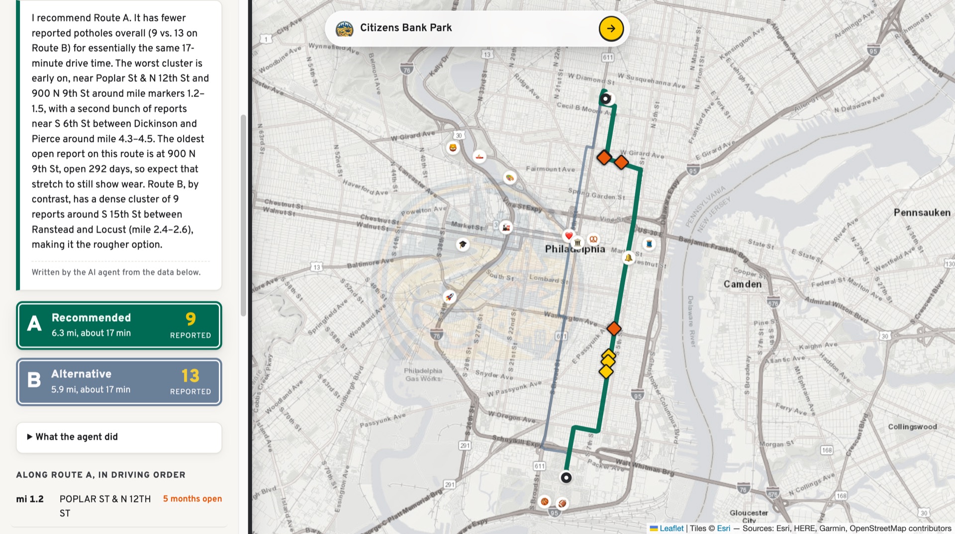
The agent's pick, explained: Route A with 9 reported potholes vs 13 on Route B
-
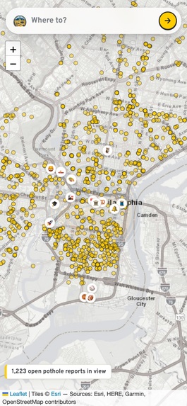
Map-first mobile UI — installable as a PWA
Inspiration
Philadelphia publishes every 311 request since 2014 — about 5.9 million rows of open civic data — and almost nobody can use it. Answering a real question takes SQL skills and knowledge of the dataset's quirks (NULL zip codes, open cases with no close date, categories that changed names). Meanwhile, in 2026 roughly 19% of pothole reports are still sitting open, averaging 27 days to close. The data to drive around them exists, live, for free. It just needed an agent in front of it. And it's Philly, so obviously it's called potholejawn.
Here's the gap: no navigation app actually routes you around potholes. Waze lets users pin them and warns you as you approach — but its router only cares about travel time, so it drives you straight through a cratered block at full speed. Google patented road-quality routing in 2015 and never shipped a "avoid rough roads" toggle. Boston's Street Bump detected potholes for public works, not for drivers. potholejawn picks the route with fewer potholes and tells you why.
What it does
potholejawn is a Waze-style map for pothole avoidance. You type where you are and where you're going in Philadelphia. An AI agent geocodes both places, fetches the driving route plus alternatives from OSRM, runs a PostGIS query against the city's live 311 API for open "Street Defect" reports within 30 meters of each route, weighs pothole count, report age, and drive time, and recommends the smoother drive — with every reported pothole plotted on the map and a plain-language briefing explaining the pick.
Real example from live data: Temple University to Citizens Bank Park. Same 17-minute drive; one route passes 9 open pothole reports, the other 13.
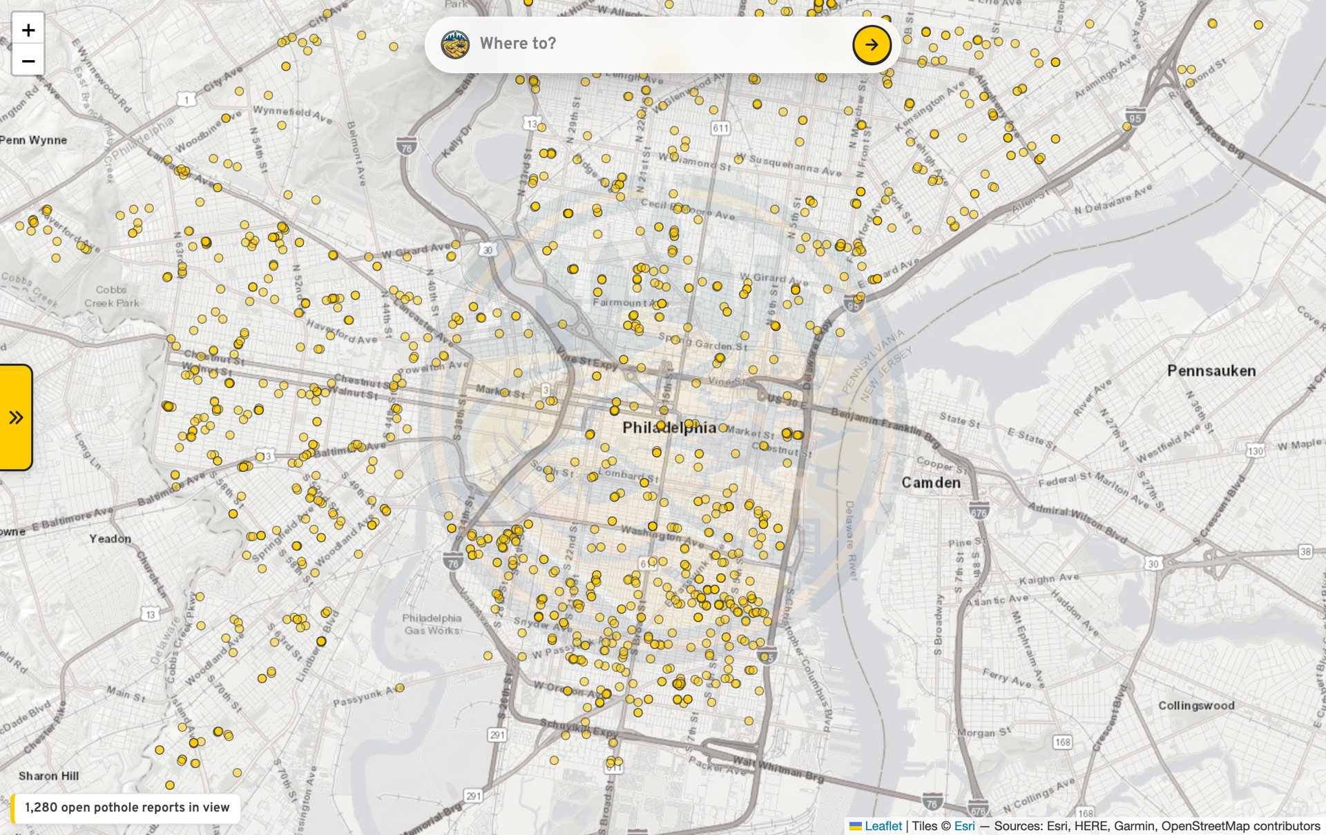
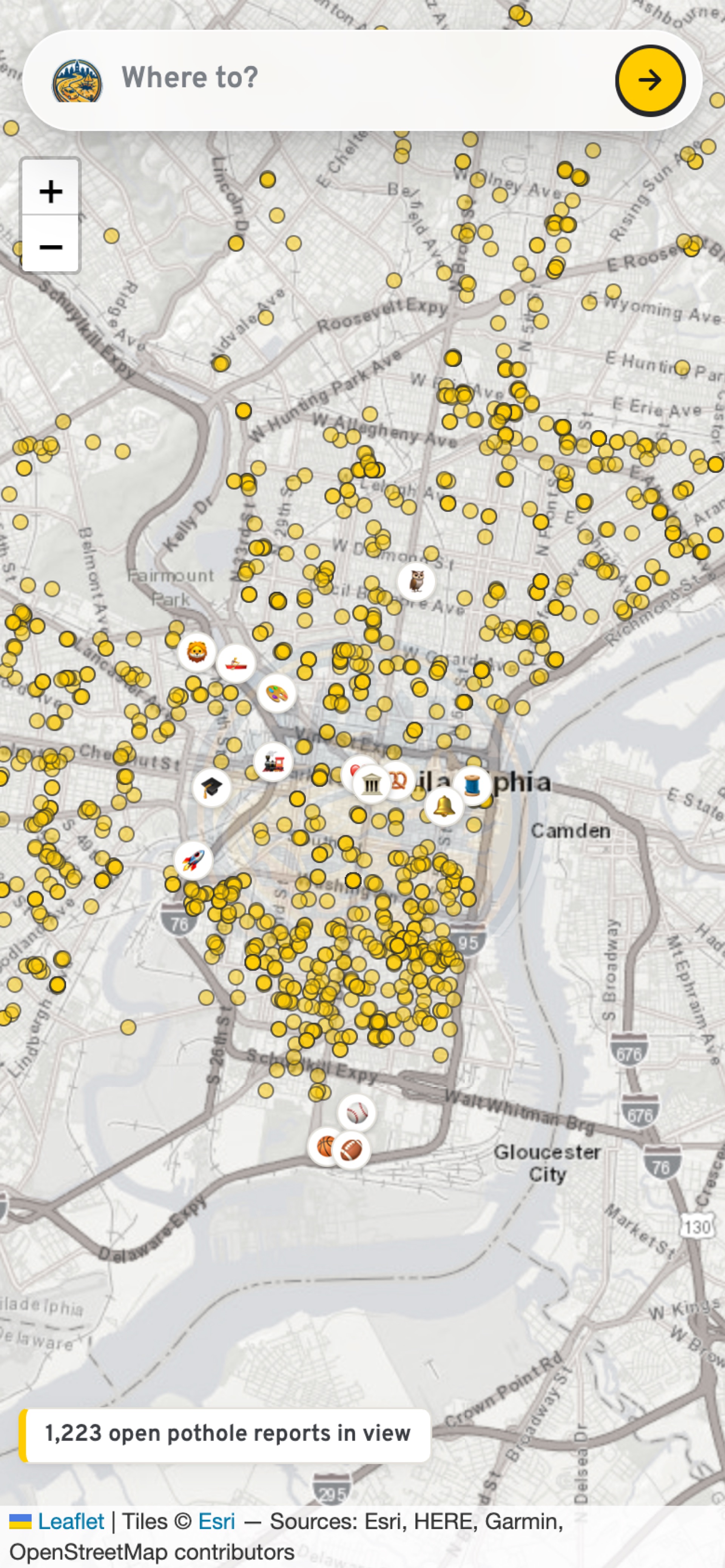
Before you even plan a trip, the map lights up with every open pothole report in view — 1,500+ across the city, live from 311, each clickable. Start typing and it autocompletes real Philly places — landmarks like the Liberty Bell or the Pennovation Center (where this was built) — or tap 📍 to route from your actual location. It's live at potholejawn.com, installable to a phone home screen as a PWA, in a map-first UI modeled on the navigation apps everyone already knows.
The repo also ships a second agent — a 311 accountability analyst — that answers open-ended questions ("where is the city slowest at fixing potholes?") right in the app or from the CLI by writing its own SQL, running it through a guardrail validator, reading errors, and retrying until it has an answer. Both agents share one generic tool loop.
Built during the hackathon (and pre-existing work disclosure)
Everything was built today, September 20, during the event window — the repository was created at 11:53 AM at Pennovation and every commit lands inside build day. That includes: both agents and the shared tool loop, the SQL guardrails, the map-first UI (desktop panel + mobile bottom sheet), autocomplete and geolocation, the citywide live-report layer, SSE streaming, prompt caching and result caching, rate limiting, 42 tests, containerization, and the production deployment to Cloud Run behind potholejawn.com.
Pre-existing work: none. No prior code, designs, or datasets were brought in. The project uses public open-source libraries (Flask, Leaflet, pytest), public APIs (Philadelphia's Carto 311 API, US Census geocoder, Nominatim, OSRM, the Anthropic API), and the domains and logo artwork were also created/purchased today during the event.
How we built it
- Agent core (
pothole_agent/agent.py): one generic tool-calling loop (run_agent) built directly on the Anthropic API — no framework. The model decides which tools to call and in what order; tool errors are returned to the model so it can self-correct; a hard 12-step limit prevents runaway loops; every thought, tool call, error, and token count is logged to a JSONL audit file per run. - Trip agent (
trip.py): four tools —geocode_address,find_routes,scan_route,recommend_route— sharing state through aTripContext. A deterministicensure_completepass scans any route the agent skipped, so the map is never half-drawn. - Analyst agent (
agent.py+tools.py):get_schema,list_categories,run_sql. It's told to state a plan, query in focused steps, and never state a number it didn't get from a query. - Data layer (
routing.py): US Census geocoder for street addresses with OpenStreetMap Nominatim fallback for landmarks (neither alone covers Philly well), OSRM for routes, and a PostGISST_DWithinquery against the city's public Carto SQL API for potholes along a route buffer. - UI (
webapp.py+ Leaflet): Flask serving a static map. Agent steps stream to the browser live over Server-Sent Events, so you watch the agent think — geocode, route, scan, recommend — instead of staring at a spinner. A "What the agent did" panel shows the full audit trail including token usage. - Cost engineering: Anthropic prompt caching on the agent loop (steps 2+ read the prompt prefix from cache at ~10% price) plus a one-hour trip-result cache, and per-IP + global rate limiting on the public deployment.
- Tests: 42 pytest tests running against a fake model client — no API key or network needed for CI.
Challenges we ran into
- The data is hostile. zipcode, address, lat, and lon are frequently NULL; zips need regex filtering (
^191[0-9]{2}$); open cases have no close date, so naive "average time to fix" numbers lie. We encoded these quirks into the agents' instructions rather than pretending the data is clean. - No single geocoder works for Philly. The Census geocoder nails street addresses and intersections but not landmarks; Nominatim is the reverse. The geocode tool chains them.
- Letting a model write SQL against a live city API is scary. We treat model-written SQL as untrusted input: a dedicated validator (
guardrails.py) enforces single-statement read-only SELECTs, a table allowlist, no comments, no admin functions (pg_sleep,pg_read_file,dblink, ...), and wraps every query in a hard 200-row LIMIT. Getting that right without breaking legitimate queries (CTEs,EXTRACT(... FROM ...)) took real care. - Demos die. Public geocoders, the OSRM demo server, and the model API can all flake. The whole system degrades gracefully — see safety, below.
- Basemap roulette. OpenStreetMap's volunteer tile servers blocked the public deployment mid-afternoon; CARTO's rasters watermark without a key now; we landed on Esri's World Street Map. Third provider's the charm.
Accomplishments that we're proud of
- True agentic design, not a script with an LLM stapled on. The agent picks its own tools and order, reads its own SQL errors and fixes them, records its route choice as structured output, and everything it does is auditable after the fact.
- The demo cannot die. If the API key is missing or the model call fails, a plain-Python fallback planner produces the same map with a simpler briefing — same result shape, honest
modeflag. If the agent skips a route, the deterministic pass scans it anyway. - Defense in depth for a one-day hack: SQL guardrails, a route-SQL path the model never touches (built in
routing.pyfrom validated numbers only, buffer clamped 10–100 m), a Philadelphia bounding-box geofence on every coordinate,textContent-only DOM insertion, Subresource Integrity pins on CDN assets, a step limit, per-IP and global rate limiting on the public deployment, and a full JSONL audit trail. - Honest framing baked in: markers are labeled resident reports, not verified potholes; the analyst is instructed to report open-case share next to any time-to-close figure and to never confuse "more reports" with "more potholes."
- 42 tests, pinned dependencies, zero lint findings, zero known-CVE dependencies — built solo in one day.
What we learned
- A minimal hand-rolled tool loop beats a framework for a hackathon: ~160 lines gives you tool choice, error-driven retry, step limits, and a full audit trail you actually understand.
- Feeding tool errors back to the model is the single highest-leverage agentic pattern — the analyst routinely writes SQL that fails on this dataset's quirks and fixes it on the next turn.
- Guardrails and graceful degradation aren't polish, they're what makes an agent demoable: the fallback planner and
ensure_completeturned "hope the model behaves on stage" into "the map always renders." - Civic open data is a goldmine wrapped in landmines; the agent's system prompt is where the landmine map lives.
What's next
- Live at potholejawn.com (and potholejawn.app) as the product home — installable as a PWA today, app stores via Capacitor next.
- A true roughness-weighted router: custom edge penalties on the street graph (weighted A*) instead of choosing among OSRM's time-optimal alternatives — tuned so one cratered block doesn't cause an eight-block detour through Philly's narrow one-way grid.
- Severity weighting with time decay: reports age out unless reinforced (Philly closes tickets on inspection, not repair, and cold patches die each freeze-thaw), plus PavePHL/StreetSmartPHL resurfacing schedules as positive weights.
- A "report a pothole" deep link to Philly 311 from any marker.
- Self-hosted OSRM with live traffic instead of the public demo server.
- Same pattern, other cities: any Socrata/Carto 311 feed can slot in behind the same agent loop.
Built With
- anthropic
- claude
- cloudflare
- flask
- leaflet.js
- openstreetmap
- osrm
- postgis
- pytest
- python
- server-sent-events

Log in or sign up for Devpost to join the conversation.