Github Link: https://github.com/DeepshikaGhale/NorthRoad-AI
Living in Northern Ontario, potholes are a recurring and costly infrastructure problem. Every winter freeze and spring thaw cycle rapidly damages roads, but detection is usually reactive—relying on citizen complaints, manual inspections, or delayed reporting.
This creates a gap between when damage happens and when it gets fixed. During that time, vehicles are damaged, safety risks increase, and repair costs grow.
We built NorthRoad AI to explore a simple idea:
What if every vehicle on the road could automatically detect potholes in real time and help both drivers and municipalities respond faster?
Instead of relying on delayed reporting, we transform everyday dashcam footage into a continuous road intelligence and safety system powered by AI.
What it does
NorthRoad AI detects and maps potholes in real time using AI-powered computer vision.
It processes dashcam or smartphone video streams and identifies road damage frame-by-frame. When a pothole is detected, the system immediately:
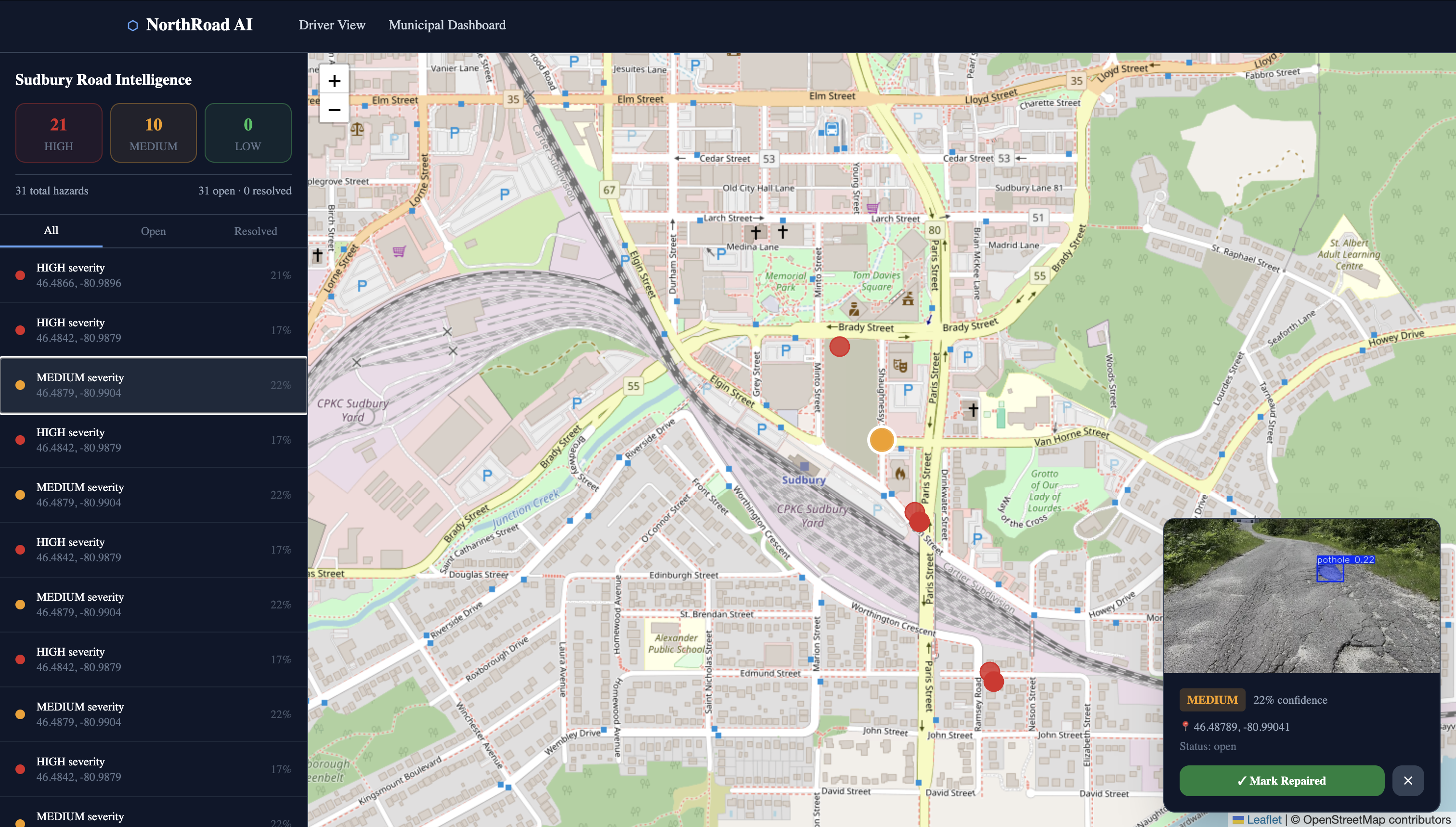
Highlights the pothole in the video stream Generates a confidence score and severity level Sends a real-time alert to drivers for immediate awareness Geo-tags the location of the pothole Updates a live municipal dashboard with road hazard data
This creates a dual-purpose system that improves driver safety in real time while also helping municipalities track and prioritize road maintenance more effectively.
How we built it
NorthRoad AI is an AI-powered road intelligence system that detects potholes from dashcam or smartphone video using real-time computer vision.
At its core, the system uses a YOLOv8-based object detection model to identify potholes frame-by-frame in video streams.
The backend is built with FastAPI, which handles video uploads and runs inference in a background processing pipeline. When a pothole is detected, the system:
Assigns confidence scores and severity levels Geo-tags the detection using GPS (or interpolated coordinates in demo mode) Stores results in a lightweight SQLite database Streams events instantly using Server-Sent Events (SSE) Displays detections on a live Leaflet + OpenStreetMap dashboard Triggers real-time driver-side alerts for immediate awareness
In parallel, annotated video frames are streamed back using MJPEG, enabling live visualization of detections as the video plays.
This creates a dual system:
Real-time driver safety alerts Municipal road condition mapping and analytics
Challenges we ran into
The biggest challenge was managing scope within hackathon constraints.
Our original vision included full fleet integration and live vehicle streaming, but we focused on building a stable and complete core system.
We prioritized:
Reliable pothole detection using YOLOv8 Real-time alert and event streaming Accurate geospatial mapping End-to-end system integration
This ensured we delivered a working system rather than fragmented features.
Accomplishments that we're proud of
Built a complete end-to-end AI system that goes from video input → detection → real-time alerts → geospatial mapping.
Successfully integrated computer vision with real-time streaming (SSE + MJPEG)
Designed a dual-output system serving both drivers and municipalities
Achieved a fully self-hosted architecture with no cloud dependency
Created a scalable pipeline that can be extended to other road hazards beyond potholes
What we learned
This project taught us that building AI systems is not just about training models—it is about designing full pipelines.
We learned how to integrate multiple systems together, including computer vision, backend engineering, real-time streaming, and geospatial visualization.
We also learned the importance of making practical engineering trade-offs—choosing simplicity and reliability over unnecessary complexity is critical when building deployable systems under time constraints.
What's next for NorthRoad AI
While the current system focuses on potholes, it is designed to be highly extensible.
In the future, we plan to expand detection to include:
Road cracks Flooded areas Fallen trees Damaged or missing road signs
We also aim to evolve NorthRoad AI into a full municipal infrastructure intelligence platform that supports:
Fleet-wide deployment across city vehicles Predictive road maintenance analytics Cross-vehicle pothole deduplication Automated repair prioritization systems
Our long-term vision is to help cities move from reactive road maintenance to proactive, AI-driven infrastructure management, while also improving real-time driver safety.
Built With
- ai-pipeline
- and-geospatial-visualization.-languages-&-core-frameworks-python-?-core-backend
- and-inference-logic-javascript-/-typescript-?-frontend-development-next.js-14-?-web-application-framework-tailwind-css-?-ui-styling-ai-/-computer-vision-yolov8-(ultralytics)-?-real-time-pothole-detection-model-opencv-?-video-processing
- backend-engineering
- fastapi
- frame-extraction
- http-file-upload
- javascript
- leaflet.js
- mjpeg-streaming
- next.js-14
- opencv
- openstreetmap
- python
- python-threading/background-workers
- self-hosted
- server-sent-events-(sse)
- sqlite
- tailwind-css
- typescript
- yolov8-(ultralytics)

Log in or sign up for Devpost to join the conversation.