-
-

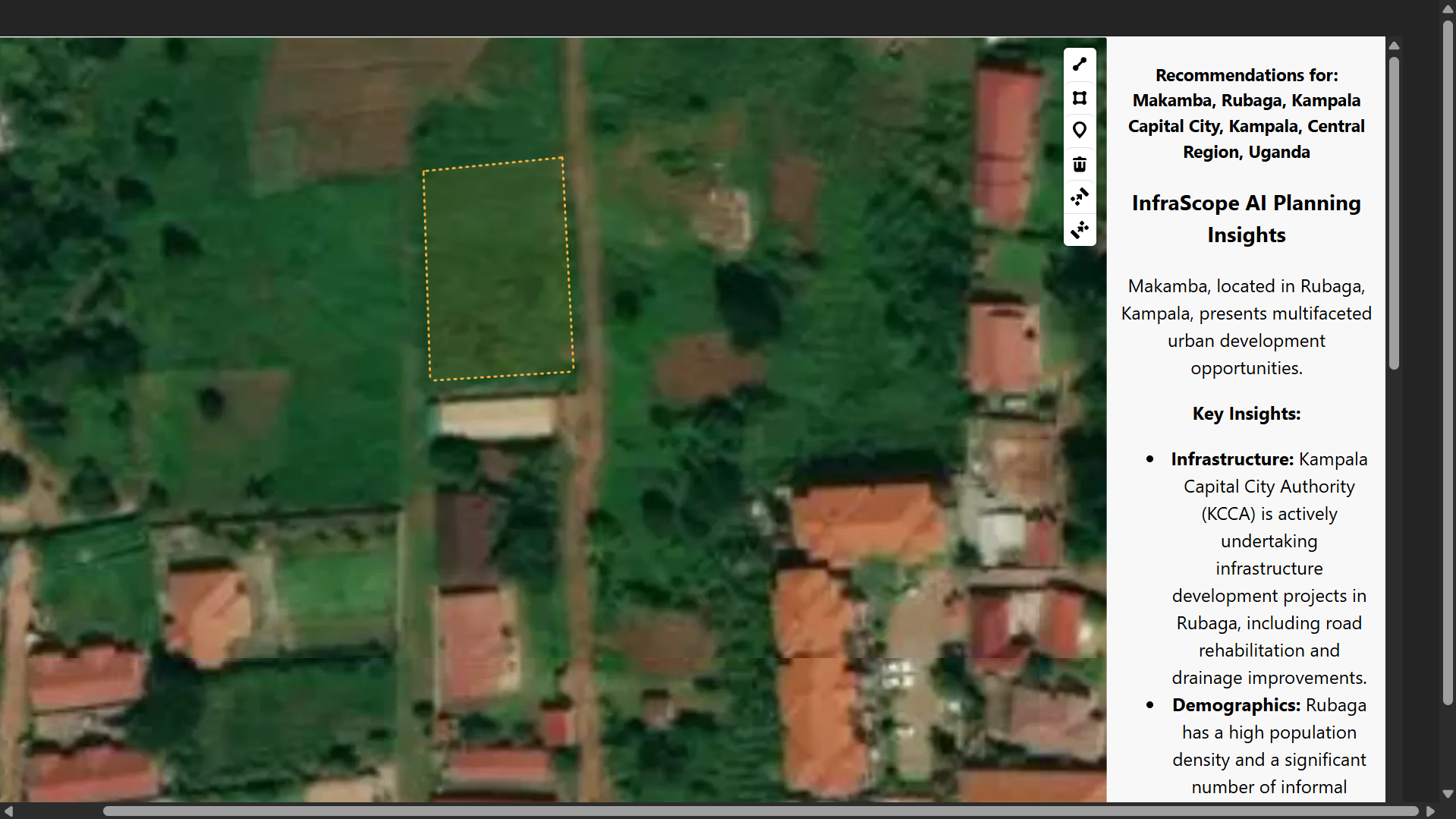
Infrscope AI Area Insight
-
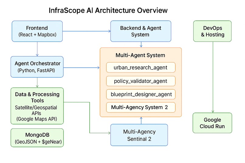
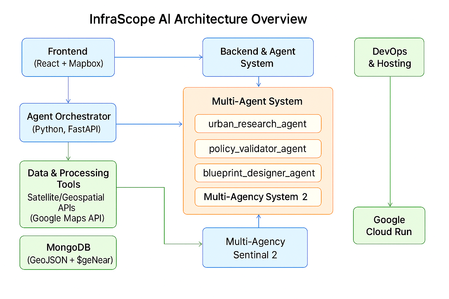
Architecture Diagram
Inspiration
What it does
🚀 Inspiration
As cities across the Global South grow rapidly, planners often face challenges of limited data, time, and capacity. Traditional planning tools don’t adapt fast enough. Inspired by the potential of AI agent collaboration, I created InfraScope AI — a smart assistant that simulates how urban experts would assess, recommend, and communicate infrastructure opportunities in real time.
🧠 What It Does
InfraScope AI automates urban planning through a multi-agent architecture built with the Agent Development Kit (ADK) and deployed on Google Cloud Run. By simply selecting a location or uploading a site boundary, users receive:
- A structured Urban Opportunity Report
- Blueprint design with optimal land allocation
- Policy validation summary based on zoning/environmental data
- Suggested visuals to support stakeholder engagement
- A final campaign brief formatted for city officials or NGOs
🔧 How It Works
Key ADK agents currently integrated include:
- 🧭 Urban Research Agent – Assesses terrain, demographics, transport, and land use
- 🏛 Policy Validator Agent – Checks compliance with local zoning and environmental overlays
- 📐 Blueprint Designer Agent – Generates text-based conceptual site layouts, including proportional land use, dimensional allocations, and implementation phases based on land context. (Visual rendering to be added in future versions.)
- 🎨 Visual Suggester Agent – Proposes descriptive visual concepts such as overlays, radii, or satellite-based comparisons tailored to stakeholder messaging. (Currently provides recommendations in text form.)
- 🗂 Campaign Formatter Agent – Compiles findings into a professional campaign brief
Each agent runs independently on Google Cloud Run, allowing scalable orchestration and fast response across locations.
🔨 Built With
- Agent Development Kit (Python)
- Google Cloud Run (for agent deployment)
- MongoDB with GeoJSON (for spatial data)
- OpenStreetMap, Google Maps API, Nominatim (for geolocation/context)
- React + Mapbox GL JS (frontend interaction)
- FastAPI (agent interface and routing)
⚙️ Challenges
- Designing meaningful agent coordination flows
- Ensuring visual outputs matched AI reasoning
- Managing real-time geospatial processing efficiently on Cloud Run
🎯 What I Learned
- How to deploy and coordinate ADK agents on scalable cloud infrastructure
- Translating expert reasoning into modular, reusable agent prompts
- Balancing smart defaults with real-world urban data
🌍 Impact Potential
InfraScope AI can empower local governments, NGOs, and urban developers to make faster, data-driven, inclusive infrastructure decisions — especially in fast-growing cities lacking planning resources.
How we built it
Challenges we ran into
Accomplishments that we're proud of
What we learned
What's next for InfraScope AI: Autonomous Urban Planning Assistant
Built With
- adk
- cloud-run
- fastapi
- gcp
- gemini
- google-geocoding
- google-maps
- mongodb
- openstreetmap
- python
- react


Log in or sign up for Devpost to join the conversation.