Inspiration
Floods can destroy homes, damage roads and bridges, and disconnect communities from essential services such as hospitals. After a flood, emergency responders need to understand not only where flooding may have occurred but also which buildings, roads, bridges, and settlements could be affected.
We were inspired to explore how artificial intelligence, satellite imagery, and geospatial analysis could help transform complex geographic data into useful information for disaster response. This led us to build FloodLens AI, a prototype designed to support flood impact assessment and infrastructure risk analysis.
What it does
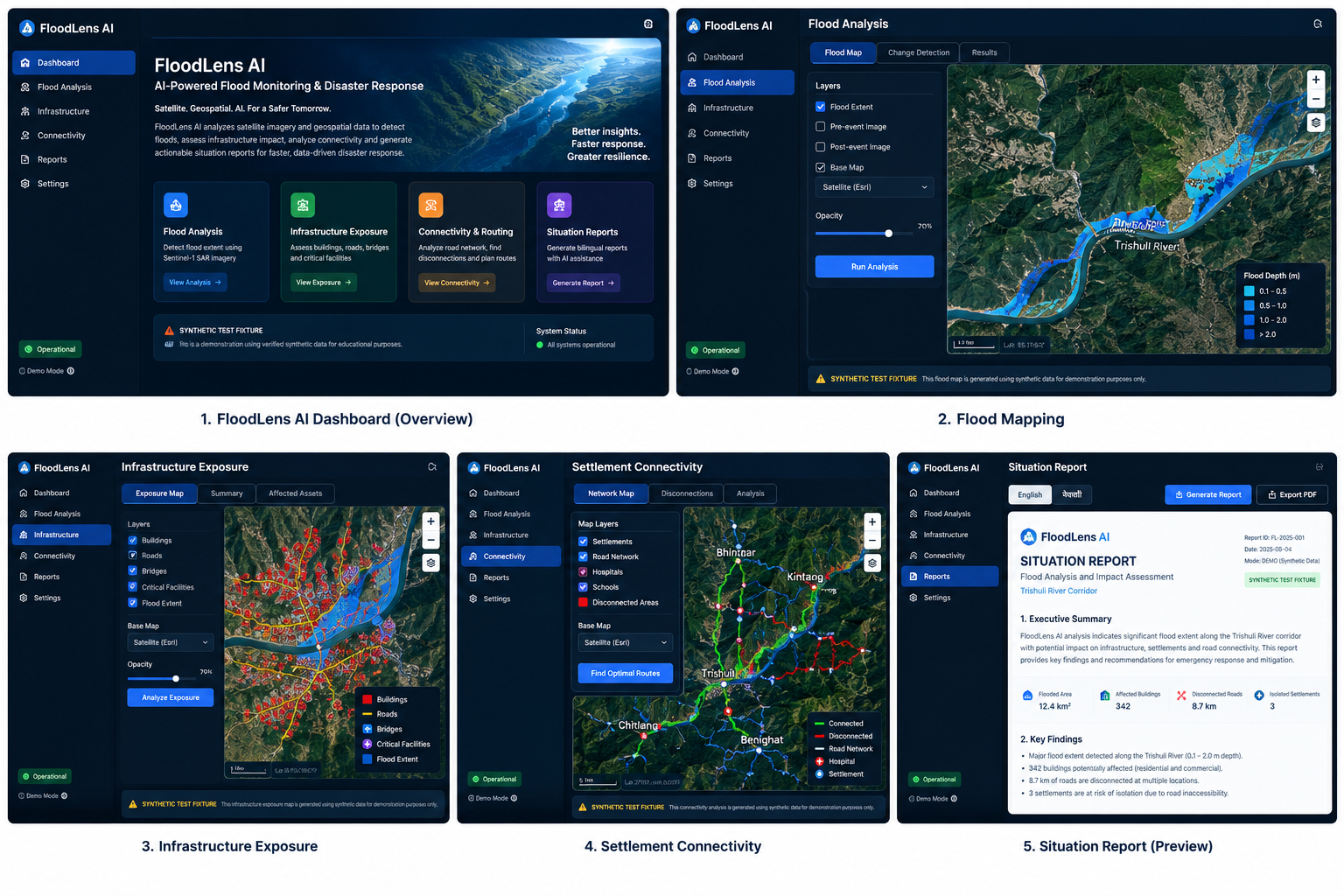
FloodLens AI is an AI-powered flood damage mapping and infrastructure analysis platform designed to help users understand potential flood impacts through an interactive geospatial dashboard.
Key features include:
- Flood Mapping: Visualizes candidate flood-affected areas and supports satellite-based flood analysis workflows.
- Infrastructure Exposure: Identifies and summarizes potentially exposed buildings, roads, bridges, and essential facilities.
- Settlement Connectivity: Examines road-network connectivity to understand how flooding could affect access to settlements and important services.
- Interactive Maps: Displays geographic information using layered maps and infrastructure overlays.
- Situation Reports: Generates structured reports in English and Nepali to communicate findings clearly.
- Report Export: Supports downloading analysis reports in PDF and Markdown formats.
- Data Provenance: Distinguishes synthetic demonstration data from other data sources so users can understand the limitations of the results.
The current demonstration uses synthetic test fixtures for its sample flood analysis. It is a prototype for demonstrating the workflow, not a verified assessment of actual flood damage.
How we built it
We developed FloodLens AI using a modern frontend, backend, and geospatial processing architecture.
Frontend: React, TypeScript, and Vite provide the interactive dashboard, map visualizations, analysis views, and report interface.
Backend: Python and FastAPI handle API requests, coordinate analysis workflows, and provide results to the frontend.
Geospatial processing: We use geospatial tools and libraries such as Rasterio, GeoPandas, Shapely, PyProj, SciPy, and NetworkX to support raster processing, geographic data analysis, and road-network connectivity workflows.
External data services: The application includes integrations for the Copernicus Data Space Ecosystem for satellite product discovery and authenticated downloads, and OpenStreetMap Overpass for infrastructure queries. Google Gemini can optionally support AI-generated situation reports.
Visualization and reporting: Interactive map layers help users explore potential impacts, while structured reports present the analysis in a more accessible format.
Deployment preparation: We prepared the application for deployment using Render for the FastAPI backend and Vercel for the React frontend.
The application also supports a demonstration mode that uses bundled synthetic fixtures, allowing the main workflow to be explored without requiring large satellite downloads or paid AI API credentials.
Challenges we ran into
One of our main challenges was bringing together multiple types of geospatial information into a single workflow. Satellite imagery, elevation data, infrastructure information, and road networks each have different formats and processing requirements.
We also needed to design the application so that its analysis results could be understood by users who may not have a background in remote sensing or GIS.
Other challenges included:
- Managing geospatial Python dependencies and their compatibility.
- Designing backend APIs that communicate reliably with the frontend.
- Handling unavailable external services and providing fallback behavior.
- Presenting infrastructure exposure and connectivity information through interactive maps.
- Preparing deployment configurations and environment variables for separate hosting platforms.
- Clearly communicating data sources, provenance, and the limitations of synthetic demonstration results.
We addressed these challenges by separating the frontend and backend, organizing the processing workflow into reusable components, adding automated tests, and including explicit data provenance information.
Accomplishments that we're proud of
We are proud to have developed a working prototype that brings flood analysis, infrastructure exposure, settlement connectivity, mapping, and situation reporting together in one application.
Our key accomplishments include:
- Building an interactive geospatial dashboard for exploring flood-related analysis.
- Integrating a FastAPI backend with a React and TypeScript frontend.
- Developing workflows for infrastructure exposure and road-network connectivity analysis.
- Supporting structured English and Nepali situation reports.
- Implementing fallback behavior for optional AI-generated reports.
- Adding automated tests to validate important application workflows.
- Preparing deployment configurations for cloud hosting.
- Making data provenance and synthetic-data limitations visible to users.
Most importantly, FloodLens AI demonstrates how AI and geospatial technologies can be combined to support more accessible and organized disaster-impact analysis.
What we learned
Through this project, we learned that building an AI-powered geospatial application requires more than developing a machine learning model. Data quality, coordinate systems, processing pipelines, network analysis, API integration, visualization, and clear communication are all important parts of the solution.
We also learned the importance of testing individual components, handling external service failures, managing environment variables securely, and distinguishing demonstration results from verified real-world findings.
This project helped us strengthen our understanding of full-stack development, geospatial processing, API design, system integration, and responsible AI development.
What's next for FloodLens AI
Our next goal is to evolve FloodLens AI from a demonstration prototype into a more reliable flood-impact assessment platform.
Planned improvements include:
- Integrating and validating real Sentinel-1 SAR satellite imagery for flood extent estimation.
- Incorporating verified pre-event and post-event datasets.
- Improving flood detection and permanent-water separation using validated reference data.
- Enhancing building, road, bridge, and critical-facility exposure analysis.
- Improving settlement accessibility and emergency-route analysis.
- Evaluating accuracy against ground-truth data and documented flood events.
- Expanding multilingual reports and map-based visualizations.
- Exploring persistent storage and scalable processing for larger datasets.
- Working toward a deployment suitable for researchers, disaster-response teams, and local authorities.
Our long-term vision is to make complex flood-related geographic information easier to explore and interpret, helping people make better-informed decisions during disaster preparedness and recovery.
Built With
- artificial-intelligence
- copernicus
- data-visualization
- disaster
- fastapi
- geospatial-analysis
- google-gemini
- leaflet.js
- openstreetmap
- python
- react
- remote-sensing
- satellite-imagery
- typescript
- vite

Log in or sign up for Devpost to join the conversation.