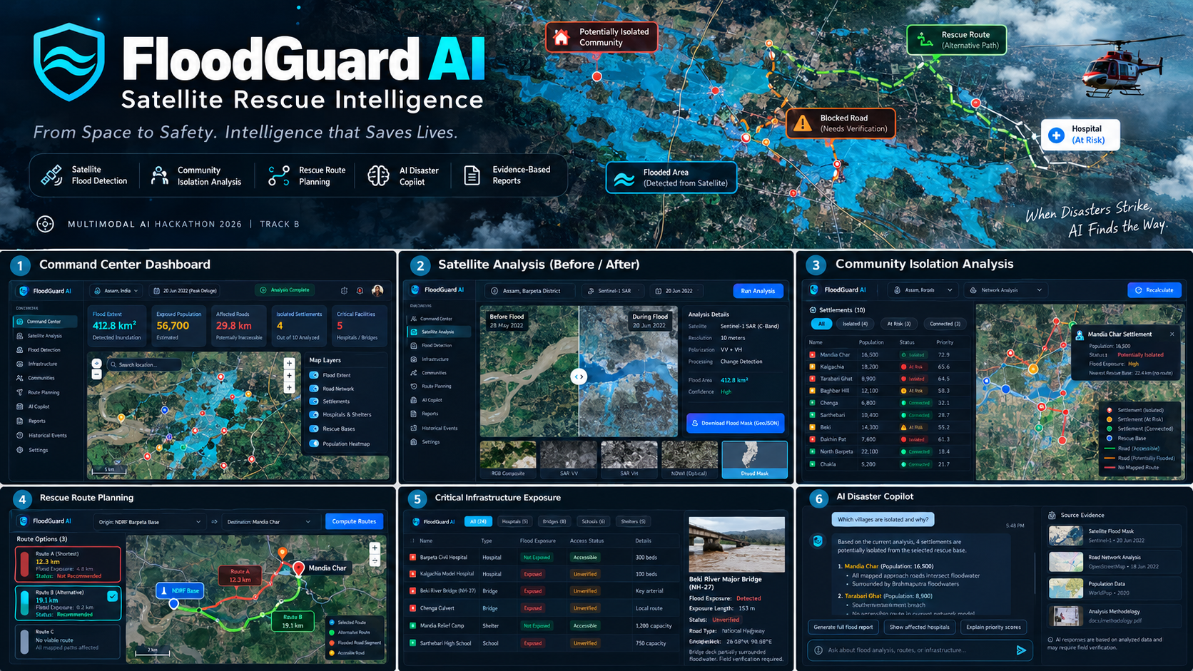
🌊 FloodGuard AI — Satellite Rescue Intelligence
When disasters strike, AI finds the way.
🚨 Inspiration
Every year, devastating floods affect millions of people worldwide, destroying infrastructure, disrupting transportation, and isolating vulnerable communities.
During major floods, emergency responders face a critical challenge: they often cannot determine which areas are submerged, which roads are inaccessible, or which communities urgently need assistance.
Although satellites provide valuable observations of disaster-affected regions, converting raw imagery into actionable rescue intelligence remains challenging.
We asked ourselves:
What if artificial intelligence could transform satellite observations into meaningful information that helps rescue teams make faster, better-informed decisions?
That question inspired FloodGuard AI.
💡 What It Does
FloodGuard AI is a multimodal disaster intelligence platform designed to analyze satellite imagery, identify flood-affected regions, assess infrastructure exposure, and support emergency response planning.
Our vision is to move beyond traditional flood mapping.
Instead of simply showing where floodwater exists, FloodGuard AI aims to answer three critical questions:
- Where has flooding occurred?
- Which communities may have become isolated?
- Where should rescue teams focus their attention first?
🛰️ 1. AI-Powered Flood Detection
FloodGuard AI uses satellite imagery and computer vision techniques to identify flood-affected regions.
By comparing observations from before and during a flood, the system can estimate inundation extent and visualize affected areas on an interactive map.
🗺️ 2. Interactive Disaster Intelligence Dashboard
An interactive geospatial dashboard presents satellite observations, flood extent, affected infrastructure, and settlement locations.
This provides emergency responders with a centralized view of disaster conditions.
🛣️ 3. Infrastructure Exposure Analysis
FloodGuard AI combines flood mapping with geospatial infrastructure data to identify roads, bridges, hospitals, and other critical facilities potentially exposed to flooding.
The system distinguishes observed flood exposure from infrastructure damage that requires field verification.
🏘️ 4. Community Isolation Detection
One of FloodGuard AI's key innovations is its ability to analyze road-network connectivity.
By identifying road segments potentially affected by floodwater, the platform can determine which settlements may have lost access to important transportation routes.
🚑 5. Intelligent Rescue Prioritization
FloodGuard AI is designed to rank affected communities using factors such as:
- Estimated population exposure
- Potential road isolation
- Flood severity
- Critical infrastructure exposure
- Data uncertainty
These factors help generate explainable priority assessments.
🤖 6. FloodGuard AI Copilot
Our AI assistant is designed to help users interact with disaster intelligence through natural language.
Users can ask questions such as:
- Which villages are potentially isolated?
- Which areas require urgent assessment?
- Which roads intersect detected floodwater?
- What infrastructure may be affected?
- Can you generate a disaster assessment report?
The assistant uses available geospatial analysis results to produce understandable explanations.
🛠️ How We Built It
FloodGuard AI combines satellite remote sensing, computer vision, geospatial analytics, graph algorithms, and multimodal artificial intelligence.
Frontend
Next.js, React, Tailwind CSS, and Mapbox or MapLibre for the interactive dashboard.
Backend
Python and FastAPI for data processing and API services.
Satellite Intelligence
Sentinel-1 radar imagery, Sentinel-2 optical imagery, and geospatial processing tools.
Computer Vision
Flood segmentation and satellite change-detection techniques.
Geospatial Analytics
GeoPandas, Rasterio, OpenStreetMap, OSMnx, and NetworkX.
AI Assistant
A multimodal language model for interpreting analysis results and generating natural-language explanations.
Data Storage
PostgreSQL and PostGIS for spatial information.
🌟 What Makes FloodGuard AI Different?
Traditional flood maps primarily communicate the geographical extent of inundation.
FloodGuard AI is designed to connect flood detection with practical emergency-response questions.
Our approach combines:
Satellite Intelligence + Infrastructure Exposure + Community Connectivity + Explainable Rescue Prioritization + Multimodal AI
This integrated approach transforms geospatial observations into information that can support disaster-response planning.
⚡ Challenges We Faced
Flood analysis presents several technical challenges.
Satellite imagery can contain noise, cloud obstruction, and complex surface reflections.
Distinguishing permanent water bodies from newly flooded areas requires careful preprocessing.
Road-network data may also be incomplete, and satellite observations cannot always confirm whether infrastructure is physically damaged or safe to use.
Another challenge is ensuring that AI-generated recommendations are grounded in actual geospatial evidence rather than unsupported assumptions.
These challenges shaped our emphasis on explainable analysis, uncertainty awareness, and human verification.
📚 What We Learned
Building FloodGuard AI demonstrates how multiple technologies can work together to address a meaningful real-world problem.
Key areas of learning include:
- Satellite remote sensing
- Computer vision for environmental monitoring
- Geospatial data processing
- Graph-based connectivity analysis
- Multimodal AI integration
- Explainable decision-support systems
- Human-centered disaster response
🔮 What's Next?
Our long-term vision is to develop FloodGuard AI into a comprehensive disaster intelligence platform.
Potential future capabilities include:
- Near-real-time satellite monitoring
- Automated flood alerts
- Historical flood trend analysis
- Drone imagery integration
- Multilingual emergency-response assistance
- Mobile interfaces for field responders
- Integration with verified emergency-response data
- Advanced flood forecasting
- Human-verified rescue route recommendations
🌍 Our Vision
We believe artificial intelligence should do more than analyze information.
It should help people make meaningful decisions when those decisions matter most.
FloodGuard AI — From satellite imagery to actionable disaster intelligence.
Built With
- computervision
- css
- fastapi
- geminiapi
- geopandas
- geospatialai
- machine-learning
- mapbox
- maplibre
- networkx
- next.js
- opencv
- openstreetmap
- osmnx
- postgis
- postgresql
- python
- pytorch
- rasterio
- react
- satelliteimagery
- sentinel-1
- sentinel-2
- tailwind
- typescript

Log in or sign up for Devpost to join the conversation.