-
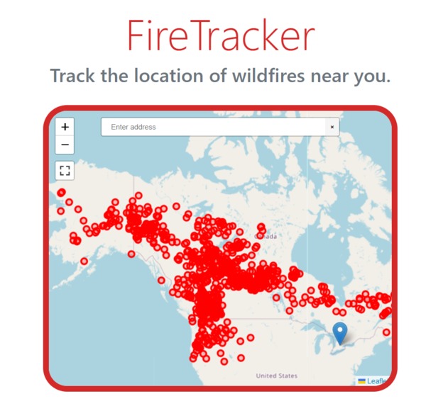
Example of functionality.

Inspiration
As young Canadians, we've always been concerned with the proliferation of wildfires across our country. As climate change continues to ravage the natural world. Wildfires will only continue to grow greater in intensity and frequency.
So we decided to create a tool that empowers all of us to protect ourselves from wildfires.
What it does
FireTracker will get the current user's location and then display their location on a map. Everywhere there's a pin? That's a wildfire.
The map also comes equipped with a search feature and a fullscreen button.
How we built it
We used Leaflet to make our map, Bootstrap for styling, and the plugins leaflet-geoseach and leaflet-fullscreen for the search and fullscreen tools respectively. We got the active fires data, for wildfire locations, from the CWFIS department. We used Javascript to read the data and create the pins.
Challenges we ran into
We had a lot of trouble adding the markers to the map. We also had to learn how to use Javascript and read data.
Accomplishments that we're proud of
This is the first time we've used JavaScript on a website and used real data from a database.
What we learned
- How to use a javascript library.
- How to add a script to a website.
- How to use a frontend library.
- How to use a backend library.
What's next for FireTracker
These are the features we'll be adding next:
- Adding wildfire data from multiple countries.
- Adding live data updates.
- Looking at the nearest wildfire, then telling the user how to protect themselves (evacuation instructions, fireproofing advice, etc).
- Pinging the user through an app, if they're in danger.
- Create a filter for fires across a user's province and all the fires across the country


Log in or sign up for Devpost to join the conversation.