Inspiration
FasalAI began with one uncomfortable observation: farmers make some of the most important decisions in our food system, yet they often have the least access to timely and understandable information. A single unfamiliar spot on a leaf can become a ruined harvest. Choosing the wrong crop for the soil can waste an entire season. Selling produce without knowing current mandi rates can erase months of hard work. The information that could help already exists like weather forecasts, satellite data, disease models, government prices and agricultural research, but it is scattered across complicated websites and technical dashboards.
We kept returning to one question:
What if a farmer could carry an agronomist, weather station, crop doctor and market adviser in one pocket?
That question became FasalAI. We also wanted our project to support a more sustainable future. When farmers cannot identify a disease confidently, they may spray the wrong chemical or use more pesticide than necessary. When crops are poorly matched to local conditions, land, water and money are wasted. Better information does not only improve profits; it can reduce unnecessary chemical use, conserve resources and make farms more resilient to changing weather. Our goal was not to create another dashboard full of numbers. We wanted to turn complex agricultural data into clear, practical decisions.
What it does
FasalAI is not just a single place where farmers can view agricultural information. It is an agricultural intelligence system that collects data from trusted open sources, connects that data to the farmer’s location and runs our own algorithms to produce useful predictions and recommendations. The process begins with location. When a farmer searches for a village, selects a point on the map or uses their current location, FasalAI obtains the coordinates of that farm. Those coordinates become the foundation for the entire analysis. The platform collects relevant information from open services such as weather platforms, satellite datasets, public maps, precipitation services and government agricultural databases. This includes temperature, rainfall, humidity, wind, soil moisture, vegetation health, market prices and other environmental indicators. Raw data alone is not enough. FasalAI cleans, combines and evaluates these values before presenting them to the farmer. Our algorithms use the farm’s location and environmental conditions to generate:
- Soil, water and air health indicators.
- Location-specific crop suitability scores.
- Ranked crop recommendations.
- Estimated yield and input requirements.
- Revenue, cost and profit projections.
- Weather and irrigation insights.
- Disease predictions from crop images.
- Treatment and prevention suggestions.
- Market-price and MSP comparisons. This means that two farmers in different locations can receive different recommendations, even if they open the platform at the same time. Their results depend on the conditions around their own farms.
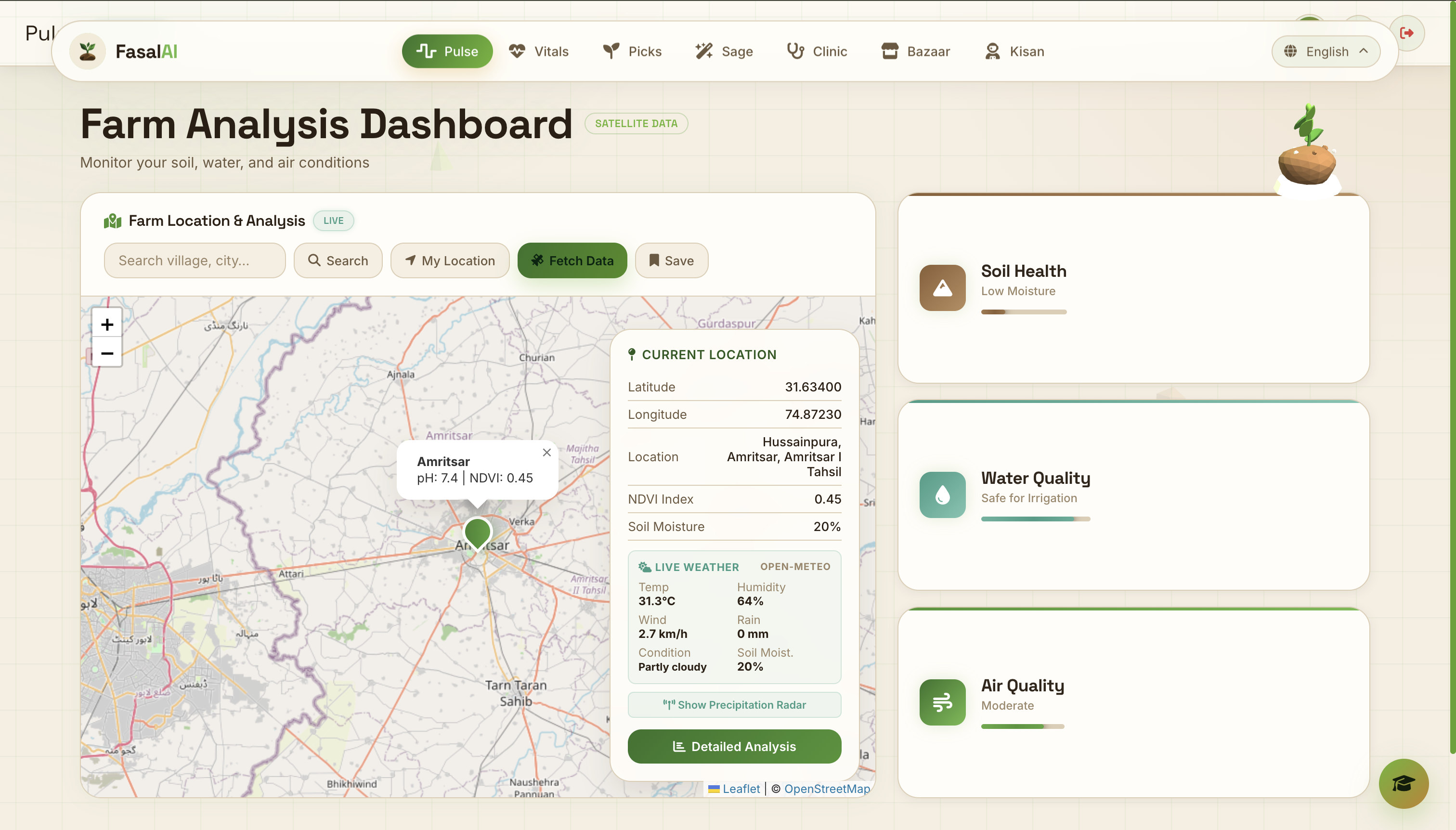
Pulse Pulse creates a live picture of the selected farm. It combines the location with weather, satellite and map data to display factors such as temperature, humidity, rainfall, wind, soil moisture and vegetation health. The platform then converts these readings into simple soil, water and air indicators so that the farmer does not need to understand complicated scientific datasets.
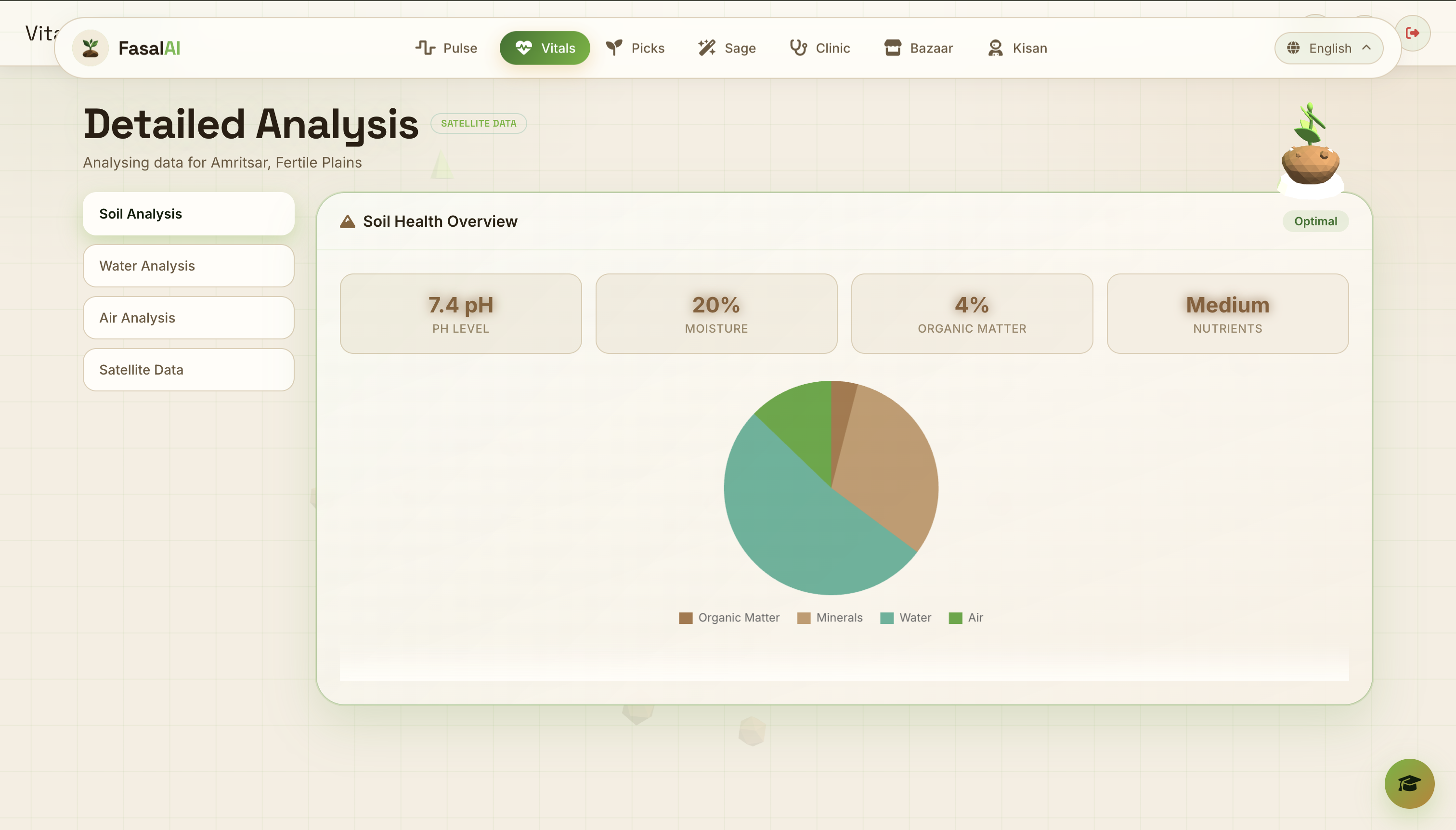
Vitals Vitals provides a more detailed analysis of the farm’s conditions. It converts environmental data into charts and health summaries covering soil, water, air and satellite observations. Instead of only displaying numbers, FasalAI explains whether those measurements are suitable for farming and highlights possible concerns such as low moisture, unsuitable pH or stressful temperatures.
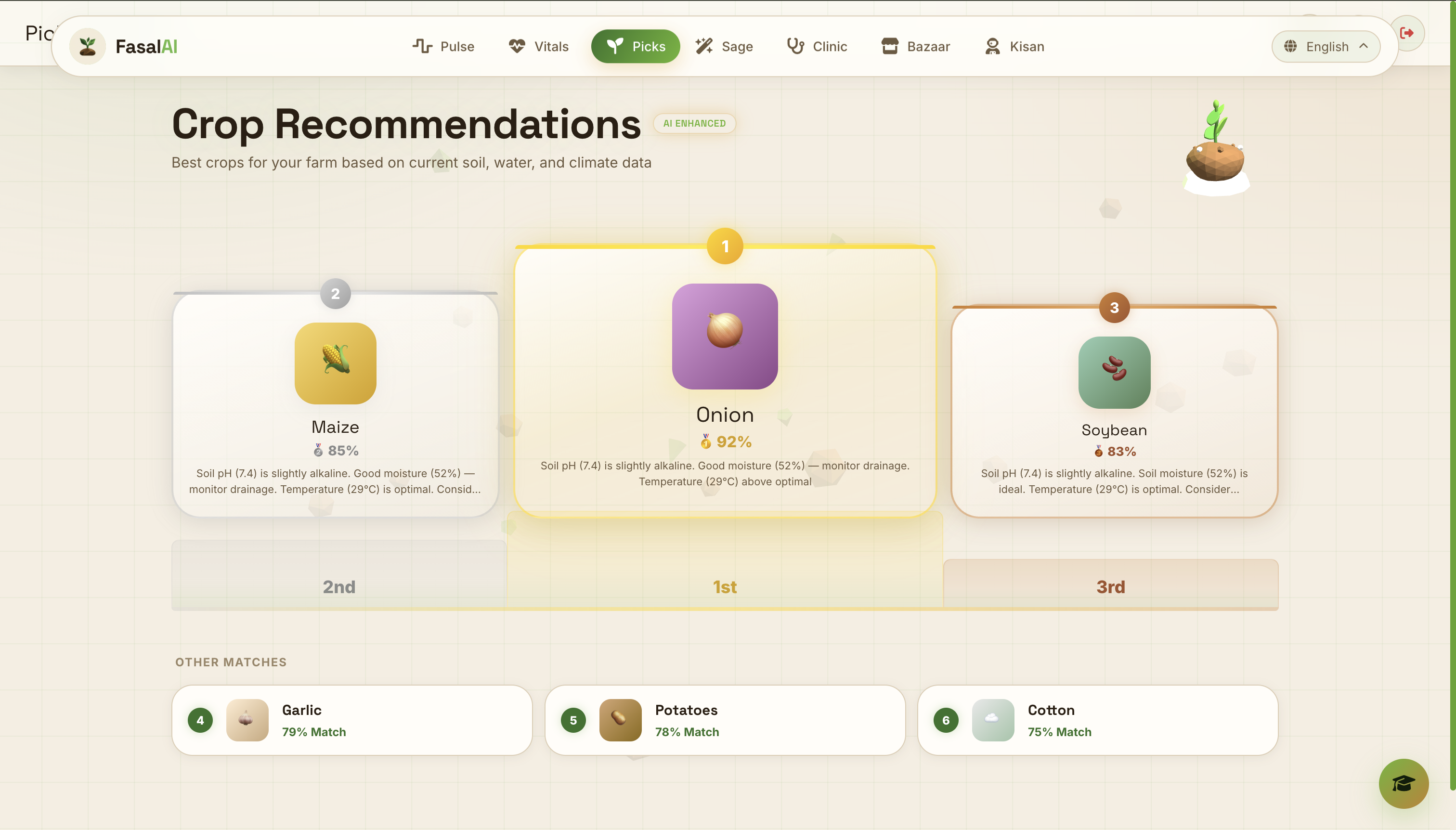
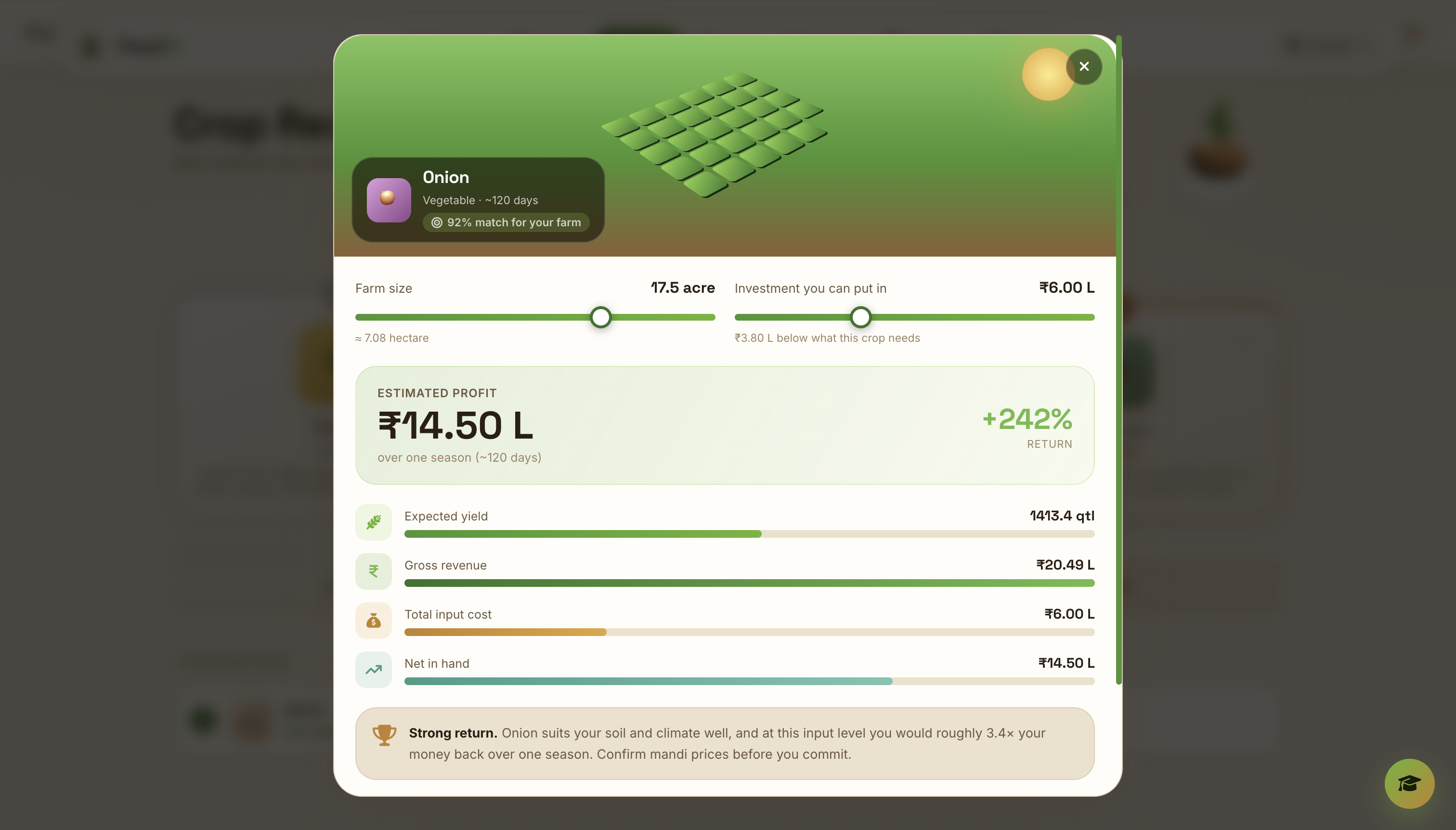
Picks Picks uses our crop-scoring algorithm to compare the farm’s conditions with the preferred growing conditions of different crops. The algorithm evaluates factors such as soil pH, moisture, temperature, climate and local environmental conditions. Each crop receives a suitability score, a ranking and an explanation of the factors that affected its result. Selecting a crop opens the profit simulator. This combines the suitability score with farm size, investment, expected yield, input requirements and available price information. It then estimates the possible production cost, revenue and profit for one growing season. The simulator also models underinvestment and diminishing returns. This prevents the system from assuming that spreading a small budget across more land will always produce a higher profit.
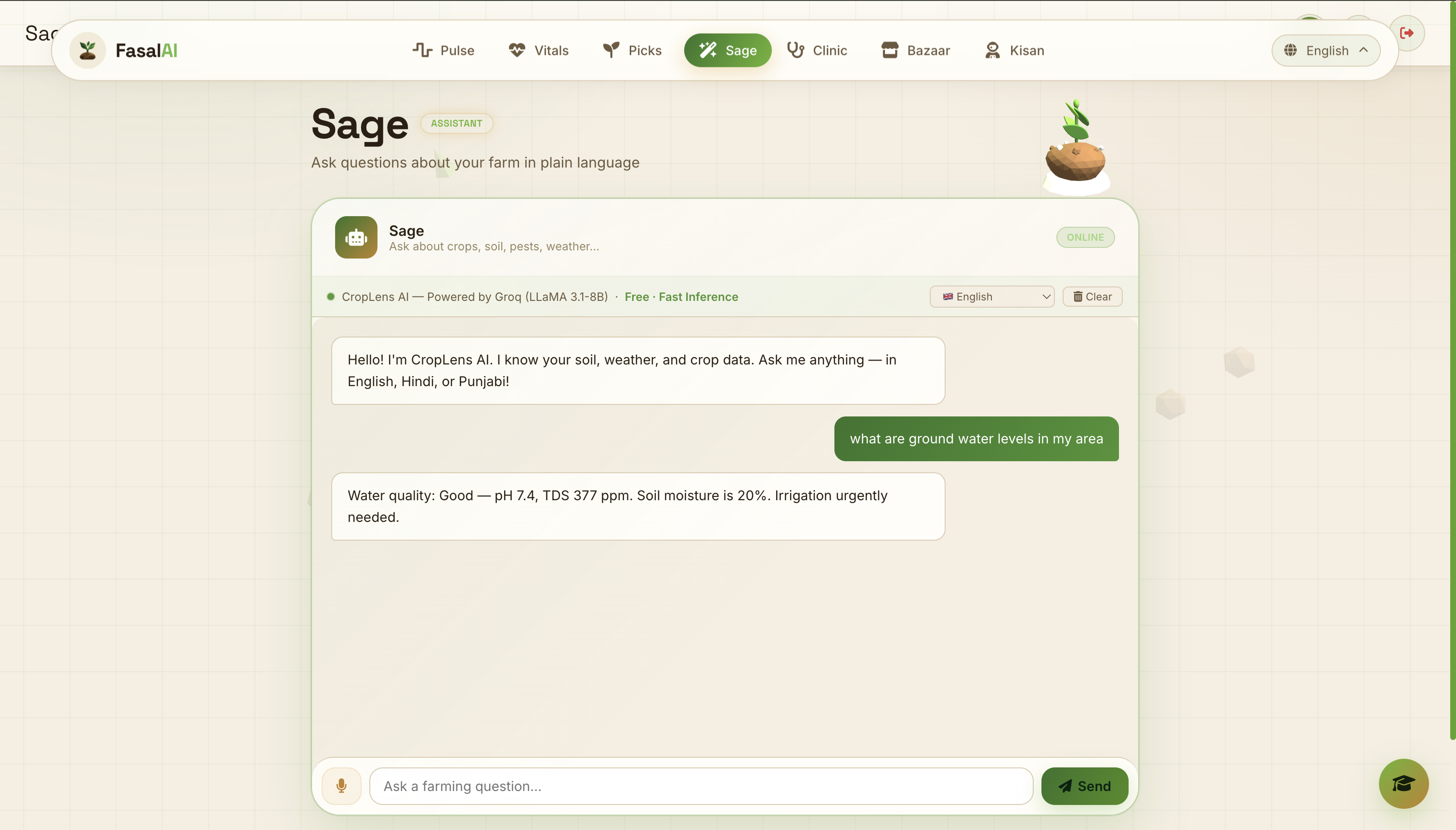
Sage Sage is the conversational intelligence layer of FasalAI. Farmers can ask agricultural questions using text or voice. Sage uses the context already available inside the platform, including the selected location, weather, soil conditions and recommended crops. This allows it to provide answers that are more relevant than a general chatbot response.
Clinic Clinic analyses a photograph of a crop leaf using plant-disease models. It identifies likely diseases, produces a confidence score and provides possible treatments, nutrients, preventive actions and cultural practices. The system is designed to communicate uncertainty. If an image is unclear or does not appear to contain a crop leaf, FasalAI should not invent a confident diagnosis. Serious cases should still be confirmed with a qualified agricultural expert.
Bazaar Bazaar combines government and open agricultural market information with crop-price models. It helps farmers compare wholesale prices, MSP values and market trends. The purpose is not only to help farmers grow the right crop. It is also to help them understand when and where that crop may have greater value. Together, these features create a continuous intelligence pipeline: Location to open data to analysis to prediction to action.
How we built it
WeWe built FasalAI as a responsive web application using HTML, CSS and JavaScript. We chose a lightweight browser-based architecture so that the platform could run on ordinary phones and computers without requiring expensive hardware. At the centre of FasalAI is a location-based data pipeline. When a user selects a farm location, the platform captures its latitude and longitude. It then requests information from multiple open sources. These sources provide weather conditions, geographic information, satellite-informed indicators, precipitation data and agricultural market records. The incoming data may use different formats, units and update schedules. We therefore process and normalize it before it reaches the prediction layer. Missing or unavailable values are handled through fallback logic so that one failed service does not make the entire platform unusable. After normalization, our algorithms evaluate the data in several stages. Environmental analysis Weather, soil, water, air and satellite values are converted into understandable health indicators. The system checks these measurements against useful agricultural ranges and identifies conditions that may affect crop growth. Crop suitability prediction Each crop has preferred environmental conditions. Our crop-scoring algorithm compares those requirements with the conditions at the selected location. The score is calculated using several factors rather than a single measurement. Soil pH, moisture, temperature and climate compatibility all influence the final result. The platform then ranks the crops and explains why each one received its score. Yield and profit prediction FasalAI combines crop suitability with farm size, investment level, expected yield, input costs and available market-price information. The algorithm adjusts its estimate when the available investment is below the crop’s typical requirement. It also accounts for diminishing returns so that the prediction remains realistic as investment increases. These calculations produce an estimated yield, total input cost, gross revenue, net profit and expected return. The figures are presented as planning estimates rather than guaranteed outcomes because real harvests are affected by weather, labour, crop variety, pest pressure and changing market prices. Disease prediction The Clinic uses image-analysis services and plant-disease models from platforms such as Roboflow and Hugging Face. A submitted leaf image is analysed and matched against known disease classes. The system then connects the prediction to treatment, nutrient, prevention and crop-care guidance. Confidence information is included so that users can judge how strongly they should rely on the result. Market intelligence FasalAI is designed to use open government datasets such as AGMARKNET and data.gov.in for agricultural prices and MSP information. The platform combines price records with crop and location context so that market data becomes part of the farmer’s decision process rather than an isolated table of numbers. For the interface, we used Leaflet.js and OpenStreetMap for interactive maps, Chart.js for agricultural visualizations and Three.js for visual depth. Open-Meteo supplies live weather information, while RainViewer supports precipitation-radar data. Sage is powered by Groq (Model- GPTOS, earlier Llama) for fast conversational responses. Firebase Authentication and Firebase Realtime Database support user accounts and cloud data, while browser storage provides a fallback for preferences, history and selected farm information. The most important technical idea behind FasalAI is that no dataset works alone. The value comes from connecting multiple open sources, processing them through our algorithms and transforming the result into a prediction that is specific to the farmer’s location. FasalAI does not simply show farmers more data. It turns available data into decisions they can understand and act upon.
Challenges we ran into
Our biggest challenge was not adding features, it was making several complicated systems feel like one simple product. Agricultural data comes from different sources, in different formats, with different update schedules. Turning coordinates, weather conditions, soil estimates, disease predictions and market records into consistent recommendations required careful normalization and fallback logic. Another challenge was presenting uncertainty honestly. A weather API can fail. A market price may be unavailable. A plant image may be blurry. An AI model may return a low-confidence prediction. We learned that a trustworthy agricultural platform must clearly distinguish between live information, estimates and recommendations. The profit simulator was particularly challenging. A simplistic calculator can produce attractive but misleading results. We instead modelled how underinvestment affects establishment and yield, while also accounting for crop compatibility and diminishing returns. Designing for accessibility created another layer of difficulty. Agricultural terms do not always translate naturally, and a technically correct translation may still sound unfamiliar to a farmer. We therefore gave special attention to Hindi, Punjabi and English while building a system that can support many more languages. Finally, we had to maintain performance while combining maps, charts, AI services and visual effects inside a browser-based application. This pushed us to build lightweight components and graceful fallbacks rather than depending on one perfect connection.
Accomplishments that we're proud of
We are proud that FasalAI tells one coherent story. It begins with a farm on a map, not with a technical form. It turns environmental readings into understandable health indicators. It recommends crops for those conditions, models whether growing them makes financial sense, helps identify diseases and finally provides information for selling the harvest. We are especially proud of:
- Building a working, end-to-end agricultural platform instead of a single-purpose prototype.
- Combining environmental sustainability with the farmer’s economic reality.
- Making advanced data understandable through visual explanations and actionable language.
- Supporting voice interaction and multilingual use.
- Designing a disease workflow that communicates confidence instead of presenting every prediction as fact.
- Creating fallback behaviour so that one unavailable service does not make the entire platform useless.
- Keeping the experience accessible from a web browser without requiring expensive hardware. The result is captured by our tagline:
What we learned
The most important lesson was that responsible AI is not simply about producing an answer. It is about helping someone understand why that answer was produced, how certain it is and what they should do next. We also learned that sustainability and profitability do not have to compete. A farmer who chooses crops suited to local conditions can use water and inputs more efficiently. Earlier disease identification can reduce unnecessary spraying. Better market awareness can improve income without demanding greater production from the land. Technically, we learned how to coordinate mapping, weather, satellite, machine-learning, language and market-data services inside one responsive experience. More importantly, we learned to judge every technical decision from the user’s perspective: Does this help someone make a better decision today?
What's next for Fasal AI
Our next goal is to take FasalAI from an India-focused platform to a truly global agricultural companion. To make the platform useful across different countries, we plan to introduce flexible measurement systems. Farmers will be able to choose between units such as acres and hectares, Celsius and Fahrenheit, kilograms and pounds, millimetres and inches, and local currencies. Recommendations will also adapt to regional growing seasons, climates, crop varieties and farming practices. We want to build a worldwide agricultural market-data network by combining official crop-price information published by governments across the globe. Instead of depending on one country’s mandi system, FasalAI could compare government-reported prices, regional markets, support prices and historical trends. The information would be converted into the farmer’s preferred currency and units. This would help farmers understand what to grow, where to sell and when their produce may have the greatest value. Connectivity should never decide who can access agricultural intelligence. We therefore plan to release a fully offline app with downloadable regional data packs and on-device AI models. Core features such as crop-disease detection, saved farm information, treatment guidance and basic recommendations would continue working without internet access. When connectivity returns, the app could automatically synchronize weather, satellite and market updates. Another major feature on our roadmap is a video-based soil analyser. A farmer could slowly move their phone camera across different parts of a field while FasalAI studies visible properties such as soil colour, texture, moisture patterns, surface cracking, residue and drainage conditions. The app would combine this visual evidence with location, weather and satellite data to produce an initial soil-health assessment and recommend appropriate tests, crops and treatments. It would serve as a screening tool rather than a replacement for laboratory testing, with its confidence and limitations clearly communicated. We also plan to add:
- Regional yield and input-cost datasets for more accurate profit forecasts.
- A privacy-conscious farmer-to-farmer disease outbreak map.
- SMS and voice-based access for farmers without smartphones.
- More crops, diseases and locally reviewed languages.
- Transport costs and nearby-market comparisons.
- Crop-cycle reminders for irrigation, nutrition and preventive care.
- Validation partnerships with agricultural universities, research institutions, KVKs and field experts. FasalAI started by bringing scattered agricultural information into one accessible platform. Our larger vision is to build a global, multilingual and offline-capable agricultural intelligence network that understands the farmer’s land, language, local market and available technology, wherever they are in the world.
Built With
- agmarknet
- chart.js
- css3
- data.gov.in
- firebase
- firebase-database
- font-awesome
- google-translate
- google-web-authentication
- groq
- html5
- hugging-face
- javascript
- leaflet.js
- mobilenetv2
- nasa-power-api
- open-meteo-forecast
- openstreetmap
- railway
- rain-viewer
- roboflow
- three.js
- web-speech-api


Log in or sign up for Devpost to join the conversation.