-
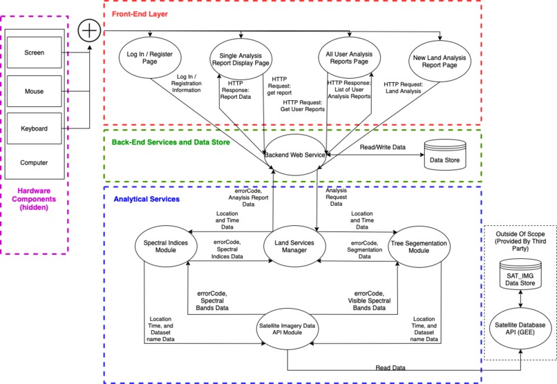
Component Diagram
Inspiration
As children some of us have been to the great barrier reef and it was an amazing experience. Now with the problems such as climate change and pollution that have effected these natural wonders, we were inspired to help people maintain land better in general. There has not been much advancements in the ways of keep an eye on our land considering the advancements in technology so we have come up with ideas of how we can use satellite images and to run models on these images in order to get information that you would not be able to otherwise know in order to take the best care possible of the land.
What it does
Our application takes in coordinates of a location through an interactive Google Maps environment and will run models on that area of land in order to analyze it, reporting various information such as water index, vegetation index, normalized vegetation index, burn area index, mosture index, mineral and clay indices, and land coverage segmentation.
How we built it
We built this with a reactJS frontend and an express server backend. Our backend talks to our python analytical model that handle the indices and land coverage prediction. Please see the component diagram above.
Challenges we ran into
Dataset usability was one big issue. We found that although there was many good datasets out there, not all of them were usable, rendering them useless. There was challenges with some of the libraries that we were working with. Not everyone was able to download the libraries and work with them due to difference in computer architectures and different operating systems. We were able to work around this by using the Git versioning system.
Accomplishments that we're proud of
Able to get good images of indices that do vegetation, moisture levels, and high resolution RGB maps for land cover segmentation
What we learned
There are a lot of cool datasets that we can work with in order to accomplish these tasks. These objectives can be accomplish through many different means.
What's next for EnviroHack
We plan on expanding on the idea of this project by adding drones that will have the capability of streaming the images of the land rather than using satellites. This gives the user more real-time updates of the area of interest. Furthermore, we want to be able to use the drone to accomplish some tasks such as planting trees and cleaning trash in order to save take care of the land autonomously.

Log in or sign up for Devpost to join the conversation.