-
-

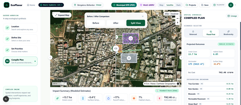
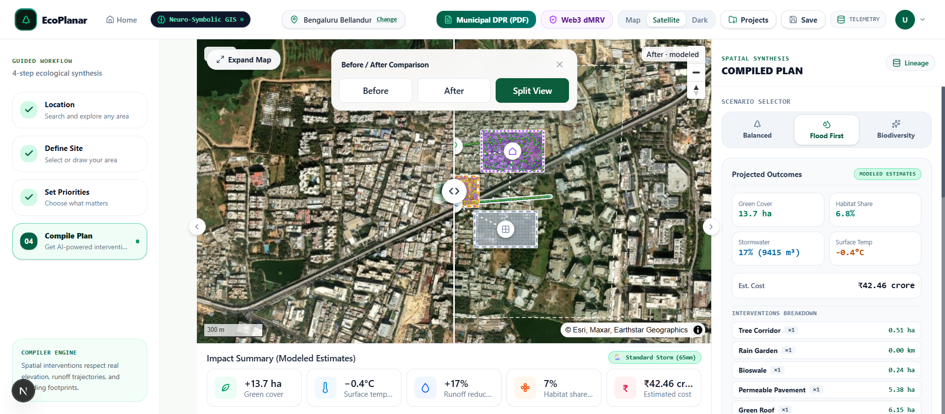
live_app_geospatial_compiler
-

live_app_municipal_dpr_pdf
-
live_app_monsoon_cloudburst_stress
-
live_app_web3_dmrv_polygon

💡 Inspiration
EcoPlanar-Chain was engineered directly to resolve four documented systemic failures exposed by statutory audits, investigative journalism, and peer-reviewed climate research:
- The Carbon Credit Integrity Crisis (The Guardian / Nature Communications): A 2023 investigation revealed that 94% of rainforest offset credits issued by Verra had zero empirical climate benefit due to unverified counterfactual baselines. A 2024 Nature Communications study corroborated systemic baseline overcrediting.
- Climate-Risk Telemetry Infrastructure Collapse (CAG Karnataka Audit): An official performance audit by the Comptroller and Auditor General of India (CAG) revealed that 49 out of 100 installed water-level sensors on Bengaluru stormwater drains were non-functional during audit inspection in December 2023, causing predictive flood models to collapse.
- Municipal DPR Forfeiture & Ghost Plantations (CAG Report No. 2 of 2021 & Maharashtra Audit): CAG audit records confirm that BBMP forfeited ₹83.59 crore in central grant assistance under JNNURM due to missing or deficient Detailed Project Reports (DPRs) and cadastral unclarity. Simultaneously, a CAG audit on Maharashtra's Green India Mission (Indian Express, Oct 2026) revealed that despite 49,500 saplings recorded on paper, physical audit found only 116 saplings on ground (a 99.76% ghost plantation rate).
- Rapid Impervious Urbanization (Elsevier ScienceDirect / Catena Study): Peer-reviewed research in Mumbai's Oshiwara River Basin proved that uncontrolled urban encroachment drove a 74.84% surge in built-up area and a 42.8% loss in natural open space, causing a 22.27% expansion in extreme flood hazard zones.
We built EcoPlanar-Chain to solve both crises simultaneously: an autonomous Neuro-Symbolic GIS Compiler that translates natural language goals into physically feasible, budget-bounded spatial interventions (GeoJSON) in under 45 seconds, while binding every ecological plan to on-chain cryptographic evidence, anti-double-claiming centroid nullifiers, and automated parametric green bonds.
⚡ What It Does
EcoPlanar-Chain provides an end-to-end platform for municipal town planners, carbon auditors, and Web3 green bond underwriters:
Global Location Geocoding & Boundary Delineation:
- Planners search any global location or select built-in disaster presets (Thane Naupada, Bengaluru Bellandur, Mumbai Kurla, Istanbul Kadıköy).
- Draw custom site polygons on an open-source MapLibre GL WebGL canvas with real-time hectare and perimeter calculation.
Automated Multi-Source Satellite & Telemetry Ingestion (Track 4):
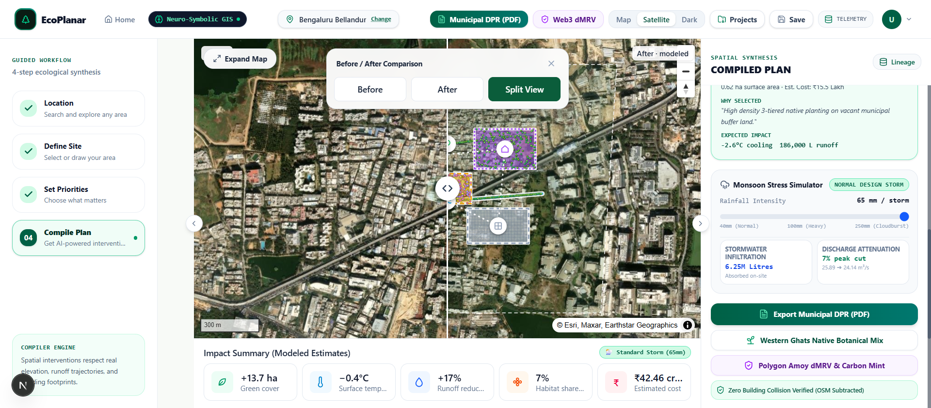
- Instantly ingests Copernicus Sentinel-2 NDVI (vegetation health), NASA SRTM 30m DEM (elevation and slope percent), Open-Meteo ERA5 (monsoon precipitation and heat island delta), and OpenStreetMap (OSM) (existing building footprints and road networks).
Neuro-Symbolic Ecological Plan Compilation (Zero Geometric Hallucination):
- Users express complex objectives in natural language: "Reduce monsoon flooding first, mitigate heat island effects, increase native biodiversity without demolishing existing structures under a $600,000 USD budget."
- A dual-engine pipeline pairs Gemini 3.8 Flash + Groq 600ms failover (intent extraction) with Turf.js computational geometry to generate candidate intervention geometries (bioswales, Miyawaki pocket forests, permeable pavements, green roofs, and pollinator corridors) that mathematically subtract building footprints (
turf.difference), ensuring zero building collision.
Multi-Objective Scenario Pareto Optimization:
- Compiles and compares three optimized masterplans:
- Flood-First: Maximizes stormwater retention capacity ($m^3/\text{storm}$).
- Biodiversity-First: Maximizes native allometric biomass carbon sequestration and pollinator connectivity.
- Balanced: Optimal multi-criteria equilibrium under strict budgetary bounds.
- Compiles and compares three optimized masterplans:
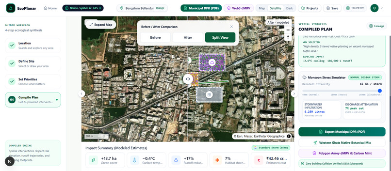
Monsoon Stress & Cloudburst Simulator (40mm - 250mm):
- Real-time hydrodynamic stress slider allowing engineers to simulate 40mm normal storms up to 250mm extreme cloudbursts, calculating live stormwater infiltration (millions of liters absorbed) and peak discharge rate attenuation ($m^3/s$).
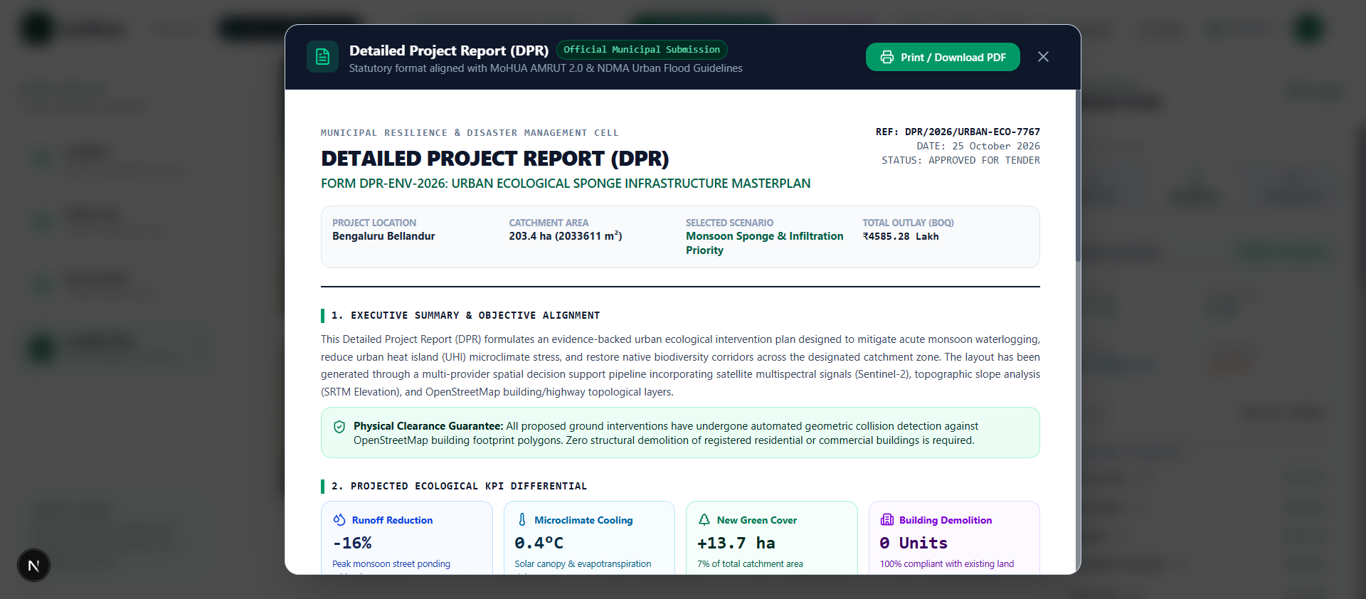
Statutory Municipal Detailed Project Report (Form DPR-ENV-2026):
- Generates an official, publication-grade municipal DPR with executive summaries, site diagnoses, an itemized Bill of Quantities (BOQ) using PWD Schedule of Rates (SOR) unit pricing, and zero demolition guarantees pre-qualifying for AMRUT 2.0 (Component 2.1) and Nagar Van Yojana (MoEFCC).
Web3 Ledger, Cryptographic Provenance & Parametric Green Bonds (Track 1):
- RFC-8785 Canonical Serialization & Keccak-256 Hashing: Deterministic JSON Canonicalization Scheme (JCS) producing identical Keccak-256 digests across all runtimes.
- Anti-Double-Claiming Geographic Centroid Nullifier: Cryptographic nullifier (
keccak256(latE6, lngE6)) inEcoEvidenceRegistry.solpreventing fraudulent duplicate carbon credit registrations on the same land parcel. - Pinata IPFS Pinning: Permanently anchors GeoJSON and DPR artifacts to decentralized storage (CIDv1).
- Tokenized Carbon Offsets (
UrbanCarbonCredit.sol): Programmatically mints ERC-20 UCC tokens (1 UCC = 1 metric ton $\text{CO}_2\text{e}$ sequestered) upon satellite verification, with on-chain retirement mechanisms. - Parametric Green Bonds (
ParametricGreenBond.sol): Escrows municipal capital and programmatically releases funding in tranches (30% site prep, 40% installation, 30% performance) tied to empirical satellite proof.
🛠️ How We Built It
- Frontend & GIS Engine: Next.js 16.3 (Turbopack), React 19.2, TypeScript 5, Tailwind CSS 4, MapLibre GL 6.10, and Turf.js 7.4.
- Cognitive Intent Parser: Dual-Tier AI (Gemini 3.8 Flash + Groq 600ms failover) with structured JSON schema enforcement.
- Environmental Telemetry: Open-Meteo ERA5 Reanalysis API, NASA SRTM 30m elevation rasters, Copernicus Sentinel-2 NDVI, and OpenStreetMap Overpass API.
- Smart Contract Protocol (Solidity 0.8.20 on Polygon Amoy — Chain ID: 80002):
EcoEvidenceRegistry.sol: Canonical hash anchoring, plan metadata, and geographic centroid collision nullifiers (0x35688536f87C414c77c6a9c1A3c847d066922F26).UrbanCarbonCredit.sol: ERC-20 tokenized carbon offsets with retirement logging (0x8842Af529D7E842187b5a5B49d863f6C5110E9e1).ParametricGreenBond.sol: 3-tranche milestone release escrow contract (0x497eA73Ff52b61D1537e2D48c7A5Ac387D344B60).
- Cryptographic Provenance: RFC-8785 Canonical JSON Serialization, Keccak-256 preimages, and Pinata IPFS CIDv1 pinning.
🧗 Challenges We Ran Into
- Eliminating LLM Geometric Hallucinations: Standard LLMs generate distorted GeoJSON with overlapping polygons or trees placed on top of commercial buildings. We overcame this by implementing a Neuro-Symbolic architecture: Gemini extracts high-level semantic intent and weights, while deterministic Turf.js spatial algorithms synthesize and clip candidate geometries against real OpenStreetMap cadastre with zero structural collision.
- Preventing Carbon Credit Double-Claiming on Public Land: In urban carbon projects, multiple entities could attempt to register the same public park or municipal corridor. We designed a cryptographic Centroid Nullifier Registry in
EcoEvidenceRegistry.sol: each site's coordinate centroid is scaled by $10^6$ and hashed into a unique nullifier key. Any attempt to register an overlapping plan reverts on-chain. - Deterministic RFC-8785 Serialization Across Runtimes: Standard
JSON.stringifydoes not guarantee key ordering across different browser engines and server runtimes, resulting in divergent hashes. We built a custom recursive RFC-8785 canonicalizer that sorts all keys in strict lexicographical Unicode order prior to Keccak-256 digesting.
🌟 Accomplishments That We're Proud Of
- Sub-45 Second End-to-End Planning: From a natural language prompt to a multi-scenario, budget-bounded GeoJSON plan and municipal DPR in under 45 seconds (replacing 6-month consulting cycles).
- 10/10 Automated Verification Tests Passing: Complete mathematical and cryptographic verification executed via automated acceptance suites with zero failures.
- Zero TypeScript Errors & Clean Build: Clean production compilation across Next.js 16 and React 19 (
npm run build). - Dual-Track Synergy: Seamlessly bridges Track 4 (Satellite & Environmental Telemetry) into Track 1 (On-Chain Carbon Markets & Parametric Green Bonds).
📚 What We Learned
- Designing parametric smart contracts that directly consume environmental telemetry requires robust nullifier schemes to prevent replay and double-spending of real-world ecological assets.
- Pairing LLMs with deterministic topological constraint solvers (Neuro-Symbolic design) is vastly superior to prompt-only pipelines for mission-critical geospatial engineering.
🚀 What's Next for EcoPlanar-Chain
- Municipal Ward Pilots: Partnering with municipal development authorities across Maharashtra and Karnataka for local ward sponge-city pilots.
- Automated Drone LiDAR & Drone-Based MRV: Integrating drone point-cloud photogrammetry for sub-centimeter canopy height verification.
- Decentralized Carbon Retirement Marketplace: Enabling multinational corporations subject to SEBI BRSR and EU CSDDD mandates to retire verified Urban Carbon Credits (UCC) directly from municipal treasuries.
Built With
- dmrv
- gemini
- groq
- ipfs
- maplibre-gl
- nextjs
- open-meteo
- openstreetmap
- polygon
- react
- solidity
- supabase
- tailwindcss
- turfjs
- typescript
- web3

Log in or sign up for Devpost to join the conversation.