-
-
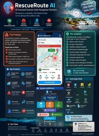
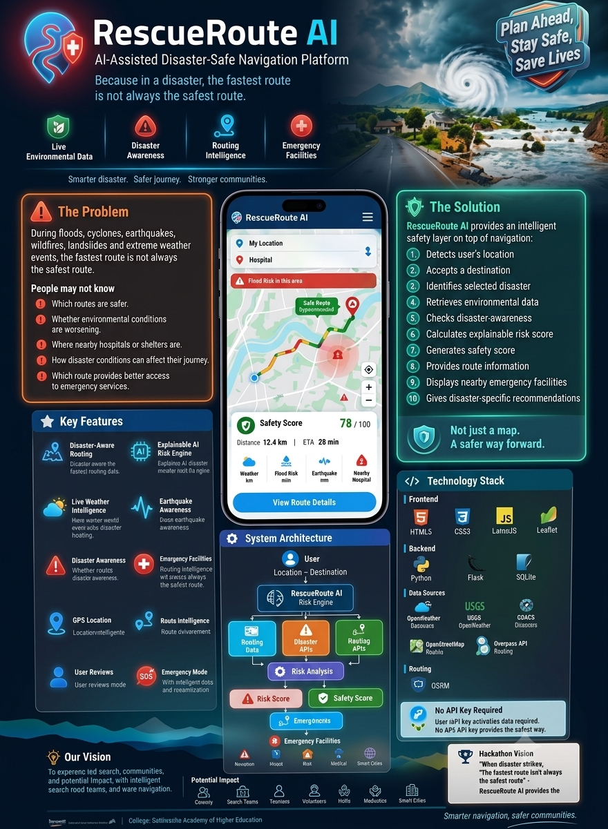
AI-powered disaster-safe navigation for smarter emergency decisions.
Inspiration
What it does
How we built it
Challenges we ran into
Accomplishments that we're proud of
What we learned
What's next for RescueRoute AI
RescueRoute AI
Inspiration
During a disaster, people don't simply need a route — they need the right route.
A road that is normally the fastest may become dangerous during a flood. A route through a low-lying area may become inaccessible. During a wildfire, cyclone, earthquake, or landslide, conditions can change faster than people can react.
We realized that conventional navigation mainly answers one question:
“How can I reach my destination fastest?”
But during an emergency, the more important question is:
“How can I reach my destination as safely as possible?”
That question inspired us to build RescueRoute AI, an AI-assisted disaster-safe navigation platform that adds a safety intelligence layer to everyday navigation.
Our vision is simple:
The fastest route is not always the safest route.
What it does
RescueRoute AI combines navigation with disaster and environmental intelligence to help users make safer travel decisions.
A user can provide their current location, destination, and disaster condition. The platform then combines available environmental and geospatial signals to generate an explainable risk assessment and safety score.
The platform provides:
- 📍 Current-location detection
- 🗺️ Interactive map-based navigation
- 🧭 Route distance and estimated travel time
- 🌦️ Live weather information
- 🌍 Recent earthquake awareness
- 🚨 Disaster-event awareness
- 🤖 Explainable AI-assisted risk scoring
- 🛡️ Safety scoring
- 🏥 Nearby hospitals and clinics
- 🚔 Police facilities
- 🚒 Fire stations
- 🏠 Shelters
- 🚑 Ambulance facilities
- 👤 User accounts and saved analyses
- 🚨 Emergency Mode
- 💡 Disaster-specific safety recommendations
Instead of simply returning a route, RescueRoute AI attempts to answer:
“What risks should I be aware of before taking this journey?”
How we built it
We designed RescueRoute AI as a modular system where different real-world data sources contribute to one safety assessment.
1. User Layer
The user provides:
Location → Destination → Disaster Condition
The browser can obtain the user's location through GPS.
2. Environmental Intelligence
The system retrieves current environmental information such as:
- Temperature
- Rainfall
- Wind speed
- Wind gusts
- Humidity
- Visibility
This information is used as contextual input for the risk engine.
3. Disaster Intelligence
The platform incorporates disaster-awareness information such as recent earthquake activity and global disaster-event information.
4. Routing Intelligence
The routing layer calculates:
- Route distance
- Estimated travel time
- Route geometry
The route is visualized directly on an interactive map.
5. Emergency Infrastructure
RescueRoute AI searches geospatial data for nearby emergency facilities including hospitals, police stations, fire stations, shelters, and ambulance facilities.
6. Explainable AI-Assisted Risk Engine
Instead of producing an unexplained number, our risk engine evaluates multiple factors and identifies why the risk score changes.
For example:
Heavy rainfall + flood condition + long route
can increase the assessed risk.
The result is presented as:
Risk Score + Safety Score + Risk Factors + Recommendation
This makes the system easier for users and judges to understand.
7. Application Layer
The complete prototype was implemented using:
- Python
- Flask
- SQLite
- HTML
- CSS
- JavaScript
- Leaflet
The architecture was intentionally kept lightweight so that the prototype can be demonstrated quickly without requiring a paid API key or downloading a large AI model.
Challenges we ran into
Building a disaster-aware navigation system presented several challenges.
Challenge 1 — Real-world conditions are dynamic
Disaster conditions can change rapidly. A route that looks safe at one moment may not remain safe.
We therefore designed the system around live and frequently updated information rather than relying only on static information.
Challenge 2 — Combining different data sources
Weather, earthquakes, disaster events, maps, routing, and emergency facilities come from different sources and have different formats.
We had to create a common processing layer that could transform these signals into information understandable by the risk engine.
Challenge 3 — Making AI explainable
A safety score without an explanation would not be useful.
Instead of simply showing:
Risk = 72
we show contributing factors such as:
- Heavy precipitation detected
- Strong wind conditions
- Nearby seismic activity
- Longer travel distance
This makes the system more transparent.
Challenge 4 — Building a meaningful prototype quickly
As a hackathon project, we had limited development time.
We focused on building a complete end-to-end experience rather than spending all our time on one isolated feature.
The result is a working prototype covering:
Location → Data → Risk Analysis → Route → Emergency Facilities
Accomplishments that we're proud of
We are proud that RescueRoute AI evolved from a simple disaster-management idea into a complete decision-support prototype.
🚀 From navigation to safety intelligence
We didn't want to build another map application.
We built a concept where navigation becomes context-aware.
🤖 Explainable risk assessment
The system doesn't just provide a score. It provides understandable reasons behind the assessment.
🌍 Multiple real-world data sources
We successfully connected environmental, disaster, geospatial, and routing information into one platform.
🏥 Emergency infrastructure awareness
The system connects navigation with nearby emergency resources, making the concept more useful during real emergencies.
⚡ Lightweight architecture
The prototype can operate without a proprietary AI API key or a large downloaded model, making it easier to demonstrate and extend.
🌎 Designed for global scalability
Although the prototype can be demonstrated in a specific location, its architecture is not limited to one city.
The same concept can be adapted to different regions by integrating local disaster, weather, traffic, and emergency-service data.
What we learned
The biggest lesson was that AI in the real world is not only about building a bigger model.
It is also about:
choosing the right data → combining it intelligently → explaining the result → turning it into an actionable decision.
We learned how different geospatial and environmental data sources can work together to create a more meaningful user experience.
We also learned that in emergency applications, trust and explainability are just as important as intelligence.
A user should understand why a system considers something risky before making an important decision.
Most importantly, we learned to design technology around a human question rather than around a technology:
“How can we help someone make a safer decision when conditions are changing?”
What's next for RescueRoute AI?
The current prototype is only the beginning.
Our long-term goal is to evolve RescueRoute AI from an AI-assisted prototype into a real-time global disaster mobility intelligence platform.
1. Predictive risk forecasting
Instead of only evaluating current conditions, future versions could predict how route risk may change over the next 30, 60, or 120 minutes.
2. Real-time traffic integration
Traffic congestion, road closures, accidents, and evacuation routes could be incorporated into route safety calculations.
3. Flood and road-condition intelligence
Flood-depth information, water-level sensors, road closures, and municipal data could help identify roads that may become inaccessible.
4. Satellite and computer vision intelligence
Satellite imagery and computer vision could potentially detect:
- Flooded roads
- Fire zones
- Damaged infrastructure
- Landslide areas
- Blocked routes
This could significantly improve disaster awareness.
5. IoT integration
Future versions could receive information from:
- Water-level sensors
- Weather stations
- Emergency beacons
- Smart-city infrastructure
- Disaster-response sensors
6. Official emergency integration
The platform could integrate verified government emergency alerts and evacuation instructions so users receive trusted information alongside route recommendations.
7. Offline emergency navigation
During disasters, internet connectivity may fail.
A future version could provide offline maps, cached emergency facilities, and downloadable evacuation routes.
8. Multi-route safety comparison
Instead of showing one route, RescueRoute AI could compare:
Fastest Route vs Safest Route vs Emergency-Access Route
and allow the user to understand the trade-offs.
9. AI-powered emergency assistant
A future conversational assistant could answer questions such as:
“Which nearby shelter is accessible?”
“Why is this route considered risky?”
“What should I avoid on this journey?”
10. Global disaster mobility network
Our ultimate vision is to create a platform that can work across cities and countries by connecting local disaster intelligence, environmental data, transportation systems, emergency infrastructure, and AI.
Our Vision
RescueRoute AI is built around one belief:
When a disaster changes the world around us, navigation should change with it.
We want to move from route navigation to risk-aware mobility — helping individuals, communities, emergency teams, NGOs, and authorities make better decisions when every minute matters.
RescueRoute AI — Smarter Navigation. Safer Decisions. Stronger Communities.
Built With
- ai
- climate
- disaster
- emergency
- explainable
- flask
- gdacs
- geospatial
- intelligence
- javascript
- leaflet.js
- management
- open-meteo
- openstreetmap
- osrm
- python
- response
- usgs


Log in or sign up for Devpost to join the conversation.