-
-
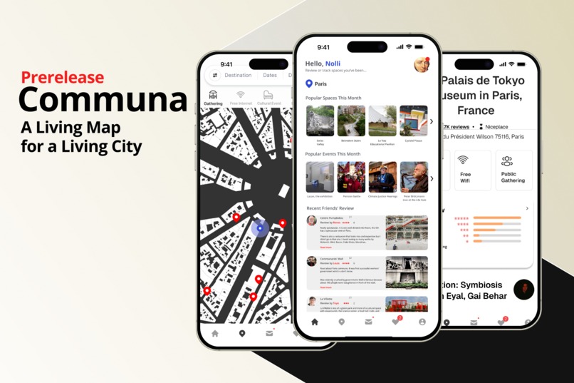
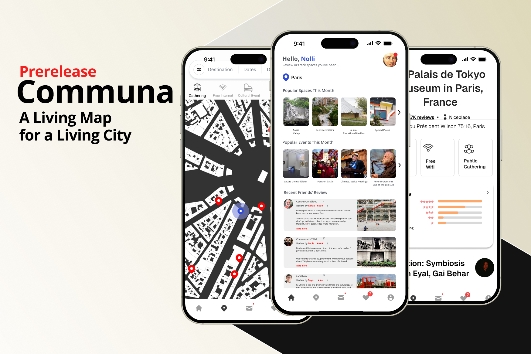
Discover, Explore, and Connect – A Living Map for a Living City
Communa: Staying Human in the Age of AI
Inspiration
Traditional navigation apps like Google Maps and Apple Maps prioritize directions and static locations, often overlooking the social and experiential aspects of urban spaces. Inspired by Giambattista Nolli’s 1748 map of Rome, which uniquely represented public accessibility, we set out to design a mapping platform that fosters human interaction, real-time event discovery, and social engagement.
“A city is not just its streets—it’s the people, interactions, and experiences that bring it to life.”
In an era where digital tools often isolate individuals, Communa aims to bridge the gap between urban space and social connectivity by offering a dynamic and interactive public space map.
What It Does
Communa redefines digital maps by prioritizing public spaces and events over static locations. All private spaces without public activities are omitted from this map application unless it’s an accessible place for you(your close friends’ home for instance). On this map, you can also browse through different public events available at a chosen time and location. You can filter the type of events(commercial, social, cultural, and so on). This map represents a human experience of urban space rather than the abstract grid of traditional platforms. Private mansions and suburban private spaces mean nothing to a regular user unless he or she has a legal right to own or use them. This map also integrates the concept of exploration and interaction, for space is only experienced by the actual uses through events and activities. Holders of public events can also interact by posting event information. It integrates:
🗺️ Public Space-Centered Navigation
- Filters out irrelevant private spaces unless accessible (e.g., a close friend's home).
- Prioritizes venues where social interaction happens.
📅 Real-Time Event Discovery
- Allows users to browse and filter events by type (commercial, social, cultural, etc.), time, and location.
- Displays live updates on ongoing and upcoming events.
💬 Community Interaction
- Event organizers can post details, allowing direct user engagement.
🌆 Experience-Driven Urban Mapping
- Instead of a traditional grid, the map evolves based on human presence and activities.
How We Built It
We designed a high-fidelity interactive prototype using Figma, focusing on a human-centered and intuitive UI/UX. Our process involved:
- Researching user pain points related to traditional navigation apps.
- Analyzing the Nolli Map method to inform a new representation of public spaces.
Our product is inspired by the Nolli map. Created by Giambattista Nolli in 1748, it offers a detailed two-dimensional representation of Rome, emphasizing the accessibility and flow of public spaces within the city. This method effectively maps contemporary urban public spaces and serves as a valuable tool for urban designers and architects. To better design and feature our product, we assessed three popular digital applications that have goals and systems similar to those of our product, specifically Apple Maps, Google Maps, and Airbnb. After comparing the key success and failure factors of these systems, we designed our product by incorporating elements that lead to better user experience and added new elements/features into our products, tailored to better the problem space that we are trying to solve.
Traditional navigation apps, such as Google Maps and Apple Maps, primarily focus on providing directions and navigation assistance. Specifically, Google Maps is the most popular navigation app, with nearly 70% of smartphone owners using it as their primary navigation tool. Its dominance is attributed to in-depth data curation and attention to detail. While they are widely used and offer features like real-time traffic updates and local business information, they may not emphasize the detailed representation of public spaces and ongoing events. This presents an opportunity for your app to fill this gap by offering specialized information on public spaces and events. Airbnb in itself is good in its interactive and approachable visual design and the commenting and review system that offers information with high validity. Therefore, these are something we can learn from when designing our product. However, none of these have a particular emphasis on the use of public space and fostering real-world interpersonal interaction.
Therefore, by integrating the detailed representation of public spaces inspired by the Nolli map and addressing the limitations of traditional navigation apps, your application can offer a unique and valuable experience to users seeking information on public spaces and ongoing events.
- Designing and iterating on the interface, ensuring easy navigation and real-time updates.
- Testing user flows, refining how users filter, explore, and engage with events.
"Maps are not neutral; they shape our perception of the world."[^1]
[^1]: James Corner, "The Agency of Mapping: Speculation, Critique, and Invention," 1999.
[References] Mapping urban public spaces based on the Nolli map method. (n.d.). | Williams, R. (2018, July 11). Google Maps rated as No. 1 navigation app, survey says. Marketing Dive. | Savino, G.-L., Sturdee, M., Rundé, S., Lohmeier, C., Hecht, B., Prandi, C., Nunes, N. J., & Schöning, J. (2020). MapRecorder: analysing real-world usage of mobile map applications. Behaviour & Information Technology, 40(7), 1–17. | Digital Maps for Events: The New Era of Navigation. (n.d.).
Challenges We Ran Into
1. Balancing Abstraction and Realism
- Traditional maps rely on detailed, location-based structures, whereas Communa prioritizes human experience over static spaces.
2. Event Data Sourcing & Integration
- Finding reliable, dynamic event data and ensuring seamless integration into an interactive mapping system posed technical and design challenges.
3. UI/UX Complexity
- Unlike standard navigation tools, Communa needed to emphasize social discovery and real-time experiences without overwhelming users.
Accomplishments That We’re Proud Of
- Rethinking how maps represent cities—from abstract grids to experience-driven public spaces.
- Creating an intuitive prototype that seamlessly blends navigation and event discovery.
- Prioritizing social engagement, fostering a sense of urban exploration and connection.
What We Learned
- Maps influence social interactions—how a city is represented digitally shapes how people engage with it.
- Users seek contextual information—beyond navigation, they want socially relevant event updates.
- Designing for human experience requires iteration—balancing exploration, usability, and engagement took multiple refinements.
“Navigation isn’t just about reaching a destination—it’s about meaningful experiences along the way.”
What’s Next for Communa
| Feature | Next Steps |
|---|---|
| User-Generated Content | Allow users to share event reviews & photos. |
| Live Event Feeds | Integrate real-time social updates from event attendees. |
| AI-Driven Recommendations | Suggest events based on user interests & location. |
| Augmented Reality Mode | Enable immersive navigation through AR markers. |
Communa is more than a map—it’s a tool for rediscovering public spaces and fostering real-world connections.
By redefining how cities are mapped, we help urban spaces remain human in the age of AI. 🚀
Built With
- adobe-creative-sdk
- adobe-illustrator
- cloud-hosting
- digital-mapping-strategies
- figma
- google-maps
- information-architecture-data-visualization
- real-time-event-apis
- we-plan-to-integrate-geospatial-data-processing


Log in or sign up for Devpost to join the conversation.