-
-

-

-

-

-

-

-

-

-

-

Process Flow


Eyes on the forest
Inspiration
As BIOrbit, we are deeply motivated by the environmental and social impact that this project can generate. Deforestation is one of the leading causes of climate change and biodiversity loss, and it's a global problem that requires a global solution. We realized that constant monitoring and surveillance are fundamental to combating deforestation and protecting forests.
However, we noticed that existing monitoring solutions are often expensive, inaccessible, and not decentralized, making it difficult to implement in the forest areas that need it the most. With BIOrbit, we want to change that. We want to make monitoring and surveillance technology accessible and affordable for any forest area that wants to protect its green areas.
Additionally, we believe that BIOrbit can generate a positive economic impact for those involved in forest conservation. By helping to strengthen the value chain in the carbon and biodiversity markets, we can incentivize more people and organizations to join the fight against deforestation, which in turn can generate greater investment in forest conservation and restoration.
Finally, we are motivated by BIOrbit's potential to contribute to research and the development of evidence-based environmental policies. By providing accurate and real-time data on forest coverage, we can help decision-makers better understand deforestation patterns and design more effective policies to combat this global problem. We consider BIOrbit a DeSci product.
In summary, our motivation to develop BIOrbit is based on our desire to protect forests and effectively combat deforestation in an accessible way for everyone, and our commitment to sustainable development and evidence-based decision-making. Always "Eyes on the forest".
What it does
BIOrbit is a satellite monitoring tool that enables forest areas to protect and conserve their forests. It provides precise and real-time data on forest coverage, allowing users to detect deforestation early and take action to prevent it. In addition, BIOrbit is an affordable and decentralized solution that makes monitoring and surveillance technology accessible to any forest area that wants to protect its green areas.
The data provided by BIOrbit is essential for evidence-based environmental policy development, as it helps decision-makers better understand deforestation patterns and design more effective policies to combat this global problem. Moreover, BIOrbit can generate a positive economic impact for those involved in forest conservation by helping to strengthen the value chain in the carbon and biodiversity market.
At BIOrbit, we are not only motivated by the environmental and social impact we can generate, but we also believe in the importance of collaboration and collective commitment to achieving our goals. That's why, in addition to being a tool to combat deforestation and protect forests, we consider BIOrbit a public good.
By purchasing the satellite images you want, you are contributing to our mission and supporting the construction of a decentralized and sustainable satellite monitoring system. Each satellite image is acquired through an NFT that stores the satellite image file in the decentralized storage system Bacalhau and the metadata in Estuary.
This means that by using BIOrbit, you are not only accessing valuable information on forest coverage, but you are also helping to strengthen green technology infrastructure. We believe this is fundamental to drive a sustainable future, where technology is a tool for the common good and environmental protection. Together we can make a difference.
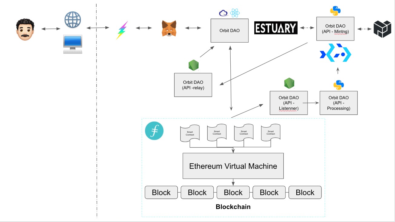
The application starts when the user connects to the internet, connects through Flex and connects to Metamask to interact with the blockchain. Then, the user fills out a form to begin monitoring a protected area or any location with forest coverage, indicating what will be measured. After supplying this information, the user pays 0.02 Matic, which is the cost of monitoring, and the payment goes directly to the Relay, which is the wallet that mints the NFTs. When the smart contract is reached and the transaction is generated, there will be events emitting, which will be constantly listened to by a backend in node. When the transaction is executed, the backend will activate a get request to the Python API for image processing, which will download the images, perform all the processing, atmospheric correction, generate NDVI, measure the area in hectares, and then send them to the Node relay, which is another backend that will store the information to generate the forest coverage graph over time. It will then interact with Bacalhau, which is running a docker image containing the minting process, also running in Python, which is another NFT minting API that processes images to be sent to Estuary and stores the CID in CO2storage to be later sent to the relay for minting the NFTs, which will finally be displayed on the frontend.
How we built it
The first step is preprocessing and downloading images and preparing them for atmospheric correction. The processing first changes the digital numbers (DN) to radiance, because the images from Channel 5, which capture near-infrared, which reflects ground cover, need to be processed. Ground cover reflects near-infrared in Channel 5, while the near-red channel reflects vegetation. This is done for Channel 4 (red) and Channel 5 (near-infrared).
Before this, the RGB image is generated using Channels 2, 3, and 4, which are blue, green, and red. Then, a multi-channel image is created by adding NDVI, which is the calculated plant photosynthetic capacity index using a preset formula, to the RGB channel, so that it can be sent to Bacalhau. After changing the digital numbers to radiance, cloud masking is performed. This is done by using information from the previous record to identify cloud-covered areas and masking them with NaN values, and adding the values of the previous image where there are clouds. This process is repeated for each monitored image.
Then, cloud masking overlaps the previous images, and NDVI is extracted. Only NDVI values greater than 0.6 to 1 are counted as forests because the scientific literature suggests that forests start from 0.6. The area in hectares of the NDVI values between 0.6 and 1 is calculated, and deforestation is monitored through a multi-temporal scale, where forest cover extensions are compared to detect changes in NDVI.
It's worth noting that ecosystems move, so there may be fluctuations. Without a significant number of images, it is difficult to establish a precise variance and determine descriptive or predictive statistics.
This is a brief description of the processing in BIOrbit.
Challenges we ran into
4 big challenges we had in the process
The first challenge we faced in terms of development was the implementation of sustainable and decentralized technologies that allow any forest zone to access monitoring and surveillance tools for forest coverage in a simple way. We believe that we have managed to develop BIOrbit in its most basic and intuitive form thanks to the talent of the team, especially having an ecologist who has previously interacted with monitoring systems. This allowed us to more easily identify pain points in these types of processes and try to solve them.
The scrapping process was quite complex since we did not know that it was possible to do it through javascript
The Processing Script was quite complex, but thanks to the documentation and the technical skill of the team it will be perfected to get
To send a lot of data to the contract, it explodes, and the mint fails due to lack of gas, but when I add more gas to the contract it tells me that I exceed the amount of gas that I can give to the contract; So what we did for that amount of data was to wait for the core to the blockchain; This represents a limitation, not only in the computational capacity of our teams, but also in the blockchain itself.
Accomplishments that we're proud of
🌳🌍🔬- Development of an accessible and affordable tool: Our main goal when creating BIOrbit was to make forest monitoring and surveillance technology accessible and affordable for any forest area that wanted to protect its green areas. We believe we have achieved this goal by creating an affordable and decentralized solution that uses sustainable and user-friendly technologies.
🚀🧪🌐- We built a Decentralized Science (DeSci) tool: BIOrbit is not only a satellite monitoring tool, but also a decentralized platform that uses technologies like blockchain and decentralized storage to ensure data security and transparency. By building this platform, we are promoting the idea of Decentralized Science (DeSci), which means we are democratizing access to technology and promoting collaboration in the scientific community.
🌿💻🔗- We use blockchain technology and infrastructure focused on green markets: As part of our decentralized platform, we use blockchain technologies to store metadata and ensure data transparency. Additionally, we work with Estuary and Bacalhau to securely and sustainably store satellite images and data in the cloud. By doing so, we are contributing to the development of green and sustainable markets.
💻👨💻👩💻- We participated and built in this hackathon: Participating in hackathons and other innovation spaces is important to us because we believe it is in these environments where innovative ideas are born that can truly break paradigms and provide unique solutions. We are proud to have been part of this hackathon and to have built a tool that has the potential to make a significant difference in protecting the environment and fighting deforestation.
What we learned
- Perform the scraping process facilitated through javascript
- Building a script for satellite image processing
- How to use Docker Containers
- We learned that it is not so easy or practical to store large volumes of information in the same package, since for the need that we had to move a large flow of data we must execute small transactions with the distributed packages; We consider that this was one of the limitations of the MVP, at least in testnet
What's next for BIOrbit
Our Roadmap Lite for 2023
Q2 Infrastructure improvement Pilot tests with local parks Construction and improvement of base rates
Q3 Improvement of server infrastructure to optimize image processing in less time Tests for start of measurement in bodies of water (LSWI) Tests for satellite animal monitoring and introduce ourselves to the biodiversity market
Q4 Start of relationship with protocols in carbon and environmental markets Governance token DAO
Built With
- adobe-illustrator
- alchemyapi
- bacalhau
- beautiful-soup
- bootstrap
- docker
- estuary
- ether.js
- fast-api
- figma
- filecoin
- firebase
- flask
- fleek
- gdal
- gis
- git
- hardhat
- javascript
- lansat8
- lansat9
- metamask
- ngrok
- photoshop
- poetry
- postman
- pycharm
- python
- qgis
- react
- redux
- remix
- sass
- selenium
- shell
- solidity
- visual-studio


Log in or sign up for Devpost to join the conversation.