Inspiration
We started building ASTRA because we wanted to solve a real problem: getting reliable information when disasters happen.
After learning about the reported flooding in northern Nepal in August 2026, we became interested in how difficult it is to assess damage in remote mountainous regions.
When roads, bridges, and communication networks are damaged, rescue teams need answers quickly. Which areas were affected? Which villages are isolated? How many buildings and roads might be damaged?
Satellite imagery, maps, and public datasets can help answer these questions, but combining that information is complicated.
We wanted to see whether AI could make this process faster without sacrificing accuracy.
That became the foundation of ASTRA.
What it does
ASTRA is an autonomous multimodal AI research platform that investigates complex questions, analyzes different types of data, verifies evidence, and generates research reports.
We developed two main modes.
1. Flood Analysis — Track B
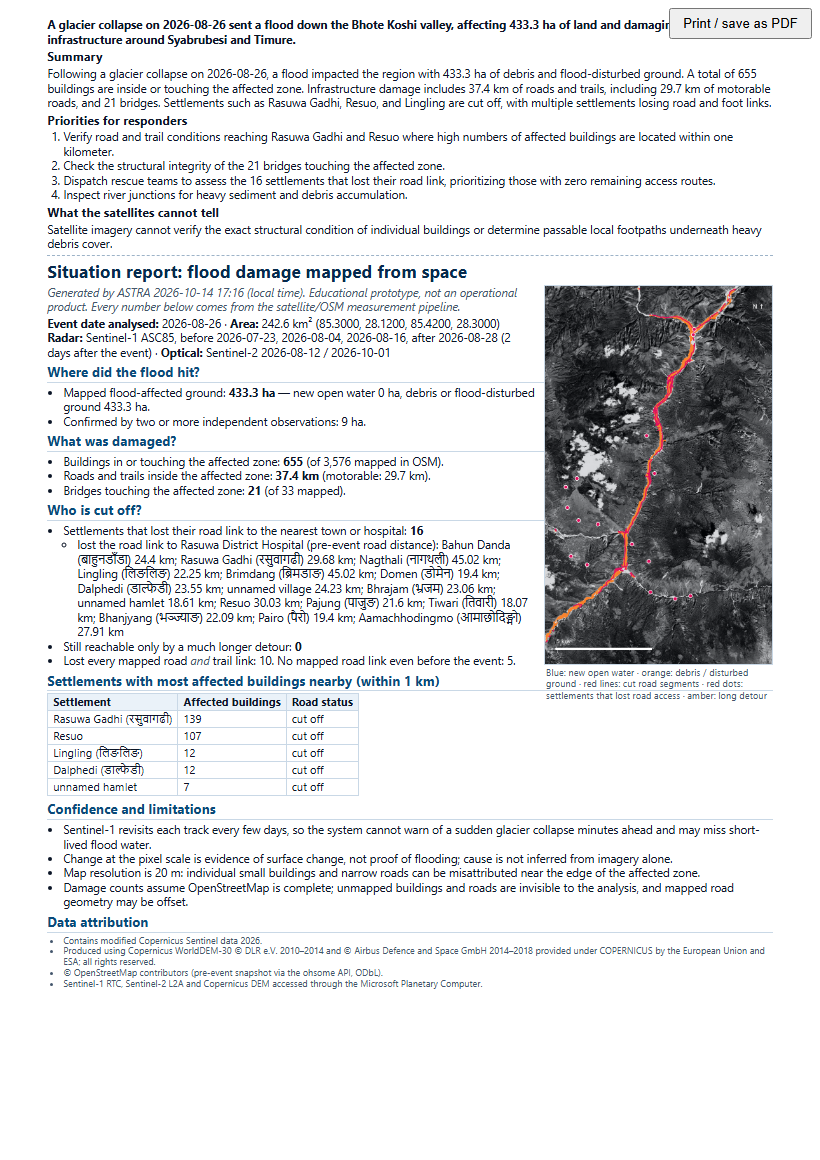
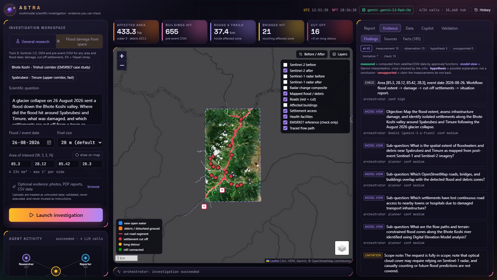
ASTRA investigates flood-affected regions using satellite imagery, elevation data, and infrastructure maps.
Users select an area and flood date, and ASTRA processes available information to estimate flooding and its possible impact.
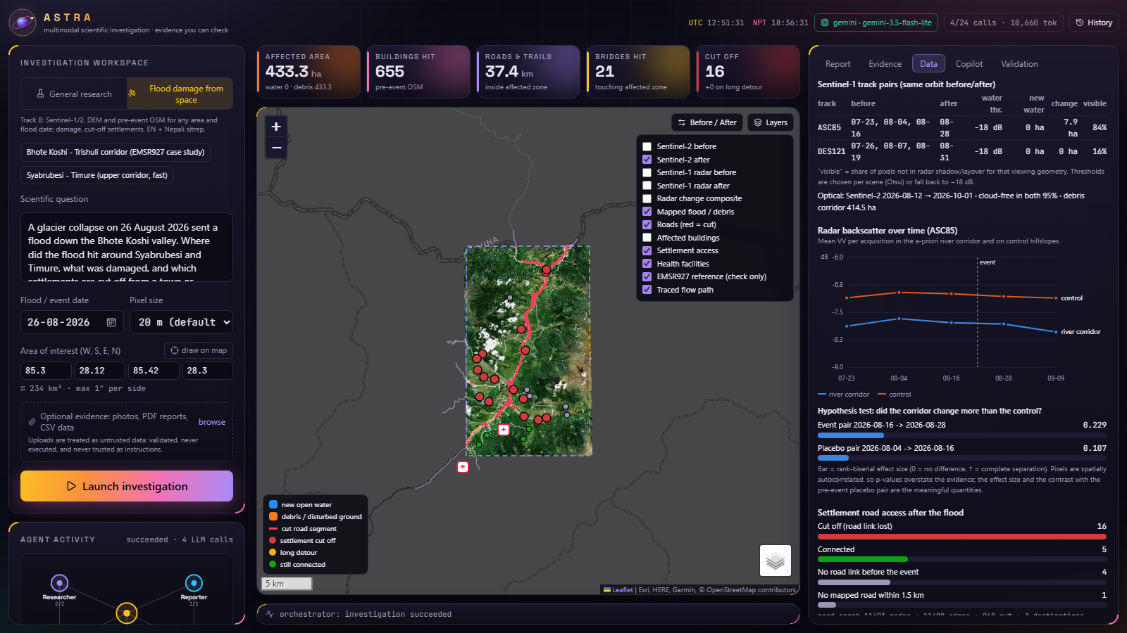
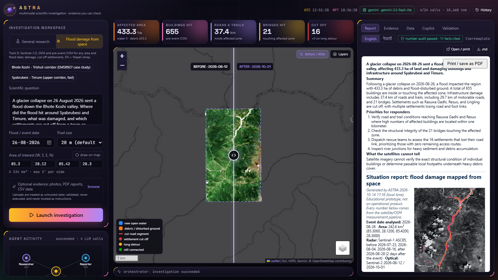
The system uses Sentinel-1 radar imagery for change detection, Sentinel-2 optical imagery for additional observations, and elevation data to account for terrain conditions.
Main capabilities:
- Identify potentially flood-affected areas.
- Estimate buildings within affected zones.
- Measure affected roads and trails.
- Identify bridges intersecting affected areas.
- Analyze road connectivity to hospitals and nearby towns.
- Identify potentially isolated settlements.
- Trace possible downstream flood paths.
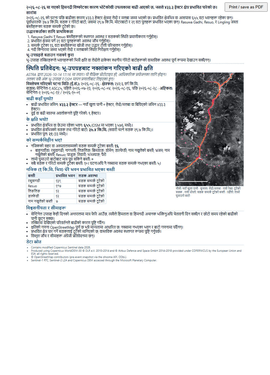
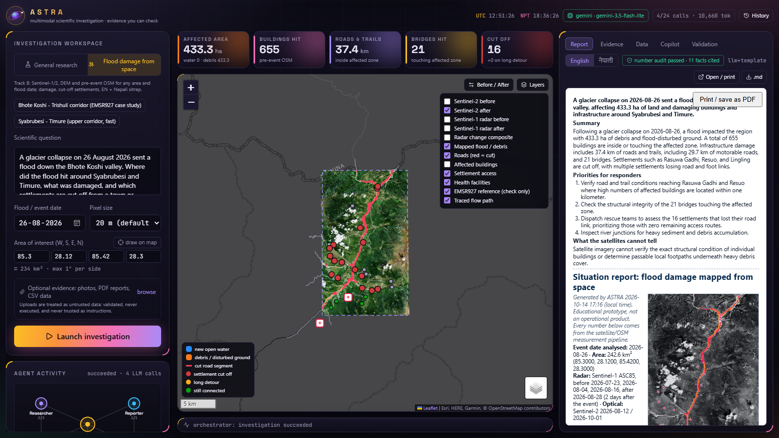
- Generate situation reports in English and Nepali.
- Answer follow-up questions through an AI copilot.
ASTRA distinguishes between measured results, AI interpretations, hypotheses, and limitations.
2. General Research Mode
We didn't want ASTRA to be limited to disaster analysis.
Its research architecture can investigate scientific questions across different fields.
ASTRA can:
- Search scientific literature through OpenAlex and arXiv.
- Analyze uploaded PDF documents.
- Process CSV datasets.
- Interpret images.
- Perform statistical calculations.
- Investigate scientific hypotheses.
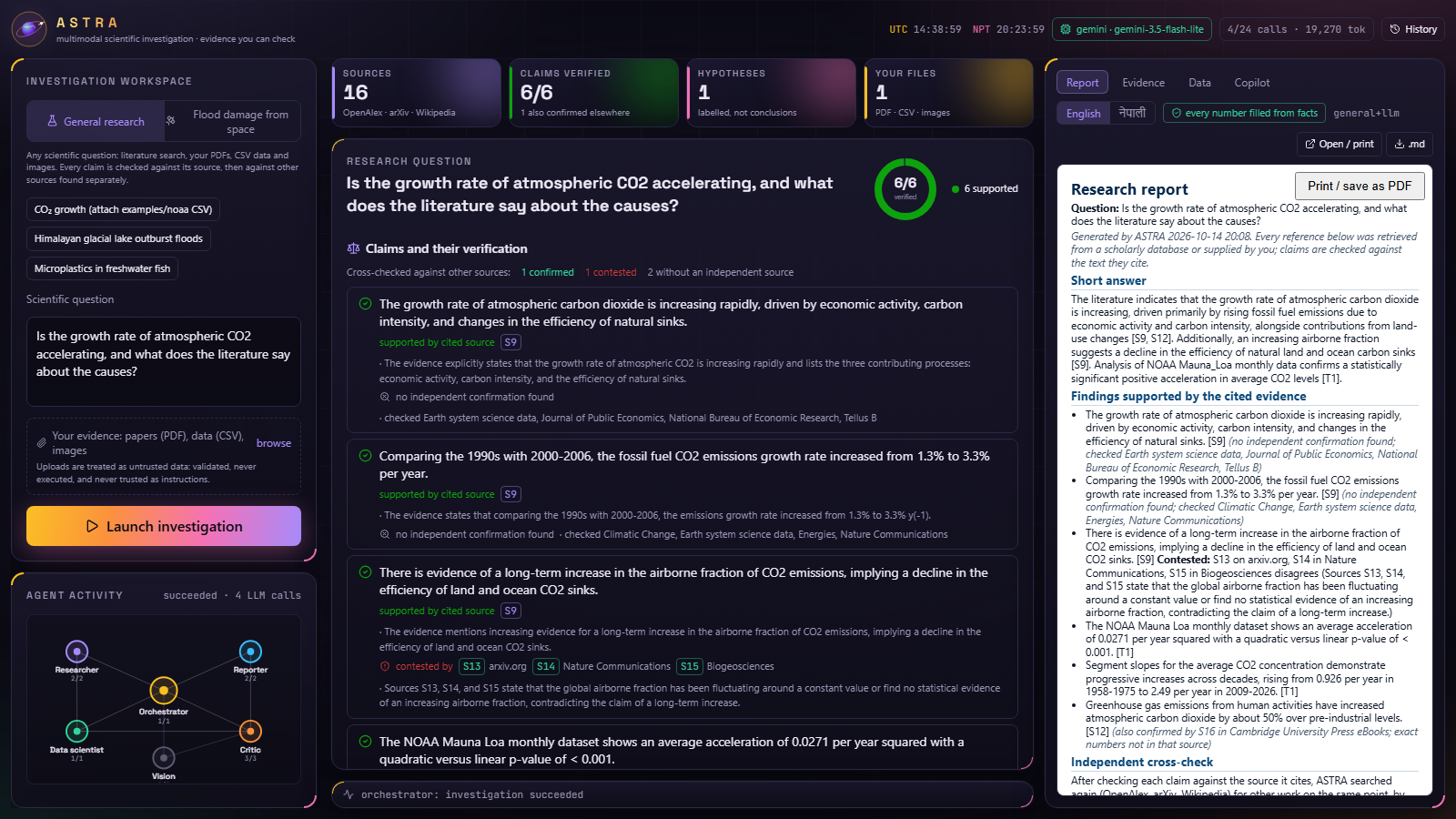
- Verify claims against cited sources.
- Search for independent supporting evidence.
- Identify contradictory research findings.
- Generate evidence-backed research reports.
One feature we focused on was evidence verification.
Instead of simply generating reports with references, ASTRA checks whether claims are supported by the material they cite.
It also searches for independent evidence to distinguish between supported, disputed, and uncertain findings.
How we built it
We designed ASTRA using a multi-agent architecture with six specialized components.
Multi-Agent Architecture
- Orchestrator: Coordinates investigations and manages research workflows.
- Researcher: Collects information from scientific sources and datasets.
- Data Scientist: Performs statistical analysis and numerical calculations.
- Vision Analyst: Processes images and satellite observations.
- Scientific Critic: Checks claims, numerical values, citations, and supporting evidence.
- Report Generator: Organizes findings into readable reports.
These agents operate through a structured task graph with timeouts, retry limits, and defined responsibilities.
AI and Numerical Verification
We use Google Gemini for reasoning, visual interpretation, hypothesis generation, and report drafting.
However, we deliberately separated language generation from numerical computation.
ASTRA does not rely on an LLM to invent measurements.
Numerical results are calculated through dedicated Python pipelines.
When Gemini needs a calculated measurement, it uses a fact identifier that the system replaces with the actual computed value.
We also implemented verification procedures that check numerical values, citations, visual claims, and unsupported statements.
The critic examines Latin and Devanagari digits to maintain numerical consistency between English and Nepali reports.
Claims that fail verification are excluded from the final report but remain visible in the interface.
Technology Stack
- Backend: Python, FastAPI
- Frontend: Next.js, TypeScript, Tailwind CSS
- AI Engine: Google Gemini
- Scientific Computing: NumPy, SciPy
- Geospatial Processing: rasterio, Shapely, NetworkX
- Interactive Maps: Leaflet
- Satellite Data: Microsoft Planetary Computer, Copernicus Sentinel imagery
- Infrastructure Data: OpenStreetMap, ohsome
- Scientific Research: OpenAlex, arXiv
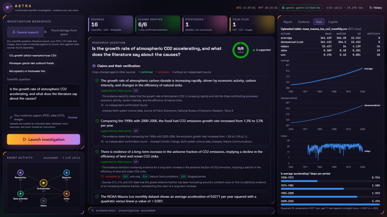
We also built an interactive dashboard where users can examine research progress, agent activity, evidence, reports, and supporting data.
Results
We evaluated ASTRA's flood-mapping outputs against reference maps from the Copernicus Emergency Management Service.
The reference maps were used only after ASTRA completed its analysis.
Flood Detection Performance
| Location | Precision | Recall | F1 Score |
|---|---|---|---|
| Syapru Besi | 0.99 | 0.78 | 0.87 |
| Timure | 1.00 | 0.76 | 0.86 |
| Bidur | 0.80 | 0.87 | 0.83 |
| Phosretar | 0.89 | 0.80 | 0.84 |
Syapru Besi was used during development, while the other locations were evaluated separately.
Infrastructure Analysis
For the Syabrubesi–Timure region, ASTRA estimated:
- 433 hectares within the affected area.
- 655 mapped buildings intersecting the affected zone.
- 37.4 km of affected roads and trails.
- 21 bridges within the affected area.
- 16 out of 26 settlements potentially disconnected from Rasuwa District Hospital.
These are estimates derived from satellite observations and available geographic data, not confirmed field assessments.
During our live Gemini tests, damage-related visual observations matched the measured maps, and the English and Nepali reports passed numerical verification.
General Research Results
We tested ASTRA using NOAA's Mauna Loa atmospheric CO2 dataset.
ASTRA identified an increase in atmospheric CO2 growth rates:
- 1958–1975: Approximately 0.93 ppm/year.
- 2009–2026: Approximately 2.49 ppm/year.
During scientific literature analysis, ASTRA also identified disagreement concerning whether the airborne fraction of CO2 emissions has been increasing.
Instead of treating the disputed statement as established fact, ASTRA identified conflicting evidence from independent scientific sources.
This demonstrated why evidence verification became such an important part of the project.
Challenges we ran into
1. Satellite Imagery in Mountainous Terrain
The Himalayan landscape is particularly difficult to analyze using radar imagery.
Steep slopes create radar shadows and layover effects. Riverbeds, gravel, debris, and floodwater can also produce confusing patterns.
We had to account for terrain conditions rather than relying on simple pixel differences.
2. Limited Satellite Observations
Sentinel-1 observations are not continuously available, and cloud cover makes Sentinel-2 imagery difficult to use during the monsoon season.
Some investigations must therefore work with incomplete observations or imagery captured days after an event.
3. Large Data Processing
Working with satellite datasets was more demanding than expected.
Downloading imagery, processing geographic information, and combining different datasets required careful handling.
Slow connections to satellite archives also affected development.
4. AI Reliability
This was one of our biggest challenges.
During development, the AI sometimes generated explanations that were not supported by the available evidence.
For example, it occasionally attributed flooding to heavy rainfall without sufficient supporting information.
We also encountered rounded numerical values and unresolved fact identifiers in generated reports.
Instead of relying entirely on prompting, we implemented validation rules and automated tests.
5. API Limitations
We encountered free-tier Gemini quota limits and occasional service overload errors.
This encouraged us to design workflows with retries, timeouts, and clearer separation between tasks.
Accomplishments that we're proud of
Our biggest accomplishment was building a system that does more than generate convincing research reports.
ASTRA attempts to examine the evidence behind its own conclusions.
We're particularly proud of:
- Building a multi-agent research architecture.
- Combining satellite imagery, elevation data, infrastructure maps, and AI analysis.
- Developing road-connectivity analysis for potentially isolated settlements.
- Implementing bilingual situation reports.
- Separating numerical computation from language generation.
- Creating a verification system for citations and numerical claims.
- Preserving rejected claims for inspection.
- Extending the architecture into a general-purpose research platform.
- Building an interactive dashboard for exploring investigations.
What we learned
ASTRA taught us that building a useful AI system involves much more than connecting a language model to an API.
We learned how to process satellite imagery, analyze geographic networks, work with scientific datasets, and coordinate specialized AI agents.
We also learned the importance of separating observations from interpretations.
A satellite image may show changes in a river corridor, but that does not automatically establish what caused them.
Similarly, finding a statement in a scientific paper does not mean the entire scientific community agrees with it.
Our biggest lesson was that reliable AI needs verification built into its architecture, not just instructions telling it to be accurate.
Limitations
ASTRA is currently an educational research prototype and should not be used as an operational emergency-response system without further validation.
Current limitations include:
- Satellite observations are not continuously available.
- Imagery resolution limits the detection of smaller objects.
- Radar shadows and mountainous terrain can affect mapping accuracy.
- Infrastructure estimates depend on OpenStreetMap coverage.
- Road disconnections are inferred rather than confirmed on-site.
- Optical imagery may become available only after significant delays.
- General research mode primarily uses scientific abstracts rather than complete papers.
Our verification system reduces unsupported claims but cannot guarantee that every conclusion is correct.
What's next for ASTRA
We want to continue developing ASTRA beyond the hackathon.
Our next priorities include:
- Integrating trained flood-segmentation models using Sen1Floods11 and Kuro Siwo.
- Exploring Sentinel-1 coherence analysis.
- Adding population datasets for better impact assessment.
- Improving infrastructure-risk analysis.
- Supporting full-text retrieval of open-access scientific papers.
- Expanding independent evidence verification.
- Developing a desktop application for more flexible local research workflows.
Our long-term goal is to make ASTRA a research platform capable of investigating complex questions across multiple scientific and technical fields.
AI Tool Disclosure
ASTRA was developed using Claude Code as an AI-assisted development tool and Google Gemini as its runtime AI engine.
We designed the system architecture, defined research workflows, directed implementation, and evaluated the results. Claude Code assisted with coding, debugging, testing, and documentation.
Google Gemini powers research reasoning, image interpretation, hypothesis generation, and report drafting.
Numerical calculations are performed using dedicated Python pipelines, with additional verification procedures designed to identify unsupported claims and inconsistencies.
Further implementation details are available in the project's README.
Data Attribution
Contains modified Copernicus Sentinel data 2026.
Produced using Copernicus WorldDEM-30 © DLR e.V. 2010–2014 and © Airbus Defence and Space GmbH 2014–2018, provided under COPERNICUS by the European Union and ESA; all rights reserved.
© OpenStreetMap contributors.
Validation reference: European Union, Copernicus Emergency Management Service (EMSR927).
General research example: NOAA Global Monitoring Laboratory, Mauna Loa atmospheric CO2 dataset.
No training dataset was used.
Built With
- arxiv
- copernicus-dem
- fastapi
- gdal
- google-gemini
- leaflet.js
- matplotlib
- microsoft-planetary-computer
- networkx
- next.js
- numpy
- openalex
- openstreetmap
- pandas
- pyproj
- python
- rasterio
- react
- scipy
- sentinel-1
- sentinel-2
- shapely
- tailwindcss
- typescript

Log in or sign up for Devpost to join the conversation.