Inspiration
California has recorded millions of agricultural pesticide applications. Yet for the communities living near agricultural land, understanding those records remains incredibly difficult.
The information is scattered across government databases, environmental studies, geographic datasets, and weather services. A parent trying to understand pesticide activity near a school shouldn't need to become a data scientist to find an answer.
We built askgaia to bridge that gap.
Inspired by the growing opportunity to make real-world public data accessible through AI agents, we wanted to create something beyond another environmental dashboard: a living, interactive Earth that people can explore, question, and understand.
What it does
askgaia is an agentic environmental intelligence platform combining geospatial data, interactive 3D visualization, atmospheric modeling, and AI-powered environmental investigation.
1 · Explore a living Earth
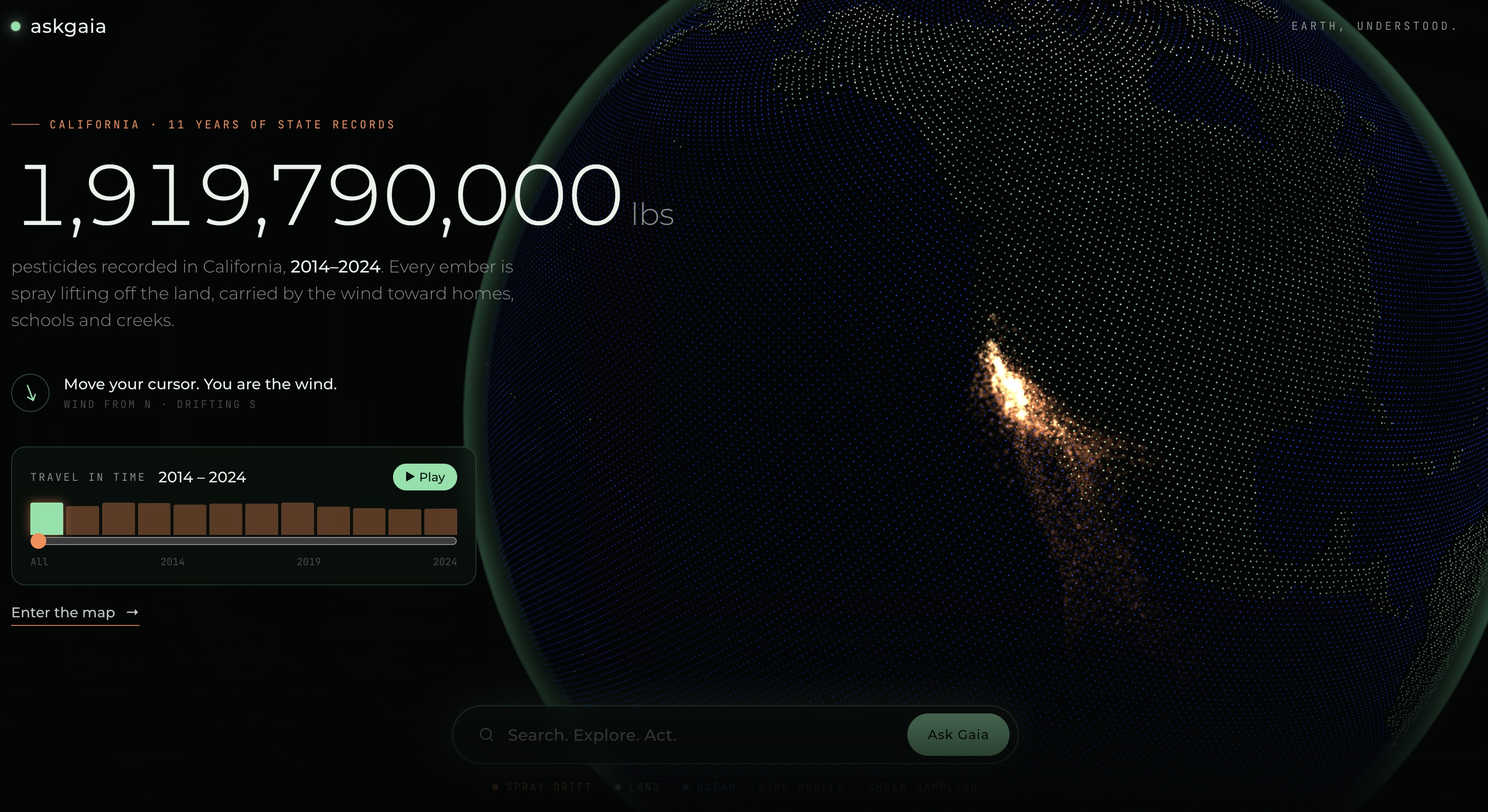
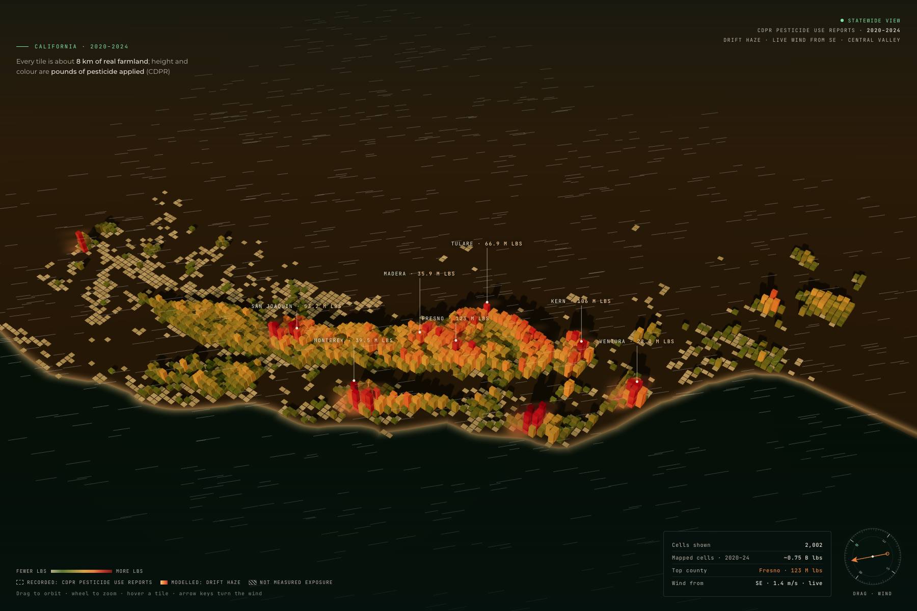
Our particle-based globe visualizes pesticide activity across California, covering 2014–2024.
Users can explore geographic patterns, move through historical records, and transition from a statewide view into real communities.
2 · Experience environmental data through storytelling
Environmental statistics can feel abstract until we connect them to people's lives.
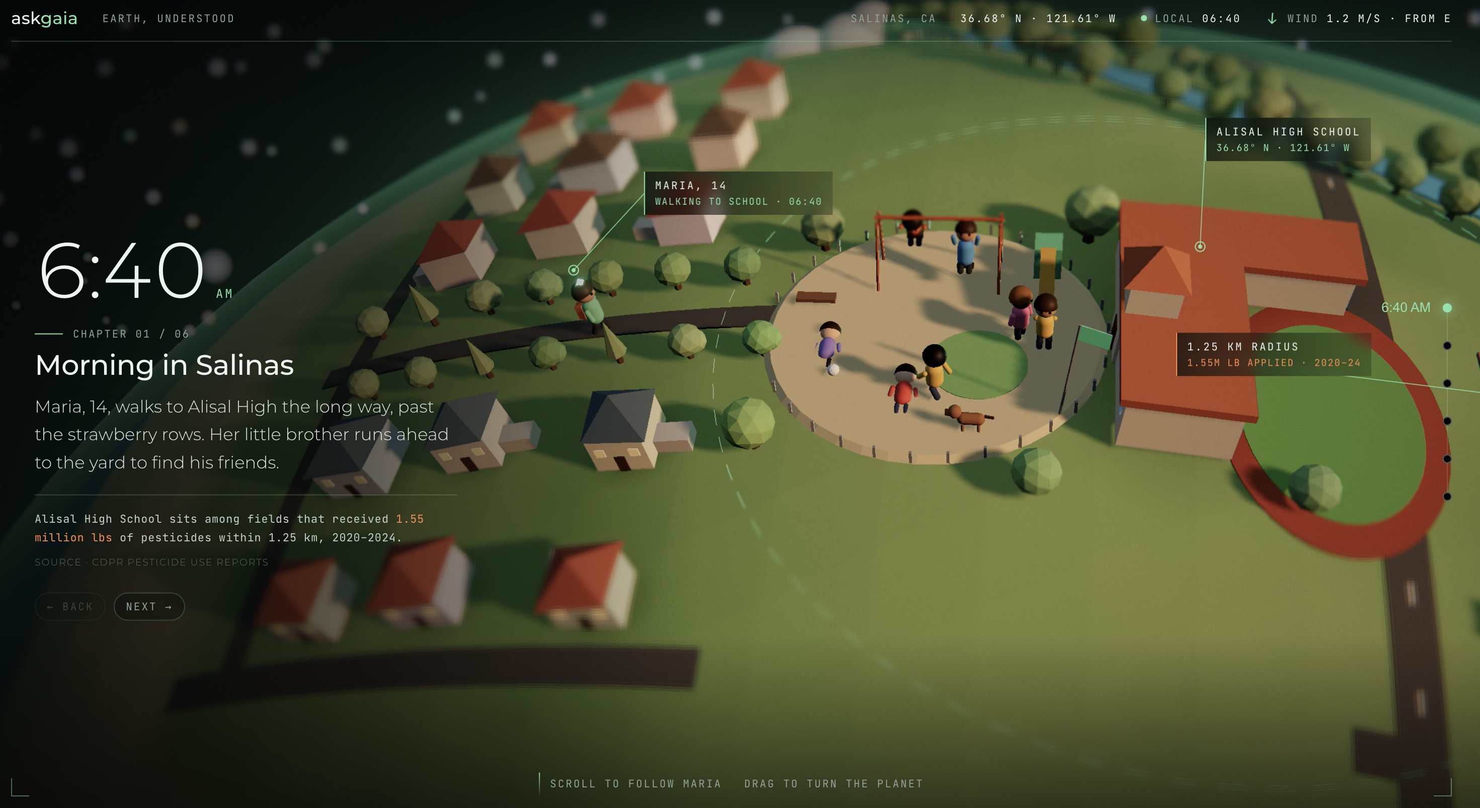
Our immersive 3D narrative follows Maria through a day in Salinas, California, using illustrated scenes to explain potential environmental pathways involving agricultural activity, schools, and waterways.
The story draws on environmental research while distinguishing illustrative scenarios from documented events.
3 · Investigate real places in 3D
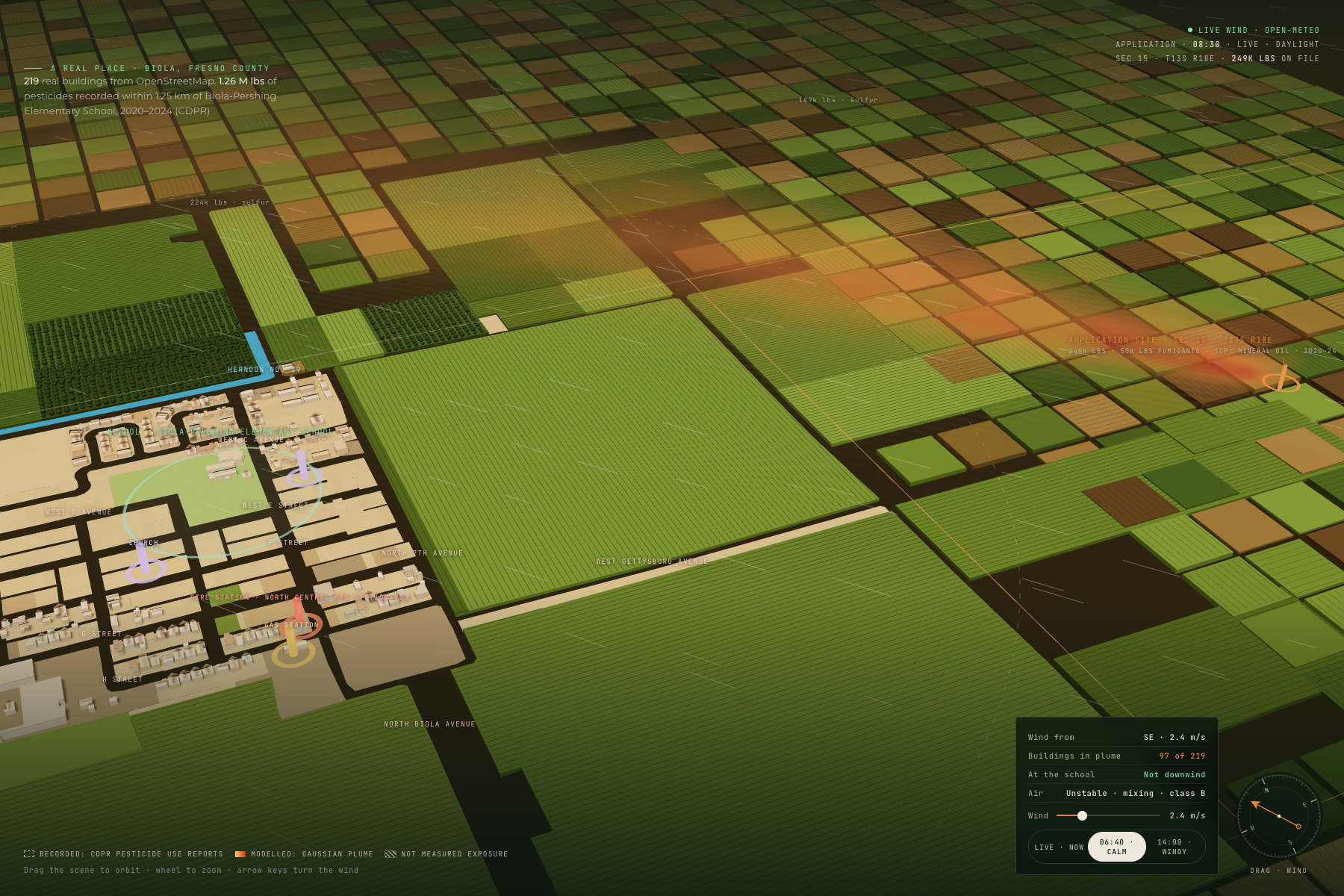
askgaia integrates Google Photorealistic 3D Tiles, OpenStreetMap geographic data, and custom Three.js visualizations.
Users can navigate real California towns, explore recorded pesticide-use activity, and examine nearby buildings, schools, and agricultural areas.
We developed geographic visualizations for communities including Salinas, Biola, Arvin, and Oxnard.
4 · Simulate atmospheric dispersion
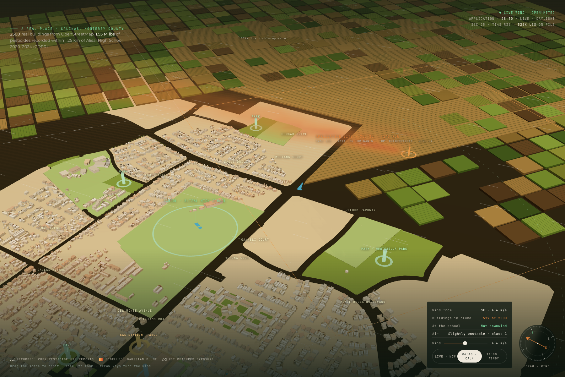
Our environmental modeling combines historical pesticide-use information with live, location-specific weather data from Open-Meteo.
Using Gaussian plume dispersion and Pasquill–Gifford atmospheric stability classes, we visualize scenarios showing how changing wind and atmospheric conditions could influence modeled dispersion.
The platform explicitly distinguishes recorded pesticide use, modeled drift, and measured human exposure.
5 · Ask Gaia: an AI environmental investigator
Users can investigate environmental questions in natural language, for example:
"What do pesticide records show near Alisal High School?"
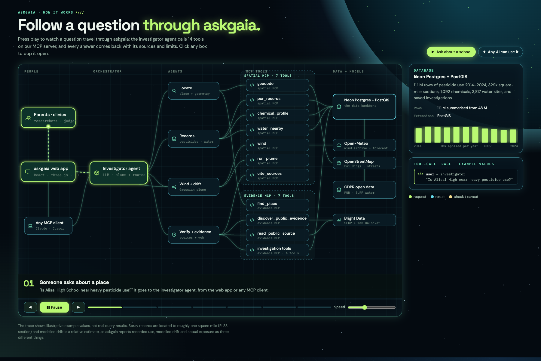
Our investigator agent identifies relevant information, calls specialized MCP tools, queries environmental databases, retrieves public evidence, and constructs explanations grounded in its tool results.
It can investigate pesticide records, chemical information, nearby water-monitoring sites, weather conditions, and relevant public sources.
The goal is to make environmental investigation conversational without sacrificing scientific transparency. We bring 11 years of California pesticide-use records into an explorable digital representation of the Earth.
How we built it
We combined large-scale data engineering, geospatial computing, environmental modeling, AI agents, and 3D graphics into a single application.
Neon + PostGIS: the environmental data backbone
Neon is central to how askgaia works.
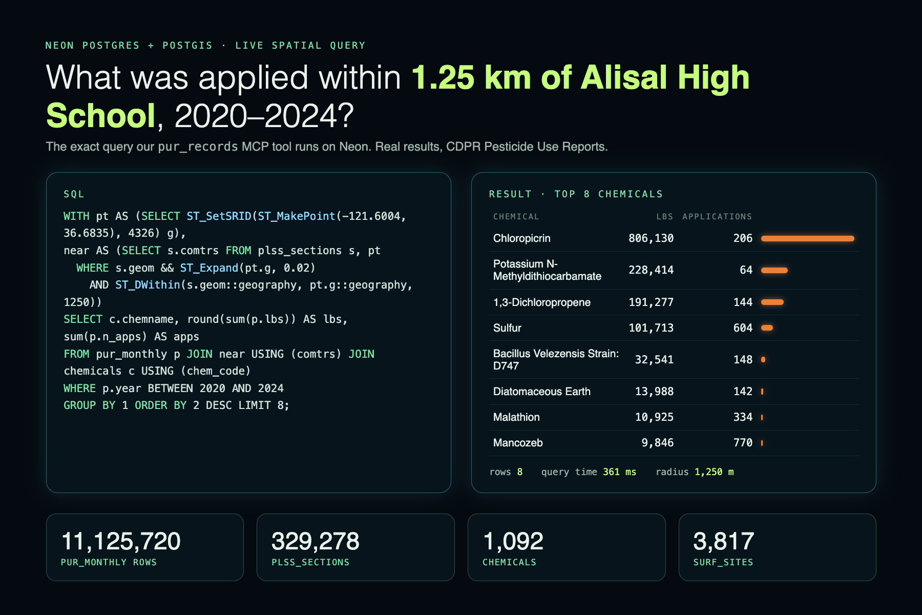
We processed California Department of Pesticide Regulation datasets for 2014–2024 and organized them using Neon serverless PostgreSQL with PostGIS.
Our data infrastructure contains:
- 11.1 million summarized pesticide-use records, derived from approximately 48 million raw records
- 329,278 geographic land sections
- 1,092 chemical substances
- 3,817 surface-water monitoring sites
- 96,648 pesticide detection records
PostGIS enables us to connect environmental records with real geographic locations through spatial queries. Rather than merely storing historical information, we use these capabilities to investigate questions about specific communities and their surrounding environments.
MCP: connecting AI to environmental tools
We built one MCP server using FastMCP, exposing 14 tools across two specialized toolkits.
Spatial toolkit (7 tools): geocode, pur_records, chemical_profile, water_nearby, wind, run_plume, cite_sources
These tools handle geographic queries, pesticide records, chemical profiles, nearby water measurements, weather, dispersion modeling, and citations.
Evidence toolkit (7 tools): find_place, discover_public_evidence, read_public_source, get_county_records, get_investigation, explain_finding, check_source_change
These tools support public-source discovery, retrieval, investigation history, county data, and evidence verification.
Ask Gaia is powered by Google Gemini, enabling users to ask environmental questions in natural language. Gemini connects to our 14 MCP tools to retrieve pesticide records, investigate chemical information, analyze geographic data, and generate evidence-backed responses with source references.
Our existing environmental investigation infrastructure also supports OpenAI-powered agent workflows.
The same MCP tools can also be used by compatible external AI clients such as Claude Desktop and Cursor.
Bright Data: expanding public environmental evidence
We integrated Bright Data's SERP API and Web Unlocker through our evidence toolkit.
This allows the investigator to discover and retrieve relevant public information that complements structured environmental records.
Publicly retrieved information is treated as evidence requiring evaluation, rather than automatically being accepted as fact. This integration helps connect government datasets with broader environmental context.
Building the interactive Earth
Our frontend combines React, Vite, Three.js, WebGL, custom shaders, and 3d-tiles-renderer.
We use Google Photorealistic 3D Tiles alongside OpenStreetMap and OpenFreeMap data to build immersive geographic scenes.
Our Python/FastAPI backend provides geographic data, spatial analyses, county summaries, and modeling endpoints.
Challenges we ran into
Processing environmental records at scale
Working with approximately 48 million raw records meant addressing data volume, duplication, storage limitations, and efficient query performance.
We reduced the dataset into approximately 11.1 million summarized records while preserving the information needed for our investigations.
Integrating multiple 3D systems
Combining geographic tiles, custom Three.js objects, interactive controls, and environmental overlays introduced challenges involving camera orientation, coordinate alignment, rendering performance, and asynchronous loading.
Building trustworthy environmental AI
Environmental information is rarely straightforward.
Historical pesticide reporting does not establish exactly when an application occurred or whether a particular person was exposed.
We designed our investigation workflow to make those distinctions explicit and to preserve source references and uncertainty.
Accomplishments that we're proud of
We're proud of creating more than a conventional dashboard. We built:
- An explorable, visually rich Earth connecting millions of environmental records to real places
- A 14-tool MCP architecture that makes environmental investigation accessible to AI
- Geospatial simulations incorporating live weather context
- Environmental storytelling that makes complex data understandable
- A reusable data infrastructure powered by Neon and PostGIS
- Public evidence discovery using Bright Data
Our biggest accomplishment is connecting environmental data, computational modeling, and AI into one experience that people can actually explore.
What we learned
Building askgaia taught us how challenging it is to connect physical-world datasets with interactive AI systems.
We explored geospatial data engineering, PostGIS optimization, tool orchestration, WebGL graphics, and environmental modeling.
We also learned that responsible environmental intelligence requires understanding the limitations of every source, not simply presenting more data.
What's next for askgaia
Today, askgaia helps communities understand what happened in the past. Our long-term vision is to help them understand what's happening now.
We envision a secure Farmer Portal and Real-Time Application Registry through which participating agricultural operators could report planned or ongoing pesticide applications.
Rather than relying exclusively on delayed historical records, askgaia could incorporate timely application details, including location, product information, and application timing.
In collaboration with agricultural communities and potentially the California Department of Pesticide Regulation (CDPR) and County Agricultural Commissioners, we want to explore integrations with existing reporting systems and incentives for voluntary participation.
This could enable:
- Real-time environmental scenarios: simulating potential downwind dispersion using timely application information and local weather
- Farmer-facing intelligence: helping agricultural operators explore environmental conditions and nearby sensitive locations
- Community awareness: providing relevant, verified updates to participating communities and schools
- Collaborative environmental monitoring: connecting farmers, researchers, regulators, and residents through shared environmental information
- Expanded environmental coverage: incorporating drinking-water, air-quality, soil, and other environmental data
Such a system would require regulatory coordination, reliable reporting, privacy safeguards, and careful validation before supporting operational decisions or public alerts.
Our ambition is to move from understanding historical environmental activity to enabling timely, evidence-based environmental awareness.
Because environmental data shouldn't only tell us what happened. It should help us ask better questions about what happens next.
askgaia. Earth, understood.
Built With
- 3d-tiles-renderer
- bright-data
- fastapi
- fastmcp
- google-maps
- javascript
- mcp
- neon
- open-meteo
- openai
- openstreetmap
- postgis
- postgresql
- python
- react
- three.js
- vite
- webgl
