
Demo Video Alternative Link:
https://www.youtube.com/watch?v=yFCbNTKBmeo
AquaPulse-OneHealth
Urban Freshwater Telemetry & Vector Surveillance Platform
Track
- Track 1: AI-Supported Assessment of Urban Aquatic Ecosystems AquaPulse OneHealth integrates multimodal artificial intelligence to evaluate stream health from citizen field notes, visual imagery, and physical-chemical measurements.
- Track 2: Resilience Informatics for Public and Environmental Health The platform processes ecological indicators to quantify vector-borne disease risks and generate operational action plans for both municipal planners and local communities.
Problem
Urban aquatic ecosystems suffer from fragmented data collection, non-point source pollution, and rapid vector-borne disease proliferation. Traditional laboratory sampling is costly, periodic, and slow to inform public health officials. Consequently, local governments lack actionable telemetry, while citizen scientists remain disconnected from municipal decision-making processes.
Solution
AquaPulse OneHealth provides an end-to-end telemetry ingestion and diagnostic engine. It converts physical observations, bio-indicator counts (such as macroinvertebrates and mosquito larvae), chemical readings, and field photos into standardized health metrics.
Using a combined analytical approach—deterministic scoring models paired with multimodal LLM diagnostics—the platform produces immediate public health alerts, dual-tiered intervention strategies, and geospatial risk mapping.
Target Users
- Municipal Health & Environmental Officers: Receive structured policy recommendations, pollution discharge warnings, and targeted intervention strategies.
- Urban Planners & Hydrologists: Monitor watershed integrity and spatial trends via live GIS mapping.
- Citizen Scientists & Stream Stewards: Submit field telemetry, verify site conditions using photo submissions, and track community engagement via points and leaderboards.
Impact
- Accelerated Hazard Detection: Reduces the delay between field observations and municipal alerts from weeks to seconds.
- Dual-Action Guidance: Automatically generates distinct, actionable steps for city authorities (e.g., stormwater channel inspections) and citizens (e.g., removing standing water).
- Data Standardization: Aligns raw telemetry with One Health principles and FHIR-compatible data models for interoperability with broader public health software.
Alignment with Evaluation Criteria
1. How Your Solution Aligns with OneAquaHealth
AquaPulse-OneHealth directly operationalizes the OneAquaHealth framework by linking urban aquatic ecosystem health with human public health and environmental resilience:
- Holistic Interconnection: It connects physical/chemical water quality (turbidity, pH) and ecological bio-indicators (macroinvertebrate populations) to vector disease risks (mosquito breeding) and human well-being metrics.
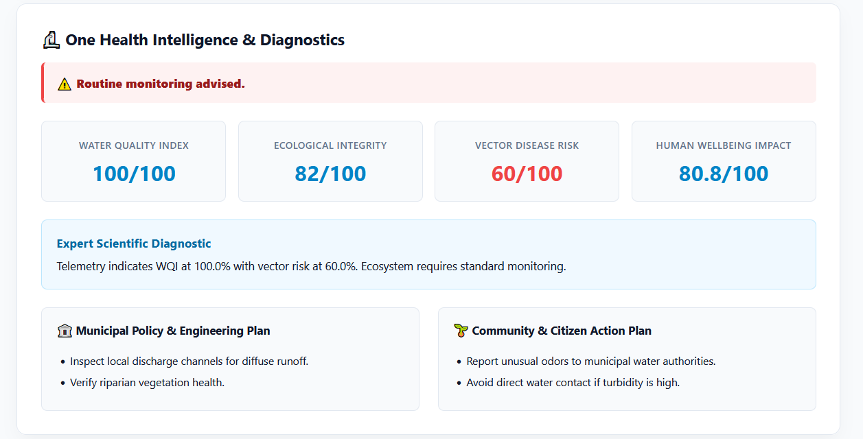
- Dual-Tiered Actionability: Translates complex ecological telemetry into immediate, complementary operational plans—policy-level interventions for municipal authorities and community-level mitigation steps for citizens.
- Standards-Based Interoperability: Implements HL7 FHIR-aligned data schemas to ensure ecological and vector telemetry can directly feed into broader healthcare and municipal health systems.
2. Innovation and Practical Value
- Hybrid Diagnostic Engine: Blends deterministic environmental scoring (WQI, EII, Vector Risk) with generative multimodal AI to deliver fast, reproducible, and context-aware risk evaluations.
- Closing the Citizen-to-Government Gap: Replaces slow, weeks-long laboratory workflows with instant, photo-verified field assessments powered by citizen scientists.
- Gamified Community Engagement: Features a built-in incentive system with points and leaderboards to maintain long-term user participation and high-density spatial data collection.
- Actionable Spatial Intelligence: Interactive GIS mapping transforms raw data points into actionable hotspot visualizations for rapid emergency and municipal planning.
3. Effective Use of Data, Technology, AI, APIs, & Standards
- Multimodal Visual AI (Google Gemini 2.5 Flash): Analyzes user-submitted field photos in real time to verify self-reported turbidity, stream degradation, and discharge presence against field notes.
- Vector Risk Predictive ML (Hugging Face Service): Utilizes specialized machine learning microservices to infer vector-borne disease transmission potential from bio-indicator counts.
- Robust Enterprise Stack (FastAPI & Pydantic v2): Implements an asynchronous, highly scalable Python backend using Pydantic v2 for strict data validation and instant API responsiveness.
- Geospatial & Interoperability Standards: Leverages Leaflet.js and OpenStreetMap APIs for frontend GIS rendering, alongside HL7 FHIR R4 schemas for standardizing environmental health records.
Key Results & Capabilities
- Deterministic Index Computation: Calculates Water Quality Index (WQI), Ecological Integrity Index (EII), Vector Disease Risk Score, and Human Wellbeing Impact.
- Multimodal Image Verification: Decodes field photographs via Gemini Vision to cross-verify reported turbidity, vegetation, and discharge source presence.
- Geospatial GIS Tracking: Maps telemetry collection points on an interactive layer to highlight disease risk hotspots and stream degradation zones.
- Community Incentive System: Tracks user submissions, awards points, and calculates steward ranks to maintain high engagement in citizen science programs.
Tech Stack
- Backend: Python 3.12, FastAPI, Pydantic v2, Uvicorn
- AI Engine: Google GenAI (Gemini API)
- Frontend: HTML5, CSS3, Vanilla JavaScript (ES6+)
- Geospatial Visualization: Leaflet.js, OpenStreetMap API
- Data Standards: JSON, FHIR alignment
Prerequisites
Ensure the following tools are installed on your environment before setup:
- Python: Version 3.10 or higher
- Package Manager:
pip - API Access: Active Google Gemini API key
- Hugging Face API Key
Demo Video Alternative Link: https://www.youtube.com/watch?v=yFCbNTKBmeo

Log in or sign up for Devpost to join the conversation.