-
-

Homepage
-
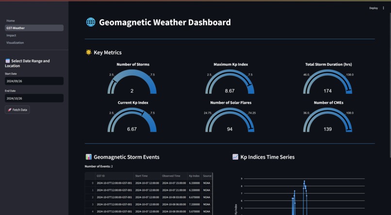
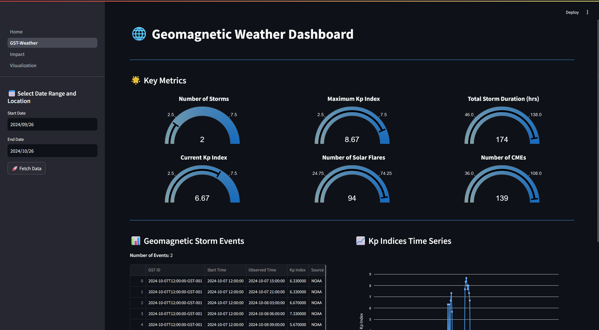
Dashboard
-
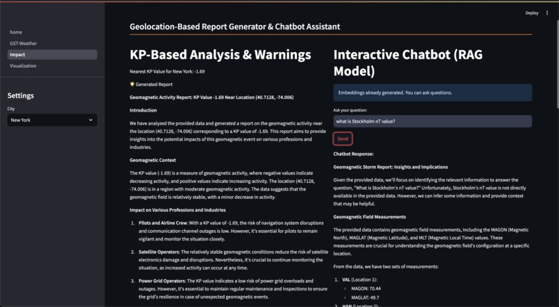
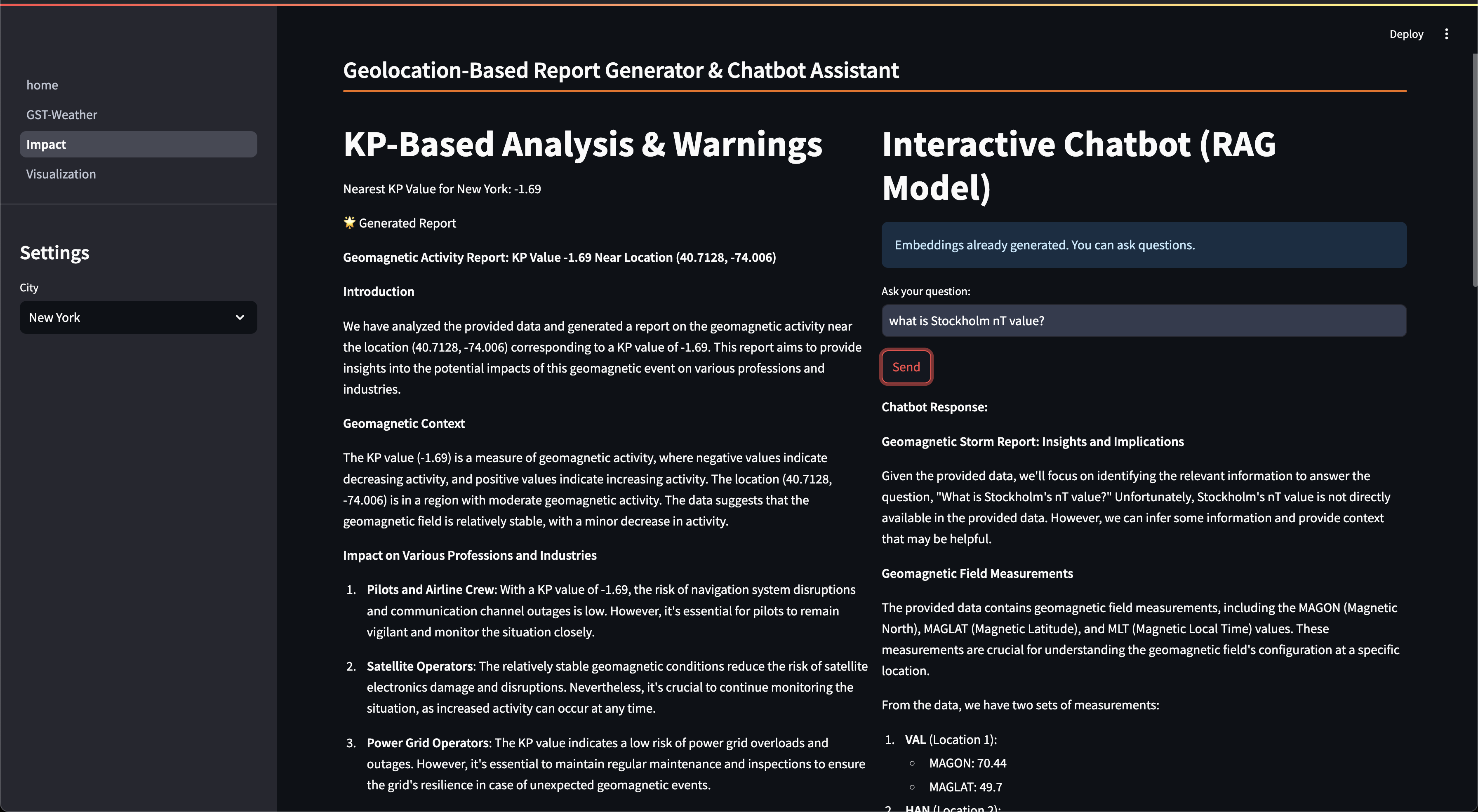
RAG Analysis
-

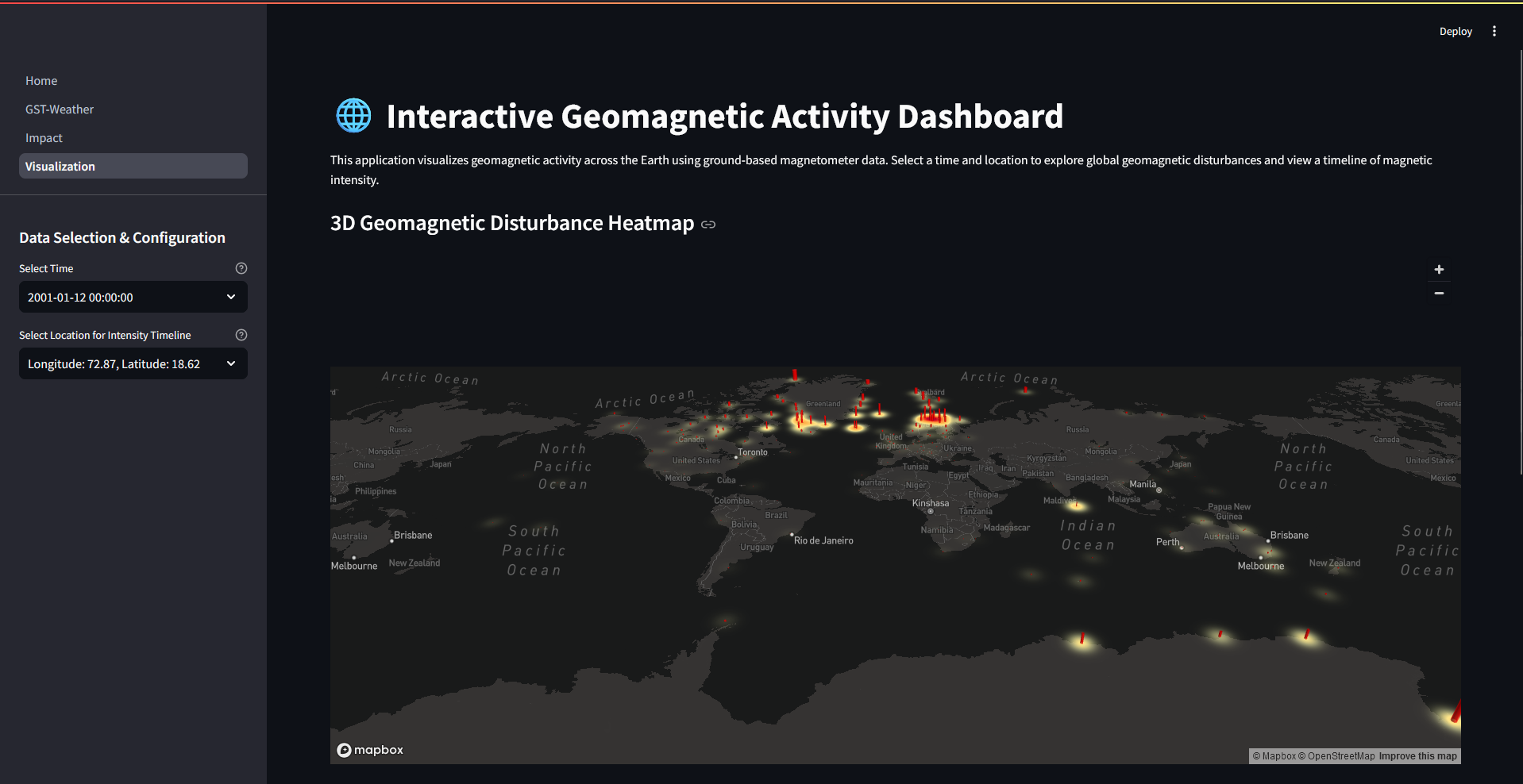
Heatmap
-
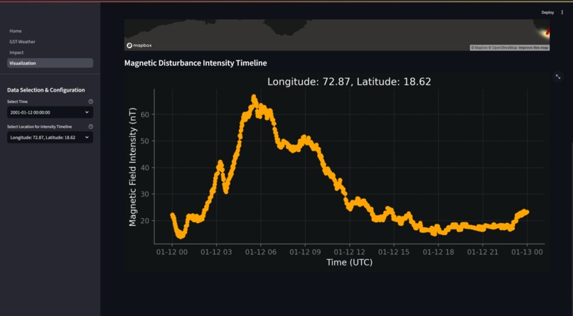
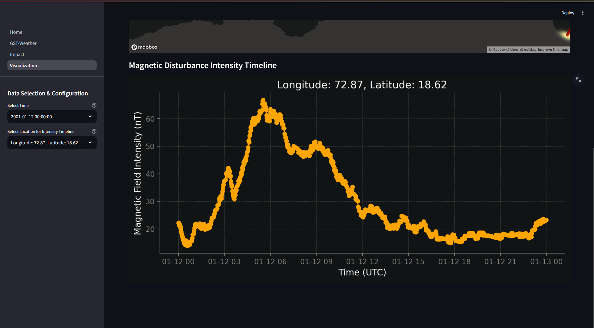
Timeline
Apollo Assist: A Real-time Geomagnetic Weather App
Inspiration
Space weather, especially solar flares and geomagnetic storms, poses serious threats to modern infrastructure. From communication blackouts to potential power grid failures, the stakes are high. Imagine the risks: a single solar event could disrupt the CIA's communication systems, destabilize nuclear defense protocols, threaten airline safety, or result in billions of dollars lost in data centers. We created Apollo Assist to make complex space weather data accessible and actionable, empowering essential industries—from emergency services to power grid operators and aviation—to anticipate and prepare for these cosmic challenges before they turn into real-world crises.
What It Does
Apollo Assist monitors real-time solar activity and translates it into clear, actionable insights tailored for critical systems. Apollo Assist provides threat levels that are easy to understand, so organizations can act before a crisis strikes. With an interactive heat map and advanced RAG-powered analysis, users can visualize both current and historical space weather impacts, empowering them to assess and mitigate risks with precision and confidence.
Key Features
Real-Time Space Weather Data: Fetches GST, FLR, and CME data from NASA’s DONKI API.
3D Geomagnetic Disturbance Visualization: Displays an interactive global heatmap of geomagnetic disturbances.
Impact Analysis: Offers insights into space weather’s effects on professions like pilots, astronauts, satellite operators, and power grid managers.
Dynamic Dashboard with Key Metrics: Includes gauge charts and time series tracking storm durations, Kp indices, and solar activity metrics.
RAG-Based Model: Leverages a specialized RAG model for quick responses on space weather impacts, assisting users in radiation mitigation strategies.
How We Built It
Dashboard: Developed with Streamlit for real-time threat monitoring and intuitive data display.
Visualization: Leveraged Mapbox for interactive, geographic heat maps that highlight impacted areas.
Data Sources:
- NASA DONKI API: Provides detailed records of geomagnetic storms (GST), solar flares (FLR), and coronal mass ejections (CME).
- NOAA Space Weather Prediction Center: Supplies current space weather conditions.
Analysis: CerebrasAI-powered Retrieval-Augmented Generation (RAG) model for rapid, actionable insights.
What We Learned
- Implementing RAG models with Cerebras for specialized analyses.
- Applying geographic visualization techniques with Mapbox.
- Integrating diverse space weather data sources.
- Deepened understanding of the impact of space weather on modern electronics and communications.
Tech Stack
- Frontend: Streamlit, HTML, CSS, JavaScript
- Backend: Python (Pandas, Requests, Numpy)
- AI/ML: Cerebras, Weaviate
- Visualization: Mapbox, Plotly, Pydeck, Matplotlib
- Data Sources: NASA DONKI API, OpenStreetMaps API, SuperMAG API
Challenges We Faced
- Translating scientific space weather data into practical, user-friendly threat levels.
- Crafting meaningful geographic visualizations of space weather impact.
Accomplishments We're Proud Of
- Created a tool that can help safeguard critical infrastructure worldwide.
- Developed a robust system that aggregates data from multiple sources for comprehensive space weather analysis.
Built With
- cerebras
- css3
- html5
- javascript
- mapbox
- matplotlib
- nasa-donki-api
- numpy
- openstreetmap
- pandas
- plotly
- pydeck
- python
- requests
- streamlit
- supermag
- weaviate


Log in or sign up for Devpost to join the conversation.