-
-

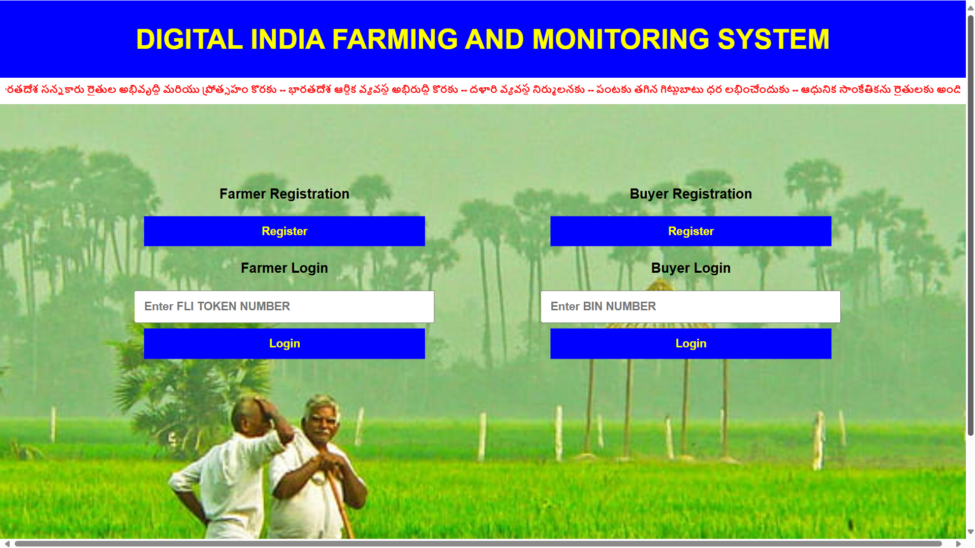
Digital farming platform with Farmer and Buyer login, enabling crop monitoring, smart cultivation decisions, and direct market linkage.
-
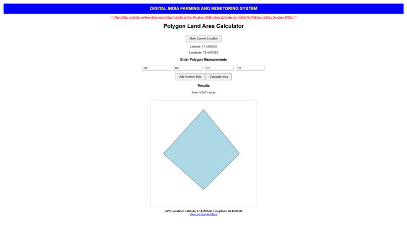
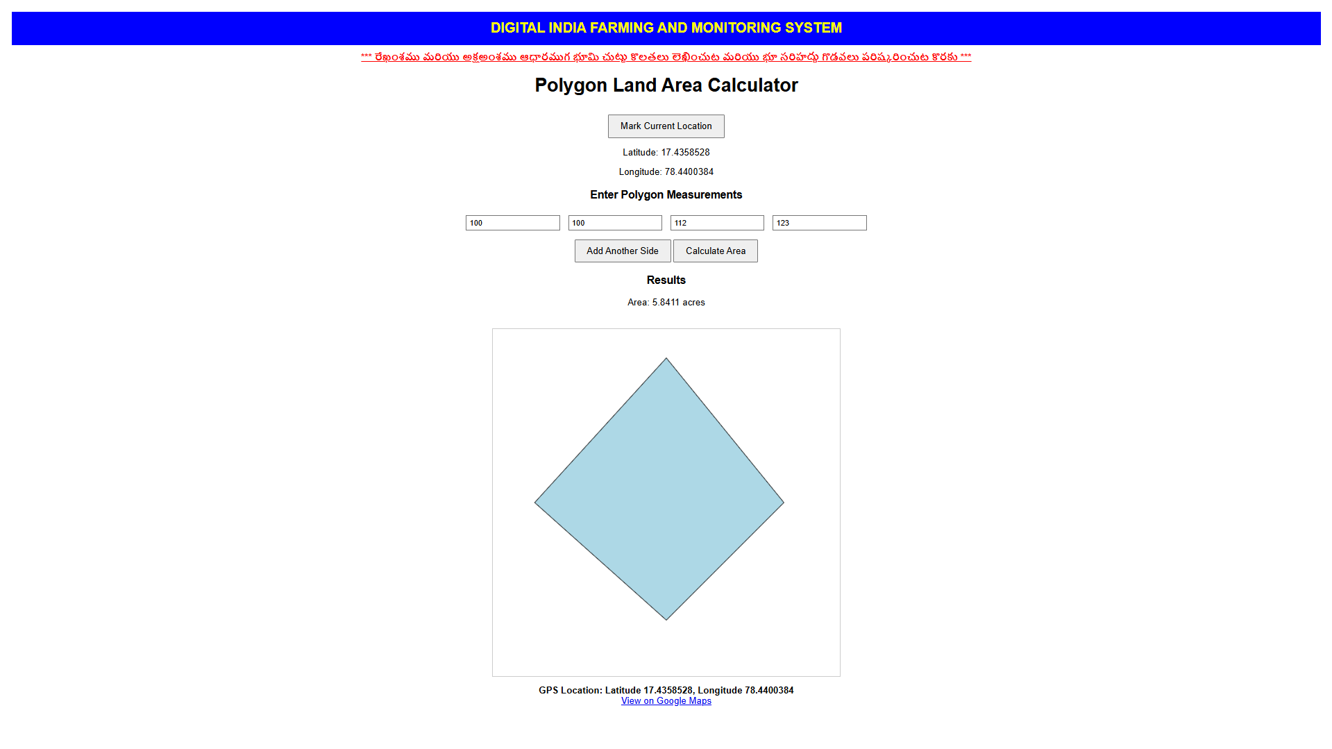
GPS-based polygon area calculator measures farm land boundaries accurately using live location mapping data.
-

AI system analyzes satellite, soil, and market data to suggest best demand crops and allows farmers to enroll cultivation details.
-

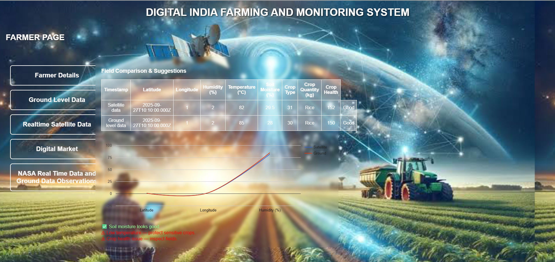
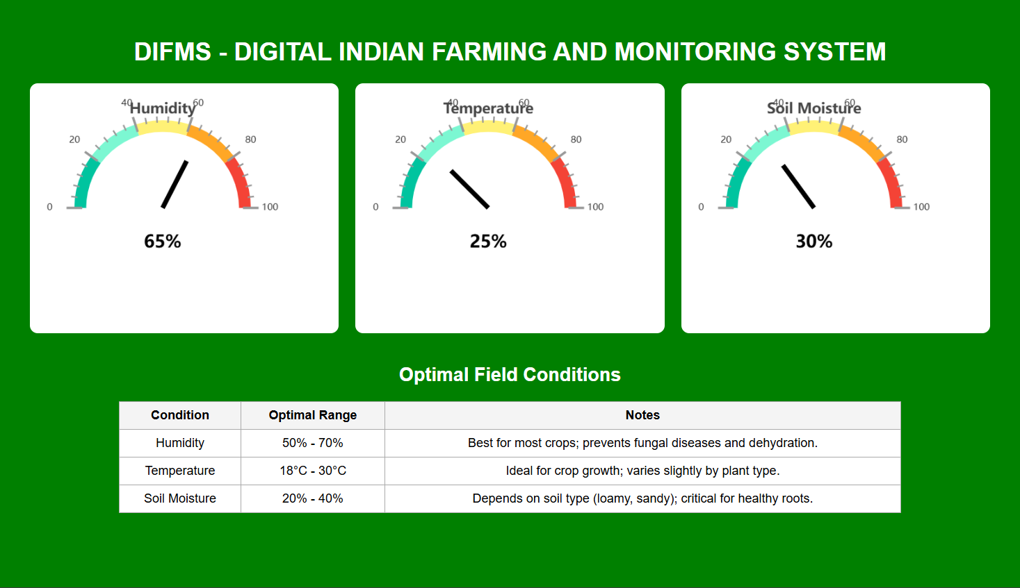
Farmer dashboard to monitor crops, soil moisture, GPS land data, and control irrigation motors with AI-based farming insights.
-
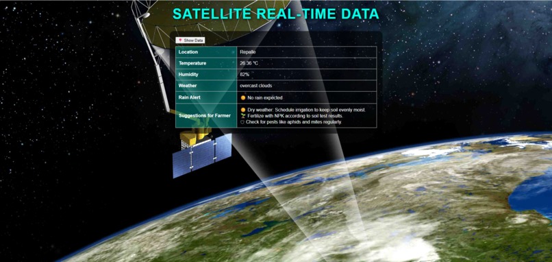
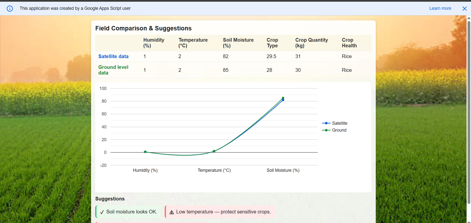
Collects real-time satellite and ground-level data to perform advanced analysis and deliver accurate crop and farm insights
-
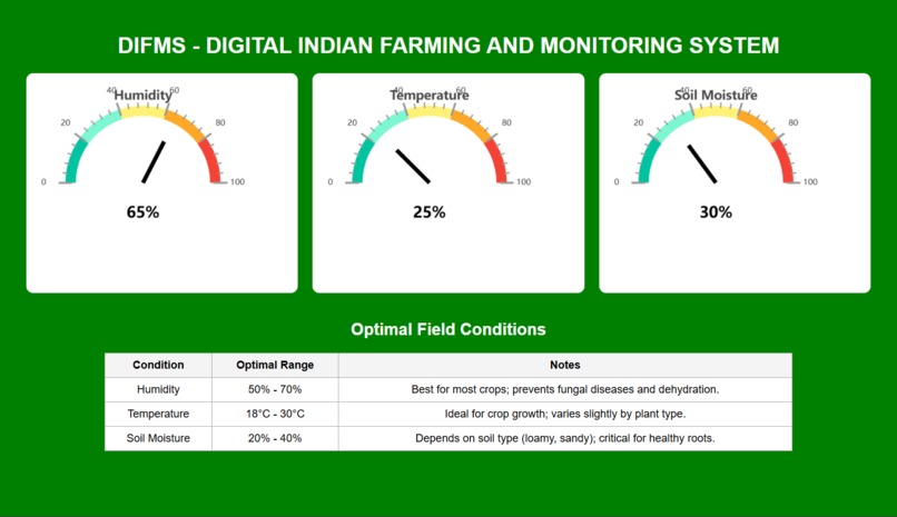
Collects real-time ground-level farm data through sensors and field inputs for accurate crop monitoring and AI analysis.
-

AI performs best crop analysis using satellite imagery and ground sensor data to optimize yield, health monitoring, and profitability.
-
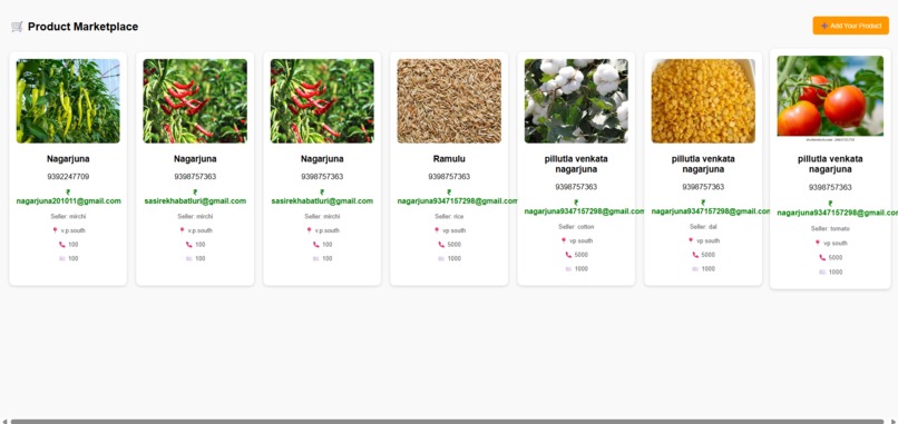
Global digital farming market connects farmers to worldwide demand, enabling better crop pricing, export opportunities, and profit growth.


🌱 Inspiration
The inspiration behind AgriPulse AI came from my uncle, a farmer who faced continuous challenges in agriculture despite his hard work.
He struggled with selecting the right crop, maintaining proper soil moisture, choosing suitable fertilizers and pesticides, and selling produce at the best market price. I observed that he was not using modern technologies due to lack of access and awareness.
Seeing his difficulties motivated me to build a Digital Farming Monitoring System that uses AI, satellite data, and ground-level insights to support farmers in making smarter decisions.
🚜 What it does
AgriPulse AI is a Gemini-powered smart digital farming platform that monitors agricultural activities and provides intelligent recommendations.
The system:
- Analyzes ground-level real-time sensor data
- Integrates satellite imagery insights
- Predicts the most suitable crops
- Suggests high market-demand crops
- Monitors crop health and moisture
- Recommends fertilizers and pesticides
- Tracks farm boundaries using GPS
- Supports government scheme targeting
- Assists in disaster damage assessment
- Enables crop insurance validation
- Provides global agricultural market insights
It acts as a complete digital assistant for farmers.
🛠️ How we built it
We built AgriPulse AI as a web-based digital agriculture platform integrating multiple technologies.
Key development components include:
- Ground data collection using IoT sensors
- GPS-based farm boundary mapping
- Satellite imagery integration
- AI analytics powered by Gemini
- Crop prediction algorithms
- Market demand analysis models
- Monitoring dashboards
Google Cloud services and mapping APIs were used to manage geospatial and agricultural datasets.
⚡ Challenges we ran into
During development, we encountered several challenges:
- Collecting accurate real-time ground sensor data
- Mapping satellite imagery to small land parcels
- Handling climate variability in predictions
- Designing reliable crop suitability models
- Integrating GPS boundary mapping
- Aligning crop suggestions with market demand
- Ensuring usability for non-technical farmers
Overcoming these challenges strengthened the system’s real-world applicability.
🏆 Accomplishments that we're proud of
We are proud to have built a system that:
- Combines ground and satellite agricultural data
- Uses AI for crop prediction and monitoring
- Reduces farm boundary disputes via GPS mapping
- Supports transparent government scheme delivery
- Assists in disaster assessment and insurance claims
- Guides farmers toward profitable crops
- Bridges traditional farming with digital intelligence
This project demonstrates how AI can directly impact farmers’ livelihoods.
📚 What we learned
Through building AgriPulse AI, we learned:
- Real-world agricultural problem analysis
- Precision farming technologies
- Satellite and IoT data integration
- AI-based decision support systems
- Geospatial mapping techniques
- Farmer-centric system design
It enhanced our understanding of how technology can transform agriculture.
🔮 What's next for AgriPulse AI – Smart Farmer Monitoring System
We plan to expand the platform with:
- Mobile app deployment for farmers
- Live weather data integration
- Automated IoT irrigation control
- Government agriculture database linkage
- AI pest and disease detection
- Predictive crop price forecasting
- Drone-based crop surveillance
Our vision is to build a scalable global digital farming intelligence system that empowers farmers with real-time insights, risk protection, and market connectivity.
🌾 End-to-End Farming Lifecycle Support
The system supports farmers throughout the complete agricultural lifecycle — from seed stage to market stage.
Seed Stage
- Suggests suitable crops based on soil and climate
- Recommends quality seed selection
Cultivation Stage
- Monitors soil moisture and field conditions
- Provides irrigation and motor control guidance
- Advises fertilizers and pesticides
Growth Monitoring Stage
- Tracks crop health using satellite imagery
- Detects stress, pests, and disease risks
- Provides real-time advisory alerts
Harvest Stage
- Predicts yield outcomes
- Suggests optimal harvest timing
Market Stage
- Analyzes market demand
- Provides price trend insights
- Connects farmers to buyers and global markets
This end-to-end digital support system ensures farmers receive continuous guidance from crop planning to final sale.
Built With
- arduino
- css
- gemini-ai
- gemini-api
- google-apps-script
- google-cloud
- google-earth-engine
- google-maps
- gps
- html
- iot-sensors
- javascript
- satellite-imagery


Log in or sign up for Devpost to join the conversation.