-
-
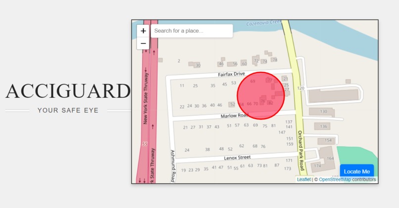
AcciGuard

AcciGuard is an interactive map application designed to enhance road safety by alerting users when they are near accident hotspots. This web-based tool allows users to visualize known accident-prone areas on a map and receive real-time alerts if they come within a certain proximity to these hazardous locations.
Features Interactive Map: Users can view accident hotspots marked with red transparent circles on an interactive map. Search Functionality: Users can search for specific locations and view them on the map. User Location Tracking: The application tracks the user's location and updates the map accordingly. Proximity Alerts: When a user is within 50 meters of a known accident hotspot, the application triggers an audio alert and a visual notification. Simulated Location for Testing: The application includes a simulated location feature to test proximity alerts easily.
How It Works Demo - https://youtu.be/sja4Um3P_Ew
Initialization The application starts by initializing a Leaflet map centered on a default location. The map uses OpenStreetMap tiles for rendering.
Displaying Hotspots Nine accident hotspots in NY State are pre-defined with their latitude and longitude coordinates. These hotspots are displayed on the map as red, semi-transparent circles with a radius of 50 meters. These circles visually indicate areas where accidents are more likely to occur.
Search Functionality The map includes a search box that allows users to search for specific locations using the Nominatim API. When a user types a location into the search box, the map fetches possible matching locations and displays them in a dropdown list. Selecting a location from this list centers the map on that location and adds a marker.
User Location Tracking The application has a "Locate Me" button that, when clicked, attempts to find the user's current location using the browser's geolocation API. Once the location is found, it places a marker at the user's location and checks the distance to each hotspot.
Proximity Alert The application continuously monitors the distance between the user's current location (or simulated location for testing) and the accident hotspots. If the user is detected within 50 meters of any hotspot, the application plays a beep sound and displays a warning message to alert the user of the potential danger.
Simulated Location for Testing To facilitate testing, the application includes a feature that simulates the user's location at one of the hotspots. This allows developers and users to test the proximity alert system without needing to physically visit the hotspot.
Built With
- api
- css3
- excel
- forward
- github
- html5
- java
- leaflet.js
- nomatin
- nominatim
- openstreetmap
- port
- python
- soundjay
- streamlit
- vscode

Log in or sign up for Devpost to join the conversation.