-
-
When the Waters Rise: A Story from Cité Soleil
Inspiration
Cité Soleil, a vibrant and bustling community, has endured countless challenges, but none more devastating than the floods that disrupt lives year after year. When the rains come, the streets transform into rivers, sweeping away homes, belongings, and hope. Marie, a mother of three, recalls the night the floodwaters breached her door. "We had nowhere to go," she says. "The water rose so fast, and all I could do was hold my children and pray."
What it does
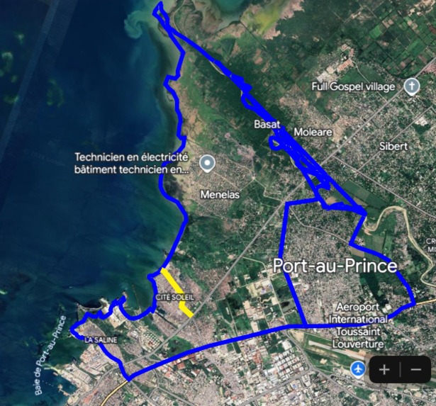
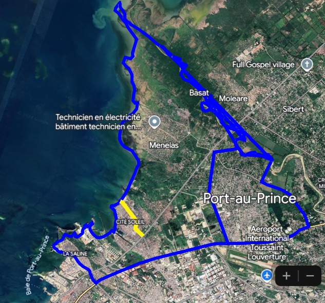
"Using My Photorealistic 3D Map to Tell Cité Soleil’s Story" I developed the web app using Google Maps to vividly illustrate the areas in Cité Soleil most vulnerable to flooding. Through this tool, I showcase the root causes—deforestation upstream and poor waste management—that intensify the risks.
But this app isn’t just about identifying problems; it tells the story of solutions in action. Funded by USAID and implemented by PADF, the program I feature on the map highlights impactful efforts like clearing debris from canals, planting trees upstream to stabilize the soil, and constructing dams to reduce waterway pressure.
By combining these elements into an engaging, interactive experience, my map bridges data and storytelling. It provides a powerful visual narrative that educates stakeholders, mobilizes local communities, and demonstrates the transformative impact of collective action. This tool makes it clear how our choices today shape a more resilient tomorrow for Cité Soleil.
How we built it
I built the web app using Notepad++ as my coding environment. The main programming language is JavaScript, which I used to integrate the Google Maps API for loading photorealistic 3D imagery. To represent areas of interest, I utilized GeoJSON to display polygons directly on the map. The app itself is structured in HTML, serving as the foundation for its interactive and visual storytelling capabilities. I use github to test and share
Challenges we ran into
As a GIS specialist, this was my first experience using the Google Maps API via JavaScript to create a full web app. Initially, understanding the API was a challenge. I spent the first two days familiarizing myself with its features and functions. However, the comprehensive Google Maps Platform guide proved invaluable, and after taking the time to dive into it, I became much more confident in navigating and utilizing the API effectively.
The second challenge was timing. I encountered this opportunity later than expected, which left me with limited time to develop the app. This required focused effort and quick adaptation to ensure I could submit the project on time. Despite these hurdles, the experience has been a rewarding learning journey.
Accomplishments that we're proud of
I’m proud of mastering the Google Maps API, a tool that was new to me at the start of this project. This experience has not only expanded my skill set but also shown me the potential to create impactful and meaningful applications with it.
What we learned
This project was a valuable learning experience. I deepened my understanding of the Google Maps API and how to integrate photorealistic 3D imagery and GeoJSON into a web app. I also learned the importance of patience and persistence when navigating new tools and platforms. Despite time constraints, I discovered how quickly I could adapt and deliver results by focusing on problem-solving and leveraging available resources like the Google Maps Platform guide.
What's next for A Journey Through Our Environmental Choices in Haiti
The next step is to expand the app’s functionality and reach. I plan to integrate real-time data to monitor environmental changes, such as rainfall patterns and flood risks, to provide actionable insights. Additionally, I aim to include community feedback and storytelling features, allowing residents to share their experiences and solutions.
Beyond improving the app, I want to collaborate with local organizations, schools, and policymakers to use this tool for education and advocacy. By demonstrating the impact of our choices and highlighting solutions, the app can inspire collective action to protect Haiti’s environment and build resilience.

Log in or sign up for Devpost to join the conversation.