Devpost
Participate in our public hackathons
Devpost for Teams
Access your company's private hackathons
Grow your developer ecosystem and promote your platform
Drive innovation, collaboration, and retention within your organization
By use case
Blog
Insights into hackathon planning and participation
Customer stories
Inspiration from peers and other industry leaders
Planning guides
Best practices for planning online and in-person hackathons
Webinars & events
Upcoming events and on-demand recordings
Help desk
Common questions and support documentation
Low Cost Airborne UAV carrying a ESP32-EYE. It flies Low and SLow. Captures Road and Terrain Data, Georeferences the Photographs and Adds to Google part of AutoGIS Ecosystem. #1/3
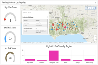
GIS platform in predicting infestations.
A high-level application that enables automatic mapping of image data from Mediavalet to survey data from Survey123, with added functionalities for multi-level e-Signatures powered by Docusign.