-
-

World’s first AI-driven geospatial data modeling recommender
-

GeoOrgan - A logo made to showcase the amazing partnership
-


🌍✨ Inspiration ✨🌍
GeoOrgan AI was born from a deeply personal and heart-wrenching experience 💔. Years ago, I lost a beloved family member who was waiting for an organ transplant 🏥. Although the organ was available, due to critical logistical failures—such as delays in transport 🚚, lack of real-time tracking 📡, and poor route optimization 🗺️—the organ never arrived in time ⏳. This devastating loss revealed a glaring and urgent gap: even as technology advances at lightning speed ⚡, life-saving logistics often lag behind, especially when it comes to geospatial intelligence 🌐. As a developer 👨💻, I realized that despite the existence of powerful tools, most engineers struggle with modeling, storing, and querying geospatial data 🗄️, because guidance is fragmented and the learning curve is steep 📈, which means that impactful use cases—like organ transport 🚑, disaster relief 🌪️, or smart city logistics 🏙️—remain largely unexplored and underdeveloped. GeoOrgan AI is my answer to this critical problem—a blueprint and a call to action 📢 to empower every developer to build geospatial solutions that truly matter ❤️. By combining real organ transport data 📊, AI-driven recommendations 🤖, and the best of Google Cloud ☁️ and MongoDB 🍃, GeoOrgan AI aims to make geospatial modeling accessible, actionable, and impactful for all developers, everywhere 🌍.
Access the full GeoOrgan AI project and all related resources here:
GitHub Repository:
GeoOrgan AI on GitLab
Direct URL:
https://gitlab.com/hello2arvind/GeoOrgan
🚀 What it does 🚀
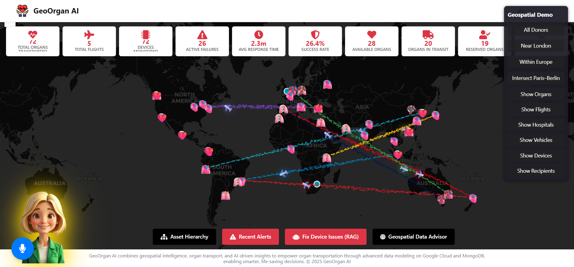
GeoOrgan AI is the world’s first open-source, AI-driven geospatial data modeling recommender and logistics platform 🏆, purpose-built for organ transport 🚑 but fully extensible to any domain 🌐. Here’s what it offers:
- 🗺️ Geospatial Modeling Advisor: Using Retrieval-Augmented Generation (RAG), Google ADK, and Gemini LLM, GeoOrgan AI provides step-by-step, context-aware guidance for modeling, indexing, and querying geospatial data in MongoDB 🧠.
- 📍 Real-Time Organ Transport Dashboard: Visualizes live organ donation and transport data on interactive maps 🗺️, optimizing routes and highlighting potential delays 🚦.
- 🗣️ AI Voice & Chat Assistant “Klaudia”: Answers questions, explains best practices, and helps users interact with data using natural language and voice commands 🎤.
- 📚 Best Practices Engine: Delivers actionable schema, index, and query recommendations tailored specifically to your data and use case 🎯.
- ☁️ Cloud-Native & Modular: Built on Google Cloud and MongoDB Atlas, it’s scalable, secure 🔒, and easy to extend for any geospatial or AI application 🔧.
🛠️ How we built it 🛠️
GeoOrgan AI is a full-stack, cloud-native platform built with modern, open-source technologies:
- Backend: Flask (Python) orchestrates all API routes, connects to MongoDB Atlas, and integrates with Google Gemini/ADK (LLM/RAG) and Google’s Multimodal API for voice interaction 🐍.
- Database: MongoDB Atlas stores geospatial, vector, and tabular data, with 2dsphere and vector indexes powering advanced queries and recommendations 🗄️.
- Frontend: Bootstrap and Google Maps provide a responsive, real-time dashboard with animated maps, advisor panels, and alerting 🎨.
- AI Layer: Gemini LLM powers Retrieval-Augmented Generation, delivering context-aware modeling advice and recommendations 🤖.
- Voice Assistant: Multimodal API enables full-duplex speech-to-text, letting users interact with the platform naturally and intuitively 🗣️.
- Data Pipelines: Real-world datasets (organ donors, flights ✈️, cities 🏙️, weather ☀️🌧️) are ingested and modeled, demonstrating best practices.
- Extensibility: Modular codebase allows easy addition of new data sources, RAG collections, and cloud integrations 🔌.
⚠️ Challenges we ran into ⚠️
Building GeoOrgan AI was as challenging as it was rewarding:
- Complex Geospatial Modeling: Translating real-world organ transport logistics into actionable, queryable geospatial models in MongoDB required deep research and experimentation 🔍. Starting from learning MongoDB fundamentals to building the full use case was both fun and challenging 🎢.
- RAG Integration: Making Gemini LLM deliver precise, context-aware modeling advice grounded in real data and best practices was a significant technical hurdle 🧩.
- Voice UX: Ensuring the voice assistant was not just functional but truly helpful and context-aware took extensive iteration and testing 🎙️. The Multimodal API was complex to integrate and implement.
- Data Quality & Privacy: Sourcing real, anonymized organ transport data and ensuring compliance with strict privacy standards was essential 🔐. We had to clean, polish, and scrub large datasets meticulously 🧼.
- Developer Accessibility: Striking the right balance between advanced features and a simple, intuitive UX was a constant focus 🎯.
- Performance at Scale: Ensuring real-time analytics and recommendations remained fast and reliable, even with large datasets, required careful optimization and engineering excellence ⚙️.
🏆 Accomplishments that we're proud of 🏆
- First-of-its-Kind Platform: GeoOrgan AI is the only open-source, RAG-powered geospatial modeling advisor for MongoDB and Google Cloud 🌟.
- Real Impact: By using real organ transport data, we’re not just theorizing—we’re showing how to save lives with better data modeling ❤️.
- Developer Empowerment: We’ve made complex geospatial modeling understandable and actionable for any developer, anywhere 🌍.
- Seamless Integration: The combination of Gemini LLM, MongoDB Atlas, and Google Cloud is smooth, scalable, and production-ready 🚀.
- Open Source: Designed for sharing and rapid adoption, GeoOrgan AI is a gift 🎁 to the global developer community.
- Beautiful, Accessible UX: The dashboard is modern, responsive, and accessible, with a consistent, memorable brand identity 🎨.
📚 What we learned 📚
- The Power of Real Use Cases: Nothing motivates or educates like a life-critical, real-world problem. Organ transport logistics is a compelling, high-impact scenario that resonates with developers and non-developers alike ❤️.
- Geospatial is Hard—But Solvable: With the right tools and guidance, even complex geospatial modeling can be made accessible to all 🛠️.
- AI + Data = Actionable Insights: RAG-powered recommendations are a game changer for developer productivity and learning 🤖.
- Voice Matters: Natural, conversational interfaces lower barriers and make advanced tools more approachable 🗣️.
- Open Source Accelerates Impact: Sharing knowledge and code multiplies the potential for innovation and real-world change 🌐.
🔮 What's next for the world’s first AI-driven geospatial data modeling recommender 🔮
GeoOrgan AI is just the beginning. Here’s what’s next:
- Broader Use Cases: Extend to other life-critical domains—disaster response 🌪️, emergency logistics 🚨, smart cities 🏙️, environmental monitoring 🌿, and more.
- Community Contributions: Open the platform to contributors worldwide 🌎, growing a vibrant ecosystem of geospatial data modeling guides, datasets, and AI-powered tools 🤝.
- Deeper AI Integration: Enhance RAG and Gemini LLM capabilities for even richer, more nuanced recommendations 🧠.
- Mobile & Edge: Bring real-time geospatial intelligence to mobile and edge devices for field teams and remote operations 📱.
- Partnerships: Collaborate with health organizations 🏥, logistics companies 🚚, and governments 🏛️ to deploy GeoOrgan AI in real-world scenarios.
- Education: Launch workshops, tutorials, and hackathons 💻 to teach developers how to build impactful geospatial solutions.
- Continuous Improvement: Iterate on feedback, add new features, and keep pushing the boundaries of what’s possible with geospatial AI 🚀.
GeoOrgan AI is more than a project—it’s a mission 🌟. By empowering developers with the tools, guidance, and inspiration to tackle real-world, high-impact problems, we can save lives ❤️, transform industries 🌍, and build a smarter, more compassionate world 🤝. Let’s build the future of geospatial intelligence—together! 🚀


Log in or sign up for Devpost to join the conversation.