-
-

WildSat logo
-

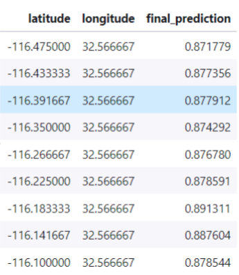
Pipeline block diagram
-

CO/CO2 values
-

Real measured temperatures
-

Predicted temperatures


Inspiration
Natural disasters are happening unexpectedly and affecting thousands or millions of people's life. Earthquakes, cyclones, wildfires are some of them. Fortunately, scientists are constantly either looking for ways to make new techniques or improve already found ones to overcome the difficulties of all those disasters make. There are some approaches, products that employ AI or machine learning, in general, to predict the next disaster's occurrence. In the case of wildfire, things are more difficult. Weather temperature, humidity, pressure, wind speed, wind direction, rurality, the vegetation of the area, and much more affect wildfire and its severity. Each year wildfire costs a total of between 3 and 5 billion $ (USD) in the USA alone. Also burned fuels emit greenhouse gases that increase the severity of climate change.
What it does
WildSat employs machine learning algorithms to detect wildfires by just only using data from satellites. Designed pipeline assures fast, cost-effective, reliable predictions. WildSat consists of 3 machine learning models. In terms of architecture, 2 models are exactly the same and use ensemble techniques to provide results. Those models simulate temperature, CO/CO2 emission for date/time and location provided. On the other hand, a u-net-based convolutional neural network is trained just to detect fire regions. The outputs of the 2 models compared with real satellite data,combined with shortwave radiation measurements abnormalities pin-pointed to probability map. In the final phase, u-net based model checks those areas if a wildfire is found then segmented areas, coordinates, etc sent to responsible units as slack or SMS reports. Probability map makes wildfire detection more accurate, fast, and cost-effective.
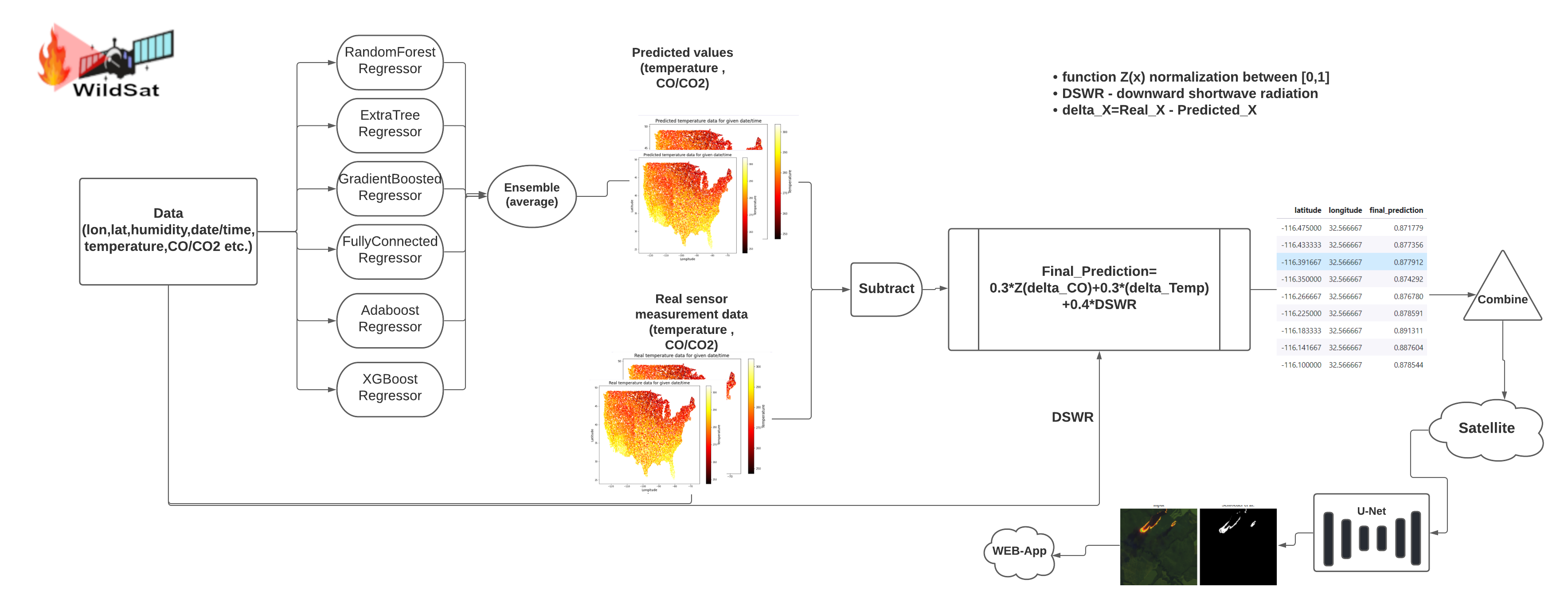
Probability map :
How we built it
For the demo, I prepared a simple web-app that takes inputs via upload or API response (in perfect case it takes data directly from satellite ). In terms of proof of concept (POC) this API sends only wildfire emerged area's footage. I used NumPy,OpenCV,PyTorch,torchvision,sci-kit-learn,flask,pandas,twilio API etc. for this project. All the training and PoC are done in Amazon SageMaker studio labs.
Challenges we ran into
Search for the dataset that would be useful for this project was time-consuming and cleaning, polishing, dealing with overfitted networks were the main challenges that I run into. Also checked scientific materials, literature I thought would be useful and to make my project more scientifically accurate while constantly improving the project.
Accomplishments that we're proud of
I was able to work on my idea which solves real-life issue improved it over time and served as proof of concept. Simple web application programming, data preparation, neural network training, scientific literature reading are some of them that are completed just in time.
What we learned
After many hours of work, I would say I learned a lot on the way. How to work with Amazon Sagemaker, dealing with the extremely overfitted network, troubleshooting, are some of them. Also, I learned to be much more responsible for our environment and the possible consequences of our actions.
What's next for WildSat :
We were only able to scratch the surface of what's possible for this project with more training and data from satellite I believe this project will help many lives and our planet in general.
Datasets used :
*** Unfortunately I could not find exact dataset that I was initially looking for so I have chose the most closest ones.
- GridMet datset
- EPA CO daily summary
- Active fire detection in Landsat-8 imagery: A large-scale dataset and a deep-learning study (Gabriel Henrique {de Almeida Pereira} and Andre Minoro Fusioka and Bogdan Tomoyuki Nassu and Rodrigo Minetto)
- Info about downward surface shortwave radiation


Log in or sign up for Devpost to join the conversation.