-
-
Overview
Inspiration
Human–wildlife conflict is a growing challenge for both communities and wildlife. When forests become fragmented and natural habitats increasingly overlap with agricultural land, roads, and settlements, the chances of conflict can increase.
We wanted to build something that goes beyond showing historical wildlife-conflict incidents. Our goal was to create a system that could help answer three practical questions:
Where is conflict risk high? Why is it high? And what can be done to reduce that risk?
This led us to build WildGuard AI, an AI-powered geospatial decision-support system focused initially on human–elephant conflict.
Our motivation was to use machine learning not just to make predictions, but to turn environmental data into information that can support wildlife conservation and preventive action.
What it does
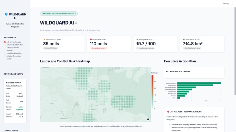
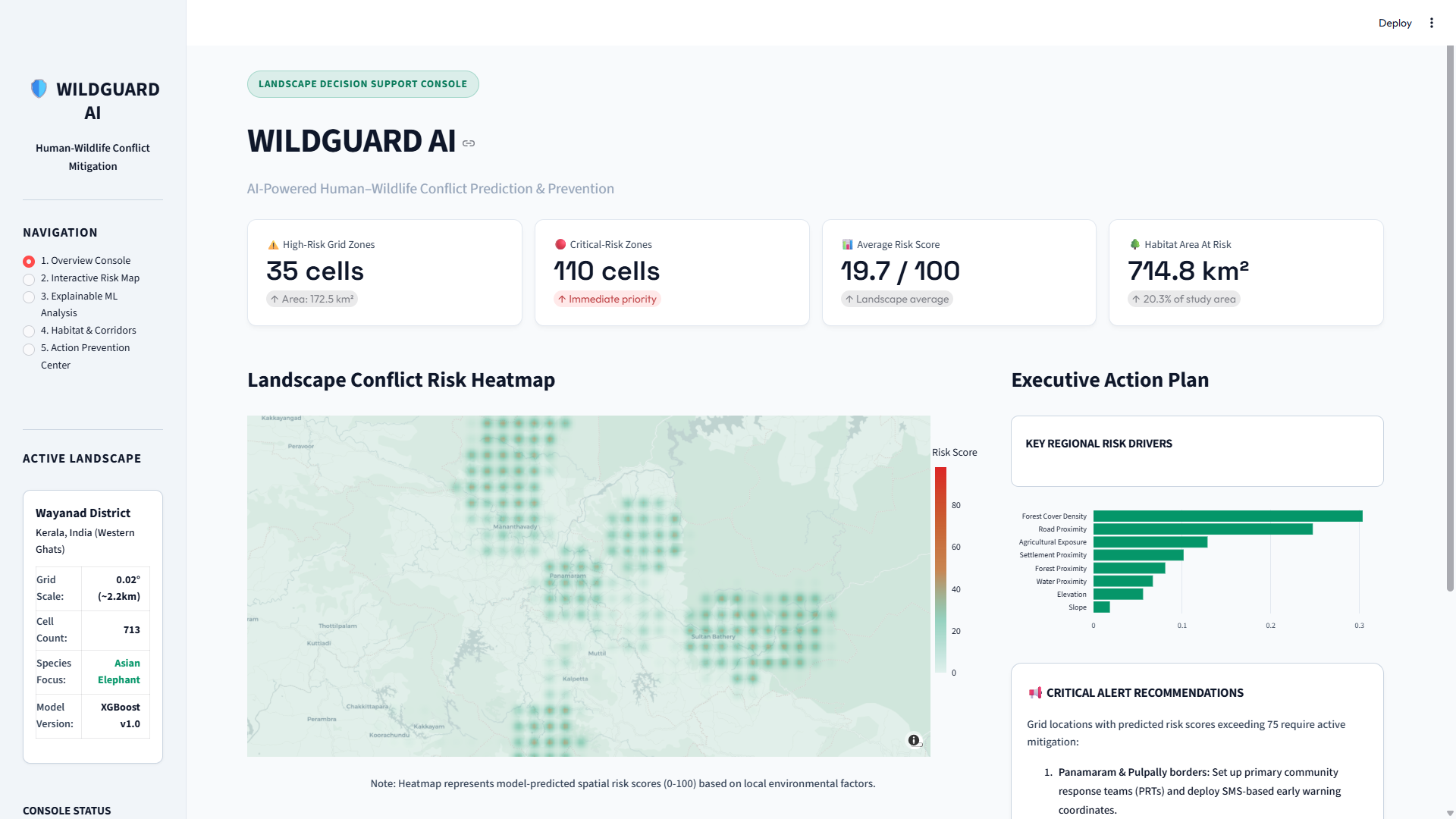
WildGuard AI estimates the spatial risk of human–elephant conflict using historical conflict patterns and environmental/geospatial factors.
The platform provides:
- 🗺️ Interactive Conflict Risk Map — visualizes predicted risk across geographic areas.
- 🤖 ML-Based Risk Prediction — estimates conflict risk using environmental and geographic features.
- 🔎 Explainable AI — uses SHAP to show the factors contributing to a prediction.
- 🌳 Habitat Analysis — examines environmental conditions associated with habitat pressure and fragmentation.
- 🛡️ Prevention Recommendations — converts identified risk factors into practical conservation actions.
- 🐘 Potential Habitat Connectivity Analysis — highlights areas that may deserve further assessment for habitat connectivity.
The core idea is:
Predict → Explain → Prevent → Protect
WildGuard does not attempt to predict the exact movement of an individual elephant. Instead, it estimates spatial conflict risk based on patterns present in the available data.
How we built it
We built WildGuard AI as a geospatial machine-learning application using Python.
The overall pipeline is:
Environmental & Conflict Data
            ↓
      Data Processing
            ↓
    Geospatial Features
            ↓
       ML Prediction
            ↓
     Spatial Risk Score
            ↓
      SHAP Explainability
            ↓
 Prevention Recommendations
            ↓
     Interactive Dashboard
Machine Learning
We use XGBoost as the primary machine-learning model for spatial risk prediction, with baseline models used for comparison.
Features can include environmental and geographic factors such as:
- Historical conflict patterns
- Forest cover and fragmentation
- Agricultural land
- Distance to settlements
- Distance to roads
- Distance to water bodies
- Other available geographic/environmental variables
Explainable AI
We use SHAP to understand the contribution of individual features to model predictions.
This allows WildGuard to provide not only a risk score but also an explanation of the major factors associated with that risk.
Geospatial Analysis
We use geospatial processing to transform environmental datasets into features that can be associated with geographic areas.
The results are displayed through an interactive map so users can explore different risk zones.
Application
The application is built with Streamlit, with tools such as Pandas, GeoPandas, XGBoost, SHAP, Plotly, and Folium used across the data, machine-learning, visualization, and geospatial pipeline.
Challenges we ran into
Integrating different datasets
Environmental datasets often come from different sources and have different geographic and temporal resolutions.
Combining these datasets into a consistent spatial representation required careful preprocessing and feature engineering.
Building a meaningful prediction target
Human–wildlife conflict is complex and influenced by many factors. We had to avoid creating an arbitrary risk score and instead design the prediction target around the actual conflict information available in the data.
Spatial data leakage
Nearby geographic locations can have very similar environmental characteristics. A conventional random train/test split can therefore produce overly optimistic results.
We had to consider spatial relationships when evaluating the model.
Making predictions understandable
A model output such as "high risk" is not very useful by itself.
We therefore incorporated SHAP-based explanations so users can understand which factors are contributing most strongly to a prediction.
Balancing ambition and feasibility
We initially considered building a much broader wildlife platform. However, with limited development time, we focused the MVP on human–elephant conflict and prioritized the features that provide the most environmental value.
Accomplishments that we're proud of
We are proud that WildGuard AI brings together several components into a single environmental decision-support system:
- A real-world environmental problem
- Machine-learning-based spatial risk prediction
- Interactive geospatial visualization
- Explainable AI using SHAP
- Habitat and connectivity analysis
- Prevention-oriented recommendations
- A user-friendly web interface
Most importantly, we designed WildGuard around action rather than prediction alone.
Instead of simply saying:
"This area has high risk."
WildGuard attempts to explain:
"This area has elevated risk because of these environmental factors, and these areas may deserve priority for preventive action."
That makes the system more useful as a conservation-planning tool.
What we learned
We learned that building environmental AI is not only about selecting a powerful machine-learning algorithm.
The hardest and most important part is connecting data to a real-world decision.
During development, we learned about:
- Geospatial data processing
- Spatial feature engineering
- Environmental risk modeling
- Explainable machine learning
- Spatial model evaluation
- Interactive map visualization
- Data integration
- Communicating model uncertainty
- Designing AI systems for real-world users
We also learned the importance of being careful with environmental predictions. A model can identify patterns in historical data, but it cannot replace field observations, local ecological knowledge, or expert judgment.
What's next for WildGuard AI
WildGuard AI is currently focused on human–elephant conflict, but the platform can be expanded into a broader wildlife-conservation intelligence system.
Future improvements include:
- 🐅 Support for additional wildlife species
- 📡 Near-real-time environmental data
- 🛰️ Satellite-based habitat monitoring
- 📷 Camera-trap integration
- 🎧 Acoustic wildlife monitoring
- 🛣️ More advanced habitat-connectivity analysis
- 📱 Mobile alerts for conservation teams
- 👥 Community-based conflict reporting
- 🌍 Expansion to additional geographic regions
- 🔄 Continuous model improvement with new field data
Our long-term vision is to build a system that helps conservation teams move from reactive conflict management toward proactive wildlife and habitat protection.
WildGuard AI — Predict. Explain. Prevent. Protect.
Built With
- analysis
- artificial
- data
- environmental-conservation
- folium
- geopandas
- geospatial
- intelligence
- learning
- machine
- numpy
- pandas
- plotly
- python
- scikit-learn
- shap
- streamlit
- visualization
- xgboost

Log in or sign up for Devpost to join the conversation.