-
-
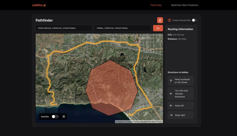
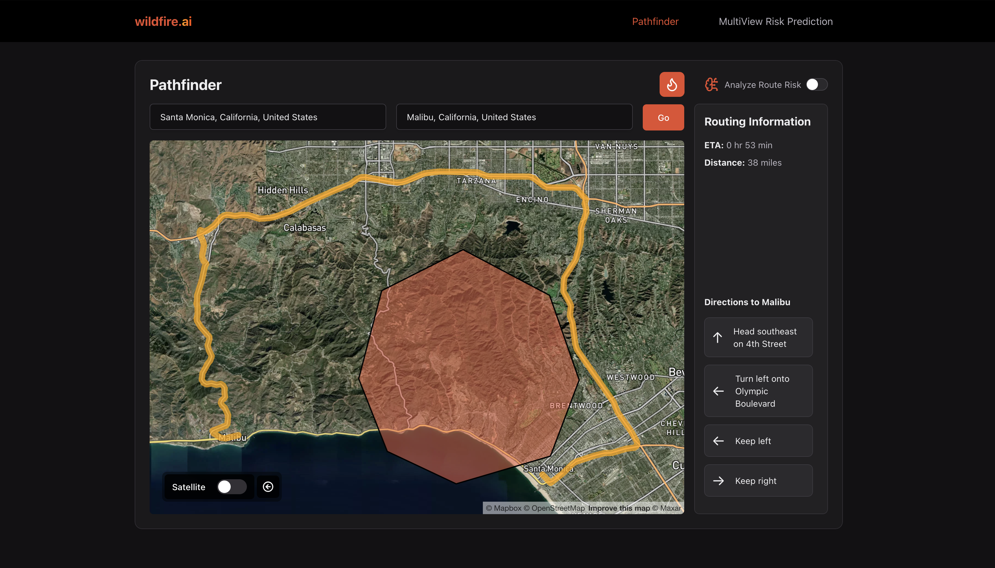
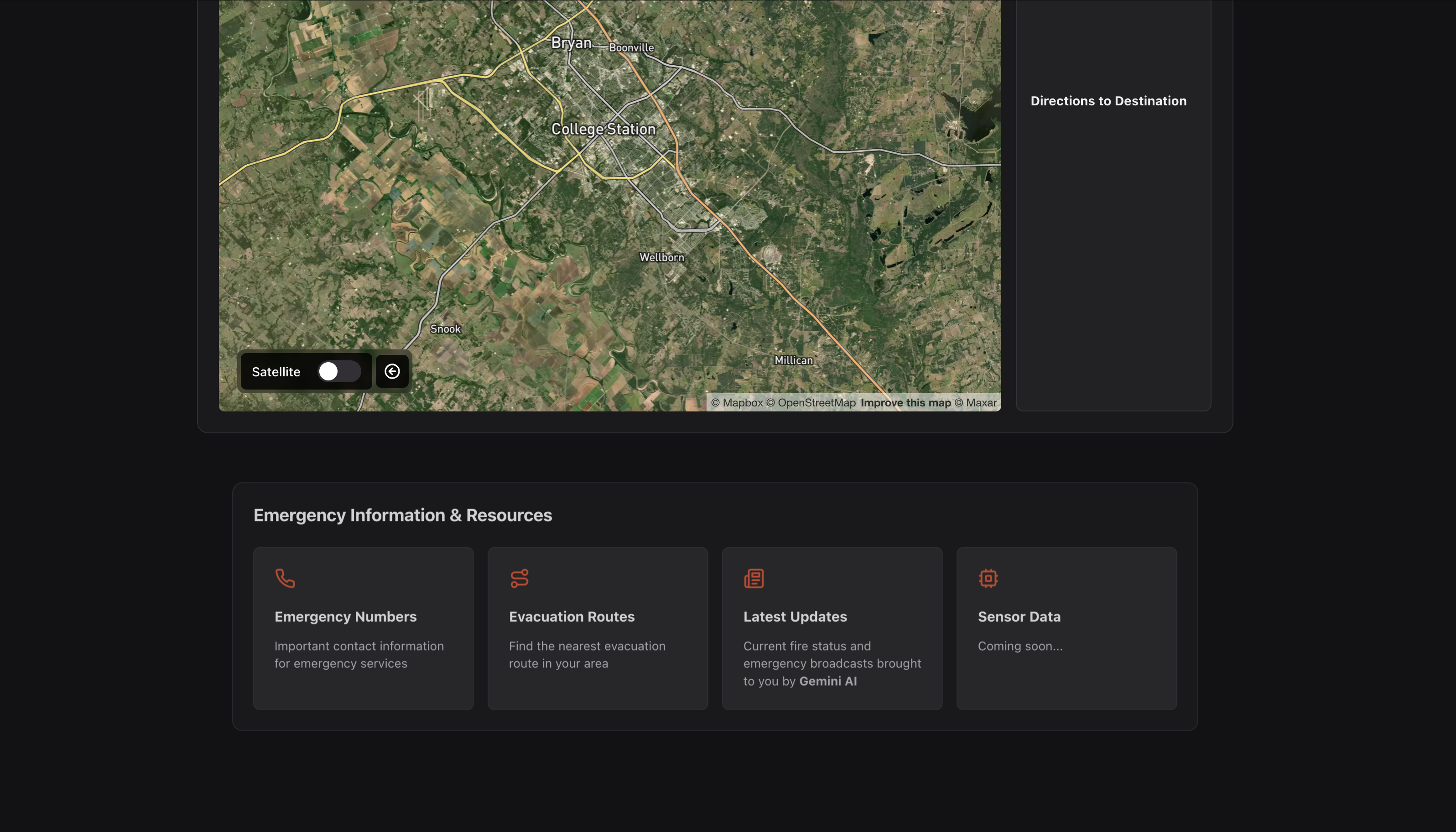
Routing around wildfires
-
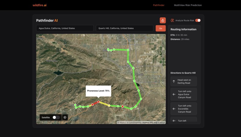
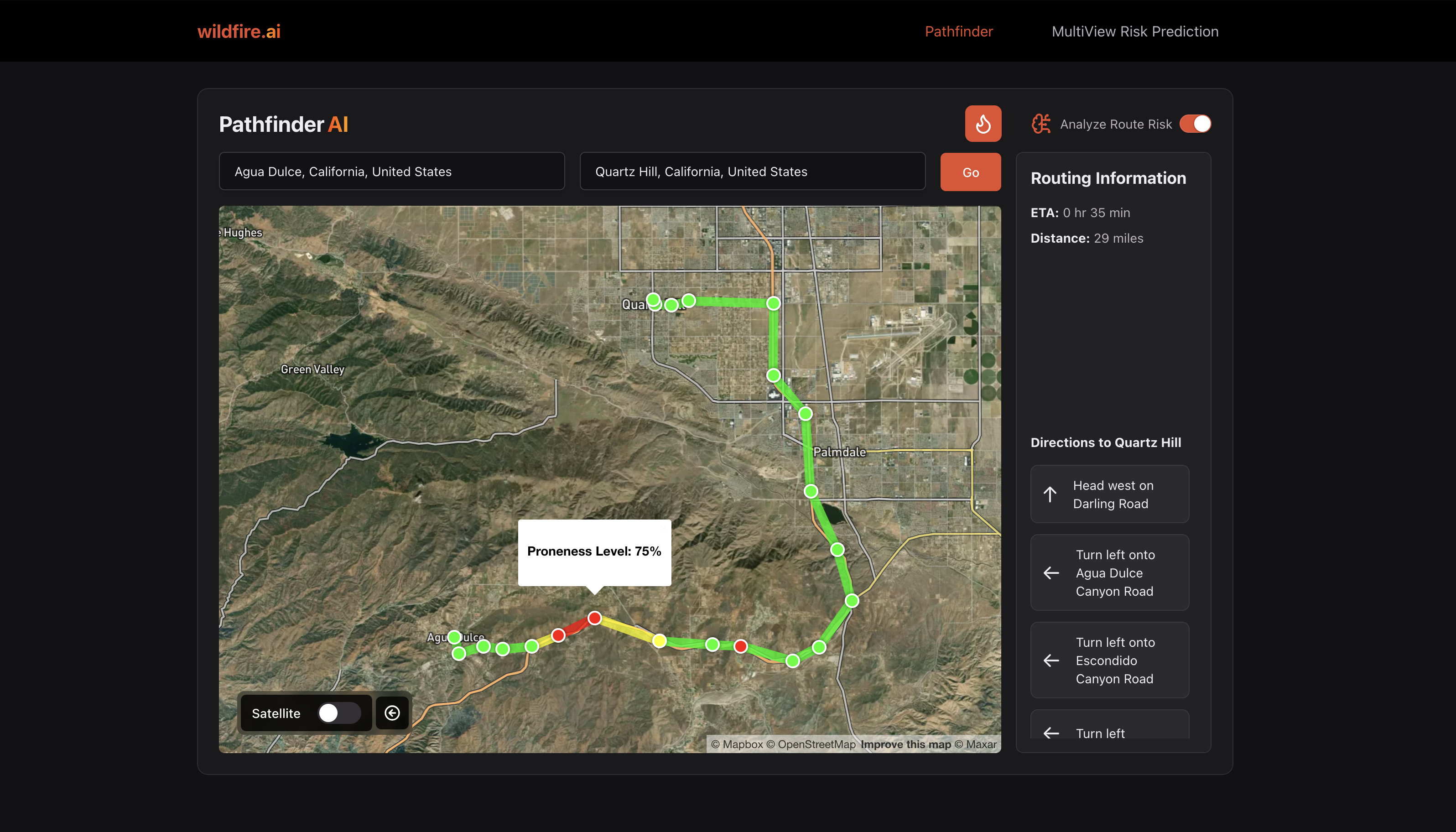
Route safety prediction analysis based on CNN
-
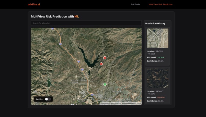
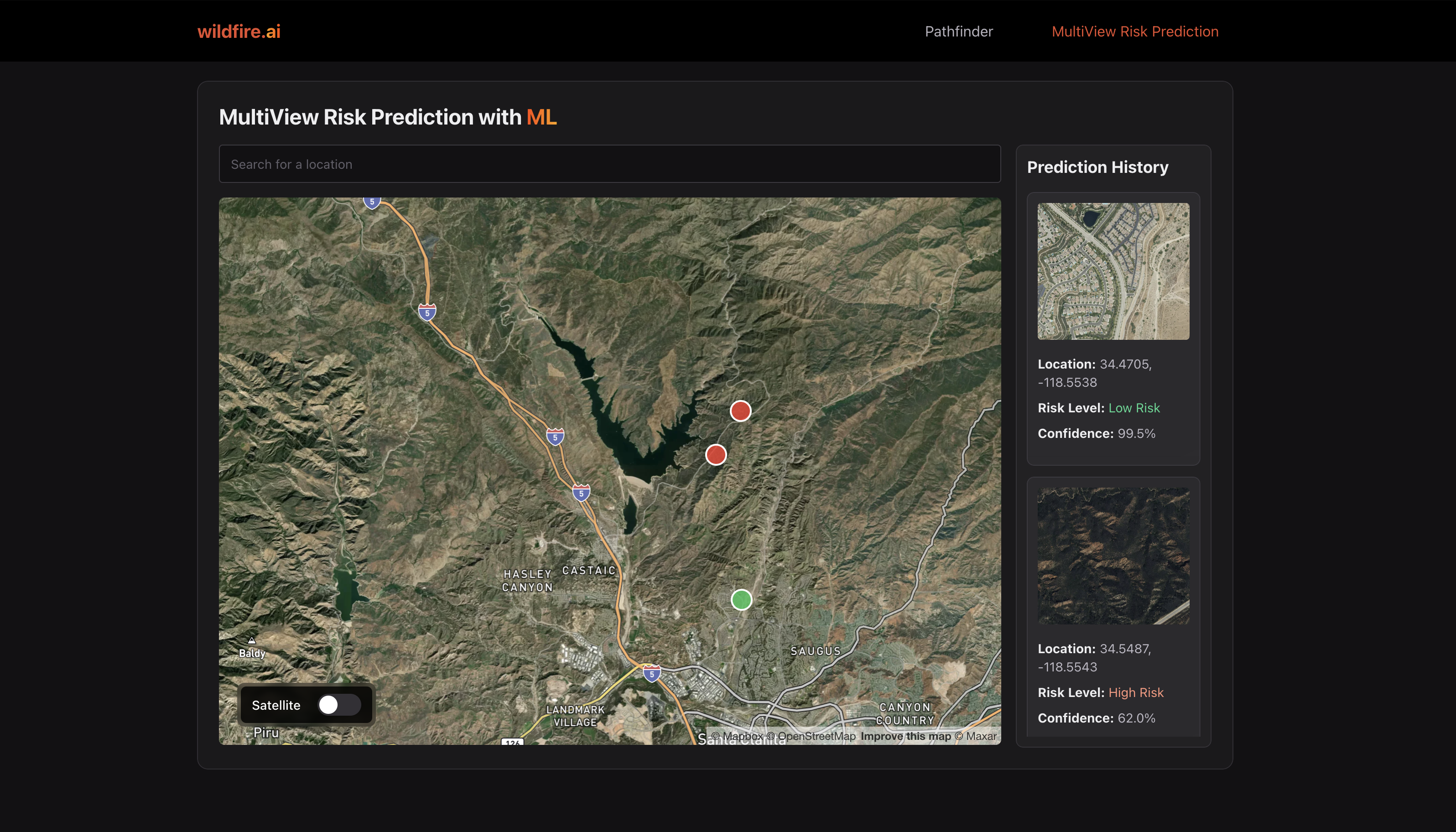
Location based wildfire risk prediction
-
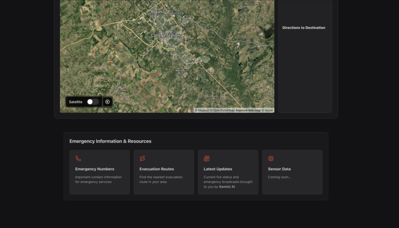
Wildfire emergency resources and news
-
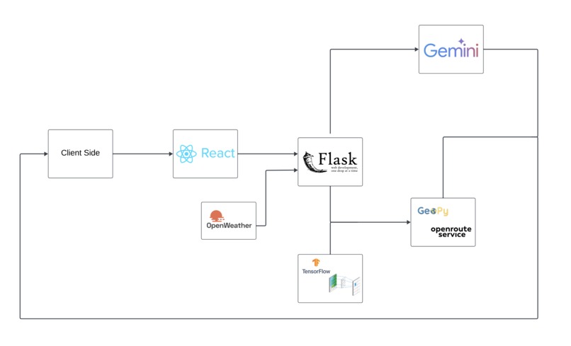
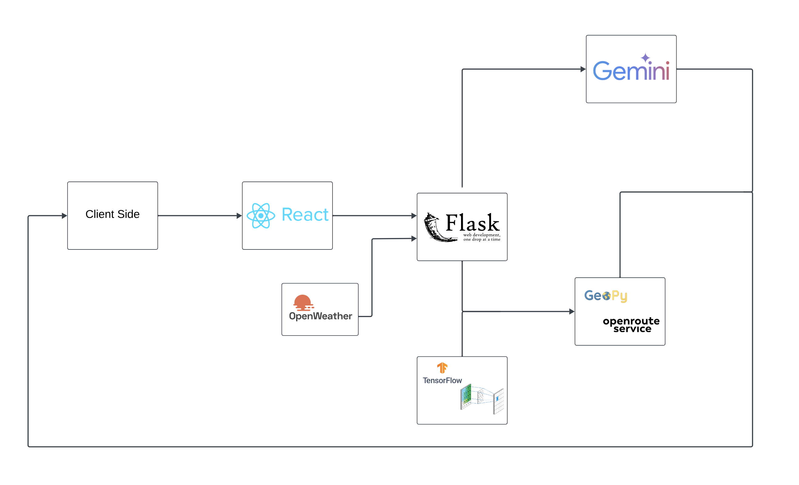
Tech Stack
Inspiration
Recent events, such as the devastating California wildfires, have highlighted the urgency of proactive measures to combat these disasters. In the summer of 2023, wildfires swept across California, causing billions of dollars in damages, displacing thousands of residents, and destroying critical ecosystems. The fires were fueled by extreme weather conditions, including record-breaking heat and prolonged droughts, which underscore the importance of early detection and risk management. This inspired us to create a solution that leverages advanced technology, including machine learning, real-time weather data, and satellite imagery, to predict wildfire risks and enable communities to act before a disaster strikes. By focusing on early detection, risk assessment, and evacuation planning, we aim to empower individuals, emergency responders, and entire communities with the tools needed to mitigate the impact of wildfires and safeguard lives, property, and our environment.
What it does
wildfire.ai is an AI-powered wildfire monitoring system that has 2 main features:
- Finding safe and efficient paths for users evacuating from wildfires
- Predicting the risk of wildfires in the future in user-defined locations/routes
Using satellite imagery, machine learning, and real-time weather data, we provide accurate risk assessments and evacuation planning for communities in fire-prone areas.
Our set of technologies includes a TensorFlow-based prediction model that analyzes satellite imagery to detect fire risks, while Google's Gemini AI provides real-time local updates and emergency resources. Our interactive map interface lets users input their locations/destinations and receive safe evacuation routes that automatically avoid active/possible fire zones.
We've built this during TAMUHack 2025 to address a critical need: in 2024 alone, wildfires caused over $13 billion in damages. wildfire.ai empowers communities and emergency responders with the information they need, when they need it, potentially saving countless lives and properties.
Our wildfire risk prediction component maintains a list of previous ML predictions, each showing satellite imagery, risk levels, and confidence scores. We also implemented address search functionality, focused primarily on performance optimization, and ensured a smooth user experience across different devices. The result is a comprehensive system that combines multiple APIs and data sources into a unified interface for wildfire risk management and emergency response.
How we built it
We developed wildfire.ai as a full-stack web application that combines machine learning, real-time data, and interactive mapping to help communities monitor and respond to wildfire risks.
The frontend is built with React and Vite, featuring a central interactive map component that uses Mapbox GL for visualization. Combining the official California wildfire API and openroute service APIs, we developed custom routing/directions for users to their destinations.
Users can click anywhere on the map to analyze wildfire risk, with color-coded markers indicating risk levels - red for high risk and green for low risk. The backend is powered by Flask and handles multiple data streams.
We also used a Convolutional Neural Network (CNN) built with TensorFlow for analysis of satellite imagery to predict fire risks with this Kaggle dataset. We made this choice to try and capture patterns such as vegetation density, land use, and topographical features that affect wildfire risks. We also integrated Google's Gemini AI to provide real-time updates about local fire conditions and emergency resources.
By combining advanced ML-driven insights, real-time situational data, and an engaging user experience, wildfire.ai offers a cutting-edge solution for safeguarding lives, property, and the environment against the growing threat of wildfires.
Challenges we ran into
One of our biggest technical challenges was integrating real-time fire perimeter data with evacuation routing. We solved this by implementing a clustered polygon-based fire zone mapping system to restrict possible "danger areas" that we were able to determine with our model. This polygon system then communicates with OpenRouteService to generate safe evacuation routes avoiding active fire areas.
Accomplishments that we're proud of
One of our proudest achievements with wildfire.ai was creating a simple, easy-to-use system that hides its complex technology behind an intuitive interface. When users open our app, they don't see the sophisticated machine learning or AI systems running in the background – they just see a clear, interactive map where they can click anywhere to understand wildfire risks in their area. Whether someone is checking if their neighborhood is at risk, planning a safe evacuation route, or looking for nearby emergency resources, everything works smoothly and naturally.
What we learned
This project required navigating and integrating an abundance of data and APIs to achieve its full potential. From satellite imagery and weather data to emergency resources and routing services, we leveraged multiple APIs like OpenWeatherMap, Mapbox, and Google Gemini AI. Managing and synthesizing these diverse data streams was a critical challenge, teaching us the importance of efficient API handling, data normalization, and backend optimization to build a robust backend and ensure a seamless and accurate user experience.
Training the CNN proved to be a difficult task, but finding high-quality data was quite easy with the Mapbox API. Experimenting with the parameters and layers was very beneficial to our understanding of ML.
What's next for wildfire.ai
- To transform our product into a mobile app and integrate features like push notifications and location-based alerts to proactively warn users about potential wildfire threats.
- Expand our database of wildfires globally to reach more users.
- Improve our risk prediction algorithm to take into account factors like wind speed, direction, air quality, proximity to active fires, etc.


Log in or sign up for Devpost to join the conversation.