-
-
Project icon
-

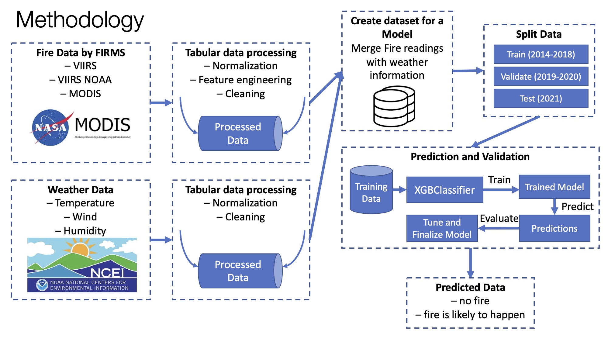
Project scheme
-

Wildfire Prediction
Inspiration
Wildfires are a serious problem that threatens lives, communities, wildlife, and forests every year. They are a global issue and are considered one of the most dangerous disasters we face.
According to the facts of the Insurance Information Institute, as many as 90 percent of wildland fires in the United States are caused by people, according to the U.S. Department of Interior. Some human-caused fires result from campfires left unattended, the burning of debris, downed power lines, negligently discarded cigarettes, and intentional acts of arson. The remaining 10 percent are started by lightning or lava.
While humans cause many fires, other factors, including wind, lightning, drought, and landscape, impact where fires occur and how they spread.
According to Verisk’s 2019 Wildfire Risk Analysis 4.5 million U.S. homes were identified at high or extreme risk of wildfire. According to the latest Verisk estimates, in California, there were more than 2 million properties at high to extreme wildfire risk in 2021, the largest number of properties of any U.S. state.
Australia is another country that had suffered from wildfires significantly. According to statistics (statista.com), the Australian 2019/2020 bushfire season was one of the worst in recent times in the world. The season started in early November 2019 in New South Wales, and gradually progressed in Victoria, Western Australia, South Australia, and the Australian Capital Territory. Thousands of firefighters and volunteers battled the fires, with millions of hectares burned, thousands of properties damaged, and countless numbers of wildlife exposed.
Wildfires present unique and severe forecasting challenges.
What it does
My goal is to provide first responders, Firefighters, and Firefighting Command Centers, with a new AI app that can be used to help save lives and property. This application will be responsible for predicting the behavior of the wildfires.
How we built it
It's not always possible to predict the precise trigger or spark for a wildfire event, but wildfire risk can be estimated to some extent by understanding how climate, topography, weather, and land cover impact fire behavior and the likelihood of a fire spreading.
I conducted data analysis of the wildfire domain, explored available data sources, designed and developed a machine learning prediction model that focused on forecasting wildfire spread and occurrence. This model relies on publicly available datasets.
FIRMS distributes Near Real-Time (NRT) active fire data within 3 hours of satellite observation from the Moderate Resolution Imaging Spectroradiometer (MODIS) aboard the Aqua and Terra satellites, and the Visible Infrared Imaging Radiometer Suite (VIIRS) aboard S-NPP and NOAA 20.
The archive fire datasets can be found at https://firms.modaps.eosdis.nasa.gov/download/ in yearly chunks for each instrument.
• MODIS Collection 6.1: Temporal Coverage: 11 November 2000 - present • VIIRS S-NPP 375m: Temporal Coverage: 20 January 2012 - present • VIIRS NOAA-20 375m: Temporal Coverage: 1 January 2020 - present
Challenges we ran into
The first difficulty raised in the beginning is related to dataset selection. It is hard to find datasets that will accurately reflect the data that models see in the real world. Different datasets cover different periods that should be addressed in some way.
The other challenge is related to the problem of big data processing. Datasets presenting historical datasets are usually huge and require high-performance hardware. Therefore, relevant data science techniques and algorithms are required to process such types of data.
Accomplishments that we're proud of
I managed to build a machine learning model that is responsible for automatic wildfire prediction for areas of interest. Although the model is focused on predicting fire in Australia, it can be easily adapted for use in many other different countries that suffer wildfires from year to year.
What we learned
Wildfires, whether natural or caused by humans, are considered among the most dangerous and devastating disasters around the world. Their complexity comes from the fact that they are hard to predict, hard to extinguish, and cause enormous financial losses. Nevertheless, to address this issue, monitoring, prediction, and prevention wildfires using Artificial Intelligence techniques and strategies such as Big Data, Machine Learning, and Remote Sensing, demonstrated showed results of a high level. It is a great achievement to prevent wildfires by predicting fire occurrence, and therefore, increase safety for people and wildlife.


Log in or sign up for Devpost to join the conversation.