-
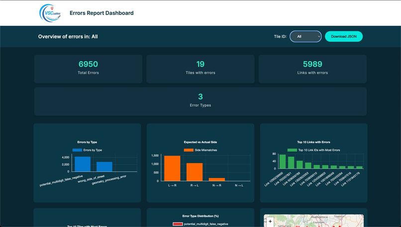
Dashboard with results

💡 Inspiration
Mapping megacities like Mexico City is incredibly complex. Map quality assurance (QA) still depends heavily on manual review, which is slow and prone to errors. We built VSCuates to automate QA of digital maps using data from HERE’s NavStreets dataset—helping detect common mapping issues quickly and at scale.
🚦 What it does
VSCuates is a geospatial QA engine that runs four specialized validation modules on urban map data:
Side-of-Street Detection Checks if a POI (Point of Interest) is correctly placed on the left or right side of a street.
MULTIDIGIT Verification Verifies if roads marked as "Multiply Digitised" truly meet geometric and direction criteria.
Existence & Legal Exceptions Confirms whether a POI address is valid—taking into account special cases like pedestrian-only zones or truck access.
Invalid Link Detection Flags POIs with missing or malformed road segment references (
link_id), or broken geometries.
Each module exports clean, structured JSON reports with suggestions and metadata—ready for QA teams to review.
🧱 How we built it
- Python, GeoPandas, and Shapely for spatial logic and geometry operations.
- A modular pipeline that processes each tile independently for better scalability.
- Custom vector math using cross products to detect POI orientation and position.
- Address range validation using the STREETS_NAMING_ADDRESSING layer.
- Legal exception logic based on access types (pedestrian, truck, bus, etc.).
🧩 Challenges we ran into
- Understanding HERE's direction conventions (e.g.,
DIR_TRAVEL = F, T, B) and normalizing them across datasets. - Translating ambiguous documentation into reproducible, logic-based rules.
- Ensuring sub-meter accuracy when calculating distances and address ranges.
- Handling edge cases with missing or malformed data.
🏆 Accomplishments we're proud of
- Processed 20 dense urban tiles with 100,000+ POIs and road segments.
Detected:
- ✅ Thousands of side-of-street mismatches
- ✅ Hundreds of MULTIDIGIT mislabels
- ✅ Dozens of invalid POIs due to broken references
Built a validation pipeline that can be extended across cities or adapted to new QA rules.
📚 What we learned
- How to apply computational geometry to real-world map QA.
- The role of metadata and structure in maintaining accurate digital maps.
- Ways to optimize spatial workflows for large-scale geospatial datasets.
🚀 What’s next for VSCuates
- Add visual diagnostics (e.g., map previews of flagged issues, AI-powered suggestions).
- Build a web dashboard for QA teams to browse and export reports interactively.
- Optimize the backend with faster data structures for large-tile processing.

Log in or sign up for Devpost to join the conversation.