Inspiration
Extreme rainfall can turn into urban flooding within a short period of time, especially when rainfall information, ground observations, weather radar, satellite observations and forecast models are available through different systems and at different spatial and temporal resolutions.
Our team was inspired by the need for a single intelligent platform that could bring these different sources together and convert complex meteorological information into actionable early-warning information. Instead of looking at rainfall forecasting and flooding as two separate problems, we wanted to build an end-to-end system that connects weather observation → rainfall prediction → inundation prediction → validation → early warning → decision support.
This idea led us to develop VARSHAAI, an AI/ML-based Integrated Heavy Rainfall Early Warning and Inundation Prediction System.
The objective is not simply to display weather information. VARSHAAI is designed to transform multiple weather and geographical data sources into a unified disaster-intelligence platform that can help authorities understand where extreme rainfall may occur, how rainfall may evolve, which areas may face inundation risk, and where early action may be required.
The Problem
Heavy rainfall prediction is challenging because no single data source provides the complete picture.
Satellite observations provide wide-area coverage, weather radar provides high-resolution precipitation information, AWS/ARG stations provide point-based ground observations, and Numerical Weather Prediction (NWP) models provide forecasts for future atmospheric conditions. However, these sources differ in their:
- Spatial resolution
- Temporal resolution
- Data formats
- Geographic coverage
- Measurement characteristics
- Availability and quality
For example, satellite, radar, ground stations and NWP models may represent rainfall at completely different spatial and temporal scales.
Even when rainfall can be predicted, another important question remains:
How will that rainfall affect the ground?
High rainfall intensity can interact with terrain, drainage networks, land-use/land-cover and surface characteristics to produce localized inundation. Therefore, rainfall forecasting alone is not sufficient for effective flood preparedness.
VARSHAAI addresses both sides of the problem by combining rainfall intelligence with inundation-risk prediction.
Our Solution
VARSHAAI is an integrated AI/ML disaster-intelligence platform designed for heavy rainfall early warning and inundation prediction.
The system follows a complete pipeline:
Multi-Source Data Ingestion → Quality Control → Spatial & Temporal Harmonization → AI/ML Forecasting → NWP Correction → Inundation Prediction → Validation → Risk Assessment → Alerts & Visualization
The platform brings together:
- Satellite observations
- Weather radar observations
- AWS/ARG ground observations
- Numerical Weather Prediction data
- Digital Elevation Model (DEM)
- Drainage information
- Land-use/Land-cover data
- Historical rainfall and flood-event data
These datasets are processed through a common framework before being used by the forecasting and inundation modules.
Multi-Source Data Ingestion
The first major component of VARSHAAI is the Data Ingestion Layer.
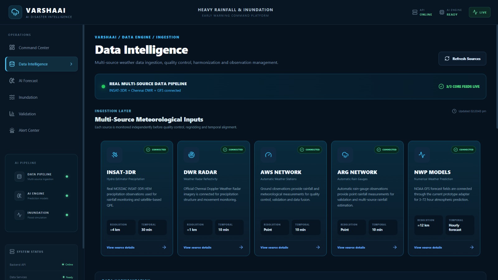
The system is designed to ingest data from multiple meteorological and geographical sources.
Satellite Data
Satellite observations provide wide-area information about atmospheric and cloud conditions. VARSHAAI is designed to support INSAT-based observations and other satellite-derived meteorological information.
Satellite data provides spatial coverage that is difficult to obtain from ground stations alone.
Weather Radar
Weather radar provides high-resolution information about precipitation systems and rainfall structure.
Radar observations are particularly important for short-term rainfall nowcasting because they can capture the movement and evolution of precipitation systems.
AWS/ARG Observations
Automatic Weather Stations and Automatic Rain Gauges provide ground-level observations.
These observations help provide local measurements of:
- Rainfall
- Temperature
- Relative humidity
- Wind
- Pressure
- Other available meteorological variables
Ground observations are useful for validating and correcting remotely sensed information.
Numerical Weather Prediction
NWP models provide forecasts of future atmospheric conditions.
VARSHAAI uses NWP information as an important input for longer forecast horizons and applies machine-learning-based post-processing to improve forecast usefulness.
Data Harmonization
One of the major engineering challenges was that all these sources operate at different spatial and temporal resolutions.
For example:
- Radar can provide observations at very short time intervals.
- Satellite observations may have different revisit and processing intervals.
- AWS/ARG observations are point measurements.
- NWP data generally has a much coarser spatial resolution and longer forecast intervals.
VARSHAAI therefore introduces a common data-harmonization framework.
The preprocessing pipeline performs:
- Data ingestion
- Format standardization
- Missing-data handling
- Quality control
- Spatial regridding
- Temporal alignment
- Resampling
- Common-grid generation
- Feature preparation
The different datasets are transformed into a common representation so that the AI/ML modules can process them together.
Preprocessing and Quality Control
Raw meteorological data cannot be directly passed into an AI model.
VARSHAAI therefore performs several preprocessing operations.
Missing Data Handling
Missing observations are identified and handled using appropriate interpolation, imputation or availability flags depending on the source.
Radar Quality Control
Radar observations can contain noise, ground clutter and other unwanted signals.
Quality-control procedures are applied before radar information is used for prediction.
Spatial Regridding
Datasets with different grid resolutions are transformed into a common spatial grid.
Methods such as:
- Bilinear interpolation
- Inverse Distance Weighting
- Kriging
can be used depending on the dataset and application.
Temporal Alignment
Different sources can provide observations at different time intervals.
VARSHAAI aligns the observations into a common temporal framework so that the AI models can learn relationships between the datasets.
AI/ML Rainfall Nowcasting
The core intelligence of VARSHAAI is the AI/ML forecasting layer.
For short-term forecasting, the system performs rainfall nowcasting for approximately the next 0–3 hours.
The system can use deep-learning architectures such as:
- ConvLSTM
- U-Net
- Optical-flow-assisted deep learning
These models learn spatial and temporal patterns in rainfall evolution.
For example, a sequence of previous radar and meteorological observations can be provided to the model. The model learns how precipitation structures move, grow or decay and generates future rainfall estimates.
The output can be represented as rainfall intensity maps over the target region.
This transforms the system from a simple monitoring dashboard into a predictive platform.
NWP Post-Processing and Bias Correction
Short-term nowcasting is not sufficient for longer prediction horizons.
Therefore, VARSHAAI includes a separate NWP post-processing component.
NWP forecasts can contain systematic biases caused by model resolution, parameterization and local atmospheric conditions.
VARSHAAI uses machine-learning-based correction techniques to learn the relationship between historical NWP predictions and observed rainfall.
Possible models include:
- Gradient Boosting
- Random Forest
- Neural Networks
- CNN-based bias correction
The corrected forecast can then provide improved rainfall information for longer forecast horizons.
This gives VARSHAAI two complementary forecasting capabilities:
0–3 hours: AI-based rainfall nowcasting
3–72 hours: NWP-based forecasting with ML post-processing/correction
Inundation Prediction
Rainfall prediction alone does not tell us exactly where flooding may occur.
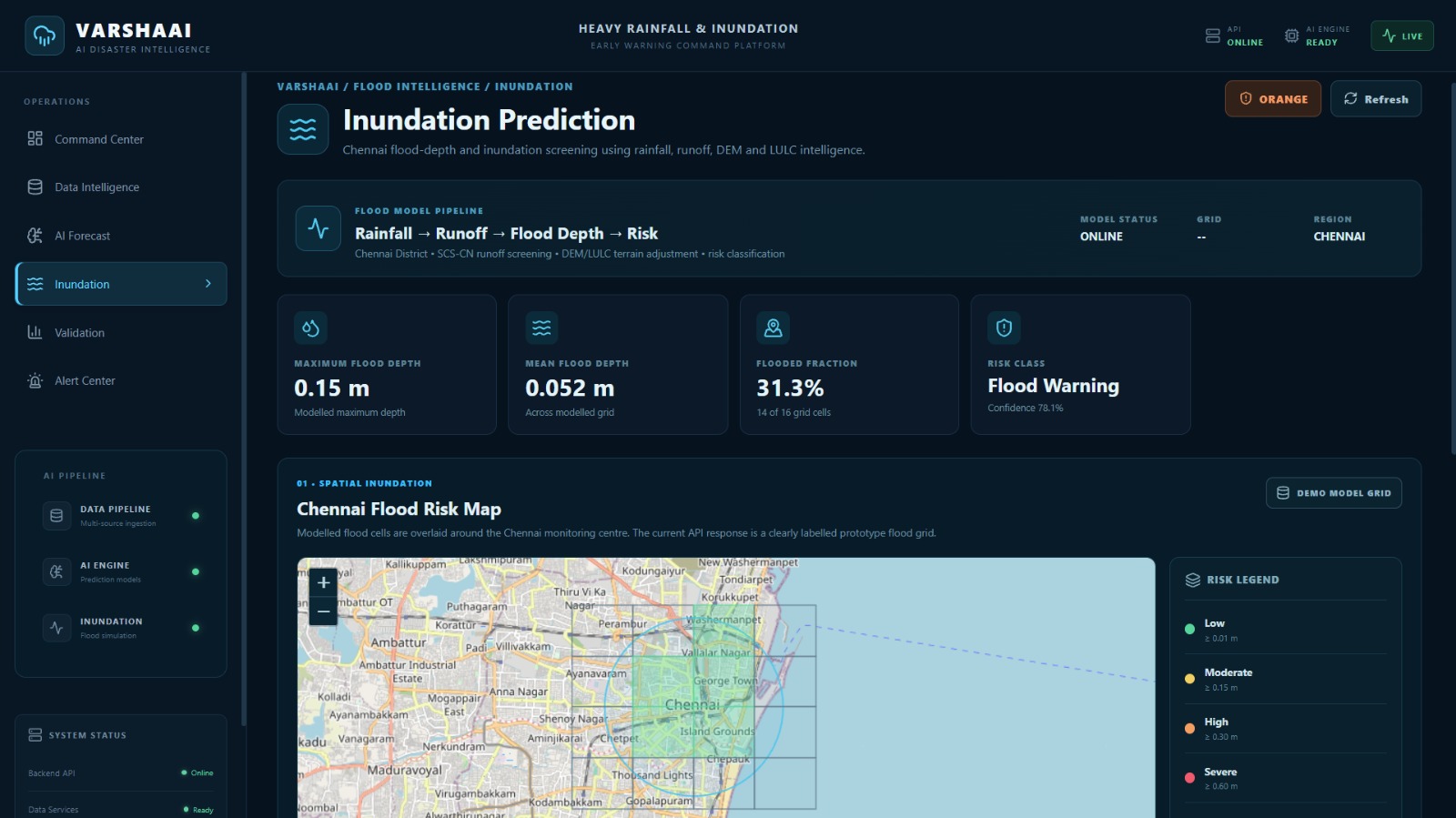
VARSHAAI therefore includes an Inundation/Flood Mapping Module.
The system combines rainfall information with geographical and hydrological factors such as:
- Digital Elevation Model
- Drainage network
- Land-use/Land-cover
- Surface characteristics
- Accumulated rainfall
- Rainfall intensity
- Runoff-related parameters
The system estimates the potential movement and accumulation of water across the terrain.
For screening-level analysis, rainfall-runoff approaches such as the SCS-CN method can be incorporated.
For more detailed hydraulic modelling, frameworks such as HEC-RAS or LISFLOOD-type approaches can be integrated depending on data availability and deployment requirements.
The output can include:
- Flood-risk zones
- Potential inundation extent
- Estimated inundation depth
- High-risk locations
- Spatial flood-risk maps
Risk Classification
VARSHAAI converts continuous weather and inundation information into understandable risk categories.
The system can classify areas according to levels such as:
- Low Risk
- Moderate Risk
- High Risk
- Very High Risk
Risk assessment can consider rainfall intensity, accumulated rainfall, forecast confidence, terrain characteristics and predicted inundation.
This makes the output easier to understand for emergency-response teams and decision-makers.
Validation and Skill Scoring
An AI prediction system must be evaluated against actual observations.
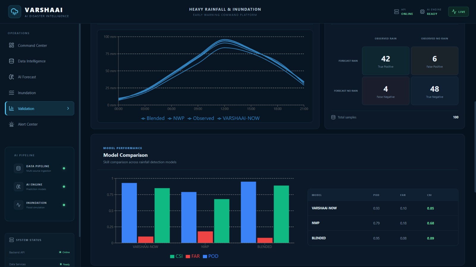
VARSHAAI therefore includes a dedicated validation module.
Historical rainfall events are used to evaluate prediction performance.
The system supports metrics such as:
Probability of Detection (POD)
Measures how effectively the system detects observed events.
False Alarm Ratio (FAR)
Measures the proportion of predicted events that did not occur.
Critical Success Index (CSI)
Evaluates the overall ability to correctly predict events while accounting for misses and false alarms.
RMSE
Measures the magnitude of prediction errors.
MAE
Measures the average absolute difference between predicted and observed values.
The validation layer allows the system to compare predictions with observations and continuously assess model performance.
Early Warning and Alert System
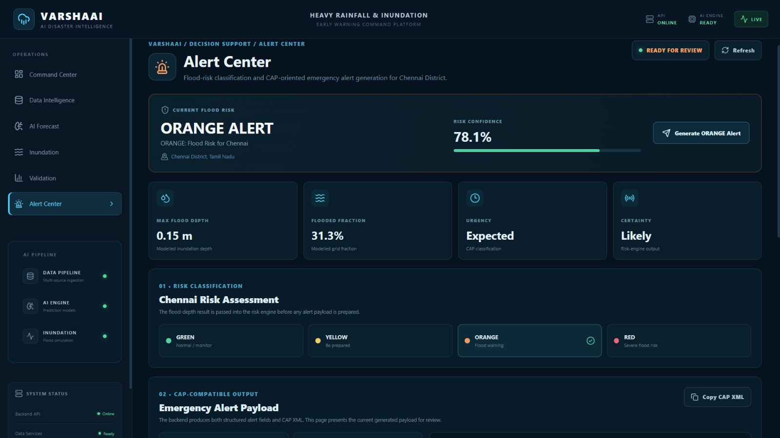
One of the most important outputs of VARSHAAI is the early-warning capability.
When forecast rainfall and inundation indicators cross predefined risk thresholds, the system can generate alerts.
The alert system can provide information such as:
- Location
- Forecast rainfall
- Risk level
- Expected time window
- Inundation probability/risk
- Potentially affected area
- Recommended attention level
The goal is to provide information early enough for authorities to begin preparedness and response activities.
Command Center
All major outputs are brought together in an interactive command-center dashboard.
The frontend is built using:
- React
- Vite
- Leaflet
- React-Leaflet
- Recharts
- Modern CSS
The dashboard provides different functional views for:
- Data Intelligence
- AI Forecast
- Inundation
- Validation
- Alerts
- Interactive Maps
The map interface allows users to visualize geographic risk information instead of relying only on numerical tables.
Charts and indicators help users understand rainfall trends, forecast information and model performance.
Backend Architecture
The backend is implemented using Python and FastAPI.
The backend provides APIs for the major system modules.
The architecture includes endpoints for:
- Health monitoring
- Dashboard information
- Alerts
- Analyst information
- Flood prediction
- Flood risk
- Validation
- Validation summaries
- Data sources
- AI/ML models
The backend acts as the bridge between the data-processing and prediction layers and the frontend command center.
This modular architecture allows individual data-source adapters and prediction modules to be upgraded without redesigning the complete application.
System Architecture
The overall architecture can be represented as:
                    ┌──────────────────────────────┐
                    │        DATA SOURCES          │
                    ├──────────────────────────────┤
                    │ Satellite / INSAT            │
                    │ Weather Radar                │
                    │ AWS / ARG                    │
                    │ NWP Models                    │
                    │ DEM / Drainage / LULC        │
                    │ Historical Events             │
                    └──────────────┬───────────────┘
                                   │
                                   ▼
                    ┌──────────────────────────────┐
                    │     DATA INGESTION LAYER      │
                    │ Source Adapters & Schemas     │
                    └──────────────┬───────────────┘
                                   │
                                   ▼
                    ┌──────────────────────────────┐
                    │ PREPROCESSING & QC PIPELINE   │
                    ├──────────────────────────────┤
                    │ Missing Data Handling         │
                    │ Radar Quality Control         │
                    │ Spatial Regridding            │
                    │ Temporal Alignment            │
                    │ Common Grid Generation        │
                    └──────────────┬───────────────┘
                                   │
                                   ▼
              ┌─────────────────────────────────────────┐
              │             AI / ML ENGINE              │
              ├──────────────────────┬──────────────────┤
              │                      │                  │
              ▼                      ▼                  │
       ┌───────────────┐      ┌────────────────┐       │
       │ 0–3 hr        │      │ 3–72 hr         │       │
       │ Nowcasting    │      │ NWP Correction  │       │
       │ ConvLSTM/U-Net│      │ ML Bias Correct │       │
       └───────┬───────┘      └───────┬────────┘       │
               │                       │                │
               └───────────┬───────────┘                │
                           ▼                            │
                    ┌───────────────┐                  │
                    │ Rainfall      │                  │
                    │ Forecast      │                  │
                    └───────┬───────┘                  │
                            │                           │
                            ▼                           │
                 ┌──────────────────────┐              │
                 │ INUNDATION MODULE    │              │
                 ├──────────────────────┤              │
                 │ DEM                  │              │
                 │ Drainage             │              │
                 │ LULC                 │              │
                 │ Runoff / Hydrology   │              │
                 └──────────┬───────────┘              │
                            │                           │
                            ▼                           │
                 ┌──────────────────────┐              │
                 │ FLOOD RISK & MAPS   │              │
                 │ Extent / Depth       │              │
                 └──────────┬───────────┘              │
                            │                           │
                            ▼                           │
                 ┌──────────────────────┐              │
                 │ VALIDATION MODULE    │              │
                 │ POD / FAR / CSI      │              │
                 │ RMSE / MAE           │              │
                 └──────────┬───────────┘              │
                            │                           │
                            ▼                           │
                 ┌──────────────────────┐              │
                 │ ALERT & DECISION     │              │
                 │ SUPPORT ENGINE       │              │
                 └──────────┬───────────┘              │
                            │                           │
                            ▼                           │
          ┌──────────────────────────────────────────────┐
          │          VARSHAAI COMMAND CENTER             │
          ├──────────────────────────────────────────────┤
          │ Forecasts │ Maps │ Alerts │ Validation       │
          │ Data Intelligence │ Risk Visualization       │
          └──────────────────────────────────────────────┘

Log in or sign up for Devpost to join the conversation.