-
-

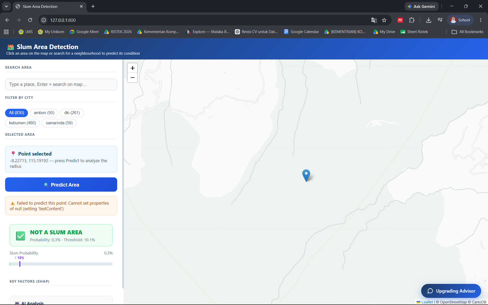
The search result shows that the selected area is classified as a non-slum based on our AI-powered satellite image analysis.
-
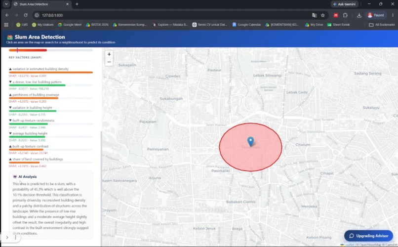
The search result shows that the selected area is classified as a slum based on our AI-powered satellite image analysis and using xAI..
-
Chatbot


UrbanPulse: AI-Powered Slum Intelligence System
Inspiration
Urban settlement growth in Indonesia is happening much faster than official datasets can keep up. While settlements can change significantly within months, official slum data from government agencies is often updated annually or over even longer periods. This creates a data lag that can affect the accuracy of urban planning, budget allocation, and intervention programs. At the same time, identifying slum areas still relies heavily on field surveys, which are costly, time-consuming, and difficult to scale. We saw an opportunity to leverage advances in satellite imagery, machine learning, and generative AI to create a more efficient and accessible approach.
UrbanPulse was inspired by a simple question: How can governments identify potential slum areas faster, understand why those areas are vulnerable, and access relevant knowledge for intervention without waiting for lengthy survey processes? Our goal was to transform satellite imagery into actionable urban intelligence that supports evidence-based decision-making.
What it does
UrbanPulse is an AI-powered decision-support system designed to assist governments in identifying and understanding potential slum areas. The platform uses machine learning models trained on geospatial data to classify areas as slum or non-slum based on observable physical characteristics. By analyzing satellite imagery and urban morphology, the system can identify spatial patterns commonly associated with slum settlements, including:
- High building density
- Irregular settlement structures
- Limited open spaces
- Environmental degradation
- Physical indicators of inadequate urban infrastructure
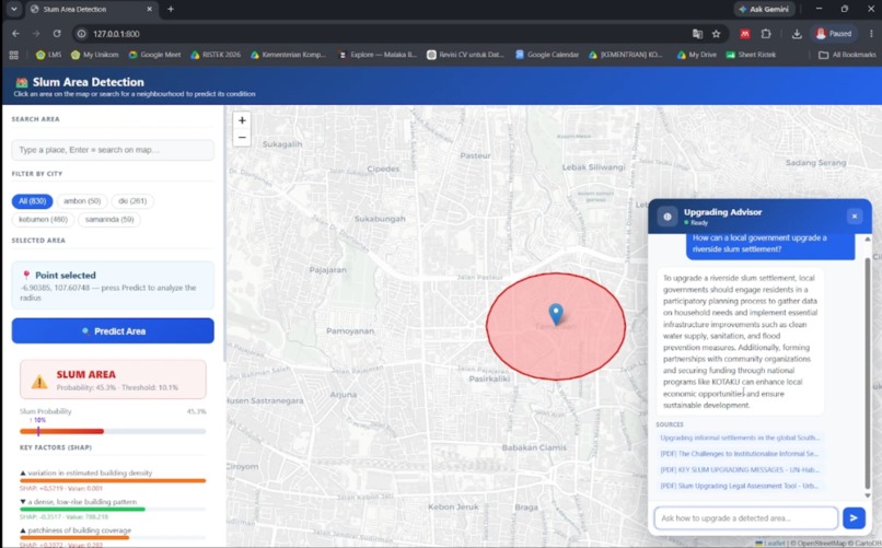
Beyond classification, UrbanPulse provides explainable insights into the spatial factors influencing each prediction. Instead of producing a black-box result, the system highlights the dominant geospatial characteristics associated with the detected area. To complement the limitations of geospatial analysis, UrbanPulse integrates an AI chatbot powered by Retrieval-Augmented Generation (RAG) and web search. While satellite imagery can reveal physical conditions, many aspects of slum management involve additional dimensions such as governance, infrastructure, public services, socioeconomic conditions, regulations, and policy frameworks.
The chatbot enables users to:
- Understand the meaning behind model predictions.
- Explore potential causes and contributing factors.
- Access relevant regulations and policies.
- Learn from best practices and intervention programs.
- Investigate urban development strategies.
- Retrieve contextual information from trusted external sources.
- Support evidence-based planning and decision-making. As a result, UrbanPulse serves not only as a slum detection tool but also as an urban intelligence platform that bridges geospatial analytics with policy knowledge.
How we built it
UrbanPulse combines remote sensing, geospatial analytics, machine learning, explainable AI, and generative AI technologies into a single workflow.
Data Sources
We utilize multiple open-source geospatial datasets, including:
- Sentinel-1 Synthetic Aperture Radar (SAR) imagery
- Sentinel-2 multispectral imagery
- Open Building datasets
- 2.5D urban morphology and elevation-related spatial features These datasets provide complementary information about settlement structure, land cover, building distribution, and environmental conditions.
Machine Learning Pipeline
The collected geospatial data undergoes preprocessing, feature extraction, and integration into a machine learning framework that has been fine-tuned for Indonesian urban contexts. The model learns spatial representations associated with slum and non-slum environments and generates classification outputs for the study area.
Explainable Spatial Analysis
To improve transparency, we incorporate explainability mechanisms that identify the dominant spatial characteristics contributing to each prediction. This allows users to move beyond simple classifications and better understand the physical conditions influencing model decisions.
AI Knowledge Assistant
We developed a conversational AI assistant using Retrieval-Augmented Generation (RAG) combined with web search capabilities. The chatbot uses:
- Model predictions
- Geospatial analysis outputs
- Retrieved knowledge sources
- Current web information to answer questions, provide contextual explanations, and assist policymakers in exploring possible intervention pathways.
Challenges we ran into
One of the biggest challenges was the availability and consistency of slum-related ground truth data. Official datasets are updated at different times and may use varying criteria, making training and validation difficult.
Another challenge involved integrating multiple geospatial datasets with different spatial resolutions, formats, and characteristics. Combining SAR imagery, multispectral imagery, building footprints, and urban morphology features required extensive preprocessing and harmonization. Interpretability was also a significant challenge. While machine learning models can achieve strong predictive performance, decision-makers need to understand the reasoning behind predictions before acting upon them. Finally, we faced the challenge of connecting geospatial analysis with practical policy support. Satellite imagery alone cannot capture every dimension of slum conditions, which motivated the development of the RAG-powered chatbot to provide broader contextual insights.
Accomplishments that we're proud of
- Built an end-to-end urban intelligence platform that combines geospatial analytics, machine learning, explainable AI, and generative AI.
- Demonstrated that potential slum areas can be identified using entirely open-source geospatial datasets.
- Developed a classification framework tailored to Indonesian urban environments.
- Integrated explainable AI techniques to improve transparency and trust in model predictions.
- Created a RAG-powered chatbot capable of retrieving policy, regulatory, planning, and intervention-related knowledge.
- Reduced reliance on costly and time-consuming manual field surveys.
- Established a scalable workflow that can be adapted to other cities and regions.
What we learned
This project reinforced the importance of combining technological innovation with practical decision-making needs. We learned that high model accuracy alone is not enough. Decision-makers require explanations, context, and actionable insights before they can confidently use AI-generated outputs.
We also gained valuable experience in:
- Remote sensing and satellite imagery analysis
- Geospatial data engineering
- Machine learning for spatial classification
- Explainable AI techniques
- Retrieval-Augmented Generation (RAG)
- AI-assisted decision-support systems Most importantly, we learned that effective urban intelligence systems must integrate multiple sources of information rather than relying solely on a single data modality.
What's next for UrbanPulse 2.0
Our vision for UrbanPulse 2.0 is to evolve from a snapshot-based assessment tool into a comprehensive urban monitoring and forecasting platform. Future developments include:
- Integration of higher-resolution satellite imagery.
- Improved explainable AI capabilities for root-cause analysis.
- Predictive models for slum expansion risk assessment.
- Enhanced policy recommendation systems.
- Integration with government planning and monitoring workflows.
- Expansion to additional cities across Indonesia.
- Development of scenario-based planning tools that simulate intervention outcomes before implementation.
Ultimately, we envision UrbanPulse becoming an AI-powered urban intelligence platform that helps governments make faster, smarter, and more data-driven decisions for sustainable urban development.


Log in or sign up for Devpost to join the conversation.