Inspiration
Turning off location on your phone feels like enough. It isn't anymore. A 2026 study (DoxBench, ICLR 2026) tested 13 AI models on 500 everyday photos and found the best ones could place about 1 in 5 within 560 meters of where they were taken, from the pixels alone. Signs, buildings, plants and road markings give you away even when there's no GPS in the file. I wanted a tool that shows people exactly what their photos reveal and then actually fixes it, before they post.
What it does
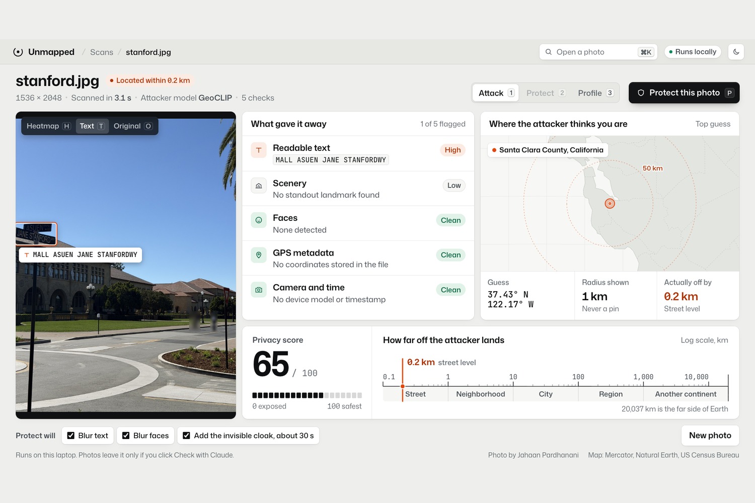
Unmapped attacks your own photo the way a stalker's AI would, then protects it.
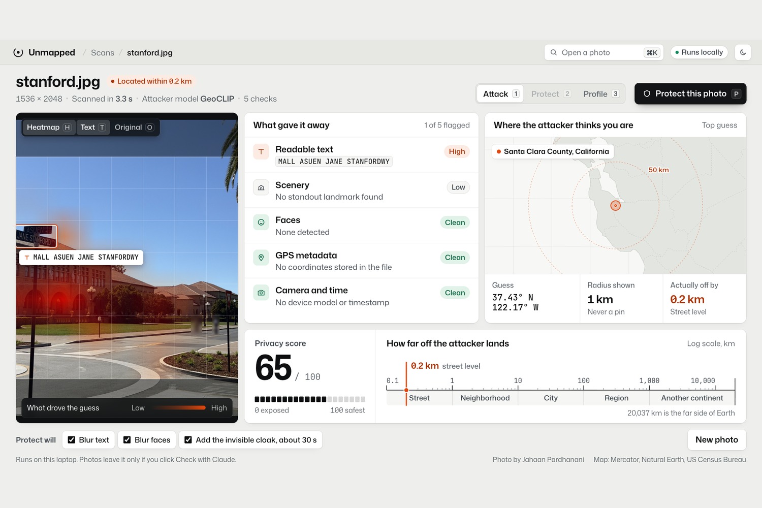
- Attack: it reads hidden GPS and camera metadata, finds readable text and faces, spots scenery clues, guesses the location with an open AI model (GeoCLIP), and shows a heatmap of which parts of the photo gave it away. On my Stanford photo, which has no GPS at all, it got within 0.2 km.
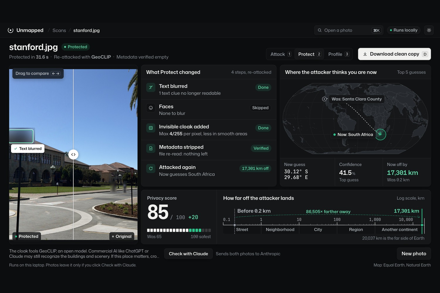
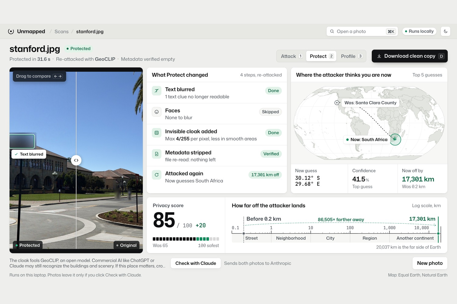
- Protect: it strips the metadata, blurs readable text and faces, and adds an invisible "cloak": tiny pixel changes, at most 4 out of 255 per color, that push the model's guess somewhere else entirely.
- Re-attack: it attacks the saved file again and measures the result. The Stanford photo went from 0.2 km off to about 17,000 km off (the model now guesses South Africa), and it looks the same to you.
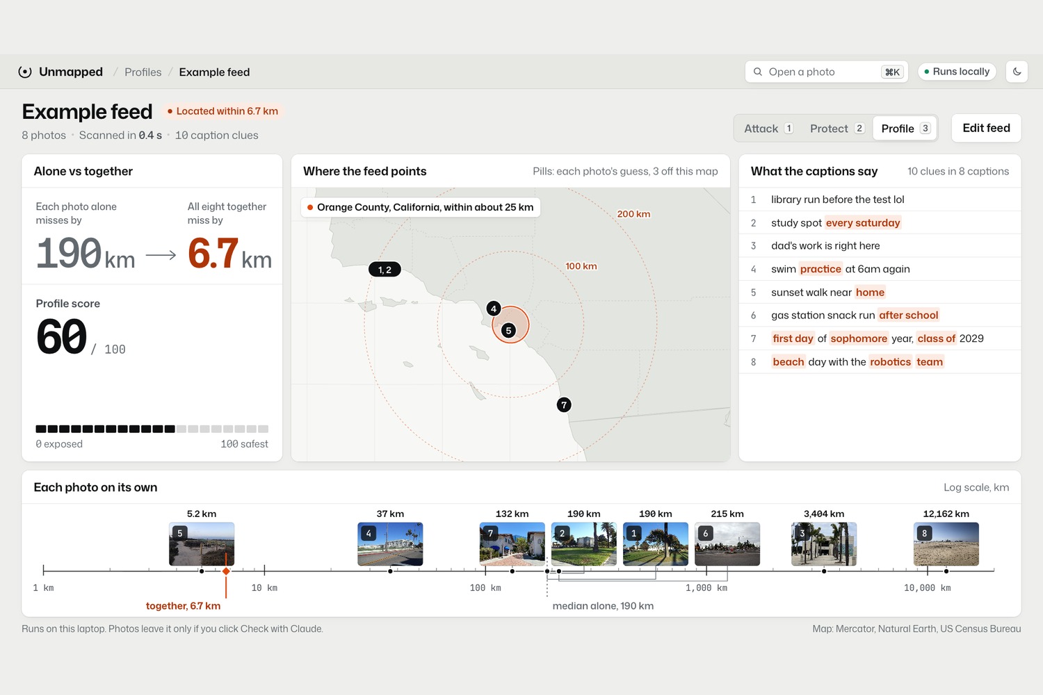
- Profile mode: one photo is usually vague, but a whole feed isn't. On 8 public photos from one area, each photo alone was about 190 km off. Together they narrowed it down to 6.7 km. It also flags risky captions like "first day of sophomore year" or "sunset walk near home".
Everything runs on the laptop. Photos never get uploaded anywhere.
How I built it
- Backend: Python and FastAPI. GeoCLIP (an open model built on OpenAI's CLIP) scores a photo against 100,000 places on Earth.
- The cloak: gradient ascent on the model's expected location error. Each step nudges every pixel slightly in the direction that makes the guess worse, then caps the change so it stays invisible. It runs 100 steps on random crops, so it survives cropping, with a smaller budget in smooth areas like sky.
- Clues: Apple's Vision framework for text and faces (run on overlapping tiles so it catches small signs), CLIP for scenery, and an occlusion heatmap that blurs each patch and measures how much the guess changes.
- Metadata: reads EXIF and GPS from JPEG and iPhone HEIC, saves a fresh copy with only the pixels, then re-reads it to prove nothing is left.
- Frontend: plain HTML, CSS and JavaScript, with d3 drawing the maps from map files stored on the laptop, so there are no map servers and no tracking.
Challenges I ran into
- My first cloak worked perfectly until I cropped the photo by 10%, and then it stopped working completely. It was tuned to one exact framing. I fixed it by training the cloak against a new random crop on every step.
- The next version passed the image-quality numbers but left a faint wavy pattern you could see in clear sky. I added a texture mask that lowers the change limit in smooth areas, and the pattern disappeared.
- Apple's OCR missed the street sign on a full-size photo, so I run it on overlapping tiles instead.
Accomplishments that I'm proud of
- I tested on 30 photos with known locations: every one ended up at least 8,822 km off after protection, even after resizing, JPEG compression and cropping like social media does.
- The changes are invisible: PSNR above 41 dB and SSIM above 0.99 on all 30, and no visible pattern at 100% zoom.
- The privacy result is measured, not assumed. The app attacks the protected file again instead of just saying "you're safe".
What I learned
How adversarial attacks work in practice, why a defense has to be tested against the transformations it will actually face (cropping, compression), and that image-quality numbers can look perfect while a human can still see the change. I also learned how much a set of ordinary photos reveals together compared with one at a time.
What's next for Unmapped
- The cloak is built and measured against open geolocation models. Famous landmarks can still be recognized by the biggest AI models, which is why Unmapped also blurs readable text and shows what's still visible.
- Next: a browser extension and phone app that check a photo right before you post it, portrait-style background blur for selfies, and a cloak trained against several models at once.
- Unmapped supports UN targets 16.2 and 5.2: protecting children, women and girls from abuse and stalking.
