-
-
Predicted High Resolution Landcover Images
-
Barplot showing the distribution of classes from the dataset
-
Three sample performance results

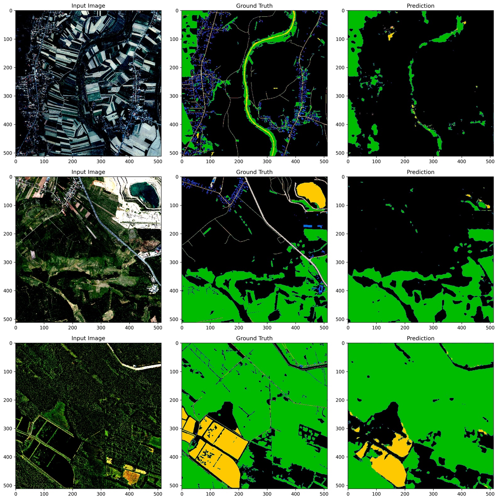
# UNet++: High-Definition Land-Cover Mapping
Inspiration
We started this project because there’s a growing need for accurate, high-resolution maps of land cover. These maps are important for urban planning, environmental monitoring, and studying climate change. Traditional methods often lack in the precision needed for analyzing landscapes. The potential of deep learning, especially the UNet++ model is used to improve land-cover mapping.
What It Does
UNet++ is an advanced version of the UNet model, designed for image segmentation. It enhances the original UNet by adding a nested skip pathway structure. This helps improve accuracy, particularly in complex images.
How We Built It
we build using the following steps: 1.High-resolution Aerial images and their land-cover masks, focusing on five categories such as background, building, woodland, water and road is downloaded from the landcover.ai dataset.Dataset is splitted into training (80%) and validation subset(20%).
2.We developed the UNet++ model with PyTorch, taking use of its hierarchical connections to increase feature representation.
3.We implemented a robust training method that involves data loaders for efficient processing and data augmentation approaches to improve model performance utilizing the cross entropy loss function and Adam optimizer.
4.We evaluated our model's performance using metrics like pixel accuracy and Intersection over Union (IoU).
5.We showed bar-graph indicating the distribution of classes from the dataset and summarize the key performance metrics and visualize predictions against ground truth masks and generate high resolution land cover maps.
Challenges We Faced
Throughout the project, we faced many challenges,they are
1.Some land cover classifications were unrepresented which we corrected using data augmentations methods.
2.Differentiating different land cover types in complicated metropolitan environments was tough, so we iterated on our model and post-processing methods.
3.Managing large amounts of high-resolution images was challenging, which we solved by optimizing our data handling and storage.
What We Learned
Throughout the project,following steps are learned.They are
The advantages of UNet++ over traditional segmentation methods.
The complexities involved in working with high-resolution aerial images.
How to balance model complexity and computational efficiency.
Techniques for handling multi-class segmentation in land-cover mapping.
The importance of data preparation and augmentation for achieving high accuracy.
What's Next
Future improvements could include:
Training on more data or using transfer learning from more advanced models.
Regularly evaluating the model on new validation data to ensure it performs well on unseen images.
Integrating the model with Geographic Information Systems (GIS) for wider applications in environmental analysis and urban planning.

Log in or sign up for Devpost to join the conversation.