The Problem
India has important sources of information about heat, air quality, flooding, heavy rainfall and extreme weather. However, this information is often spread across different government alerts, dashboards, maps, advisories and local reports. The information may be accurate, but it is not always easy for ordinary people to understand or apply to their own location.
When conditions change, people do not usually ask for a technical risk category. They ask practical questions such as, “Is it safe to go outside?”, “Should I change my route?”, “Which areas are affected?”, or “What should I do right now?” Users may have to find the right source, understand unfamiliar terminology, check whether the warning applies to them and compare different updates before making a decision.
This creates a communication gap between official hazard intelligence and real-world action. People may receive a warning but still not know what it means for their specific location, whether the situation is getting worse or which next step makes sense.
The need is becoming more urgent. According to the India Meteorological Department, 2024 was India’s warmest year since nationwide records began in 1901, with the annual mean temperature around 0.65°C above the 1991–2020 average. The IMD also reported that extreme weather events across the country caused approximately 2,400 deaths in 2024, including more than 1,280 deaths linked to lightning and thunderstorms.

Source: India Meteorological Department, Annual Climate Summary 2024
The Idea
I want to build TRINETRA, an AI-powered, multi-hazard intelligence platform for India. TRINETRA would combine official alerts, government advisories, forecast updates and local hazard reports to create a unified, explainable heatmap.
The map would bring together different risk layers, including heat, air quality, flooding, heavy rainfall and extreme weather. Users could view each hazard separately or understand where multiple risks overlap in the same location.
Users could ask questions naturally through voice, such as “What risks are near me?” or “Which hazard is increasing in this area?” TRINETRA would identify the relevant location, show the affected areas on the map and explain the situation in plain language.
The platform would not simply display a risk colour without context. It would show the source, timestamp and relevant evidence behind each update. This would help users understand what is confirmed, what is changing and where uncertainty remains.
Why It Matters

People do not need another warning that they cannot interpret. They need to understand what a warning means for their location and what they should consider doing next.
TRINETRA could make hazard information easier to access, easier to understand and more useful during changing conditions. Instead of requiring users to check multiple dashboards and advisories, it would bring the most relevant information together in one map-based experience.
The platform could also make hazard communication more accessible through voice interaction, simple explanations and future support for regional languages. Its goal is not to replace emergency authorities or guarantee perfect predictions. Its goal is to help people understand risk, uncertainty and possible next steps more clearly.
In the long term, TRINETRA could become a trusted hazard-intelligence layer that connects official information with local conditions. It could help people see where risk is happening, understand how it may develop and make better-informed decisions before a situation becomes more serious.
How I Might Start
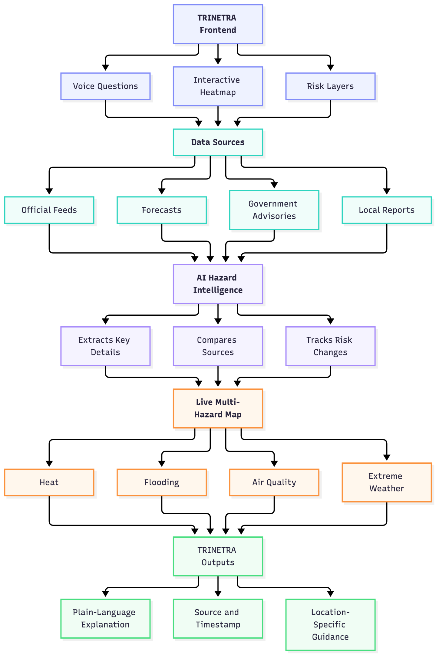
I would begin by building TRINETRA around a unified, multi-hazard heatmap for India. The map would display different risk layers, including heat, air quality, flooding, heavy rainfall and extreme weather, allowing users to view hazards separately or understand where multiple risks overlap.
The first version would connect representative official data sources to the interactive map and a voice-based question flow. Users could ask questions such as, “What risks are near me?” or “Which hazard is increasing in this area?” TRINETRA would show the relevant location, current risk level, affected areas and recent changes through the heatmap.
The AI would interpret official advisories, forecasts and hazard reports, extracting key information such as location, timing, severity and direction of change. It would then explain the information in plain language while showing the source and timestamp behind each update.
A backend service would organise the different hazard layers and compare incoming updates. The frontend would provide the heatmap, voice interaction, explanation page and risk-trajectory view.
The initial goal would be to demonstrate one complete multi-hazard workflow:
A user asks a question, TRINETRA identifies the relevant risks, visualises them on the map, explains how they may change and provides a clear location-specific next step.
The prototype would focus on making the hazard map, voice interaction, AI-powered information synthesis and explainable risk guidance work reliably. More advanced features, such as user-submitted images, community reporting and external actions, could be explored later once the core intelligence system is stable.
UI Proof of Concept
I have attacted an early mobile-first proof-of-concept for TRINETRA. It currently demonstrates the core Home, Map and Ask TRINETRA voice flows, while additional screens for hazard details, risk trajectories, source explanations and weather views are planned for the build phase.
This prototype is intended to communicate the initial user journey and interaction model. During the build phase, I plan to expand and refine the interface into a complete hazard-intelligence experience with interactive risk layers, clearer evidence explanations, changing-risk timelines, voice interaction and location-specific recommendations.
The Canva layout is designed to be explored interactively on a laptop. It is solely a proof of concept.
Built With
- css3
- html5
- javascript
- python
- restapi

Log in or sign up for Devpost to join the conversation.