TrackWise
Central Florida food access, tract by tract.
Challenge: DataKind Beacon – Challenge 2: Food Access & Nutrition Gaps (Central Florida)
About the Project
The Inspiration
Food insecurity is not the same everywhere. Some neighborhoods lack nearby grocery stores or food pantries, others have residents who cannot easily access transportation, and some communities may have low participation in available food-assistance programs.
We were inspired to build TrackWise because food-assistance organizations need more than a map showing where food access is limited. They need to understand why each community faces barriers so they can make better decisions about where to invest resources and what interventions will have the greatest impact.
Food banks, pantries, and SNAP outreach teams often operate with limited staff, vehicles, and funding. Without a detailed, local perspective, it is difficult to determine whether a neighborhood needs a new food distribution location, transportation support, or increased awareness of existing assistance programs.
TrackWise was designed to turn public data into practical, community-focused insights.
What TrackWise Does
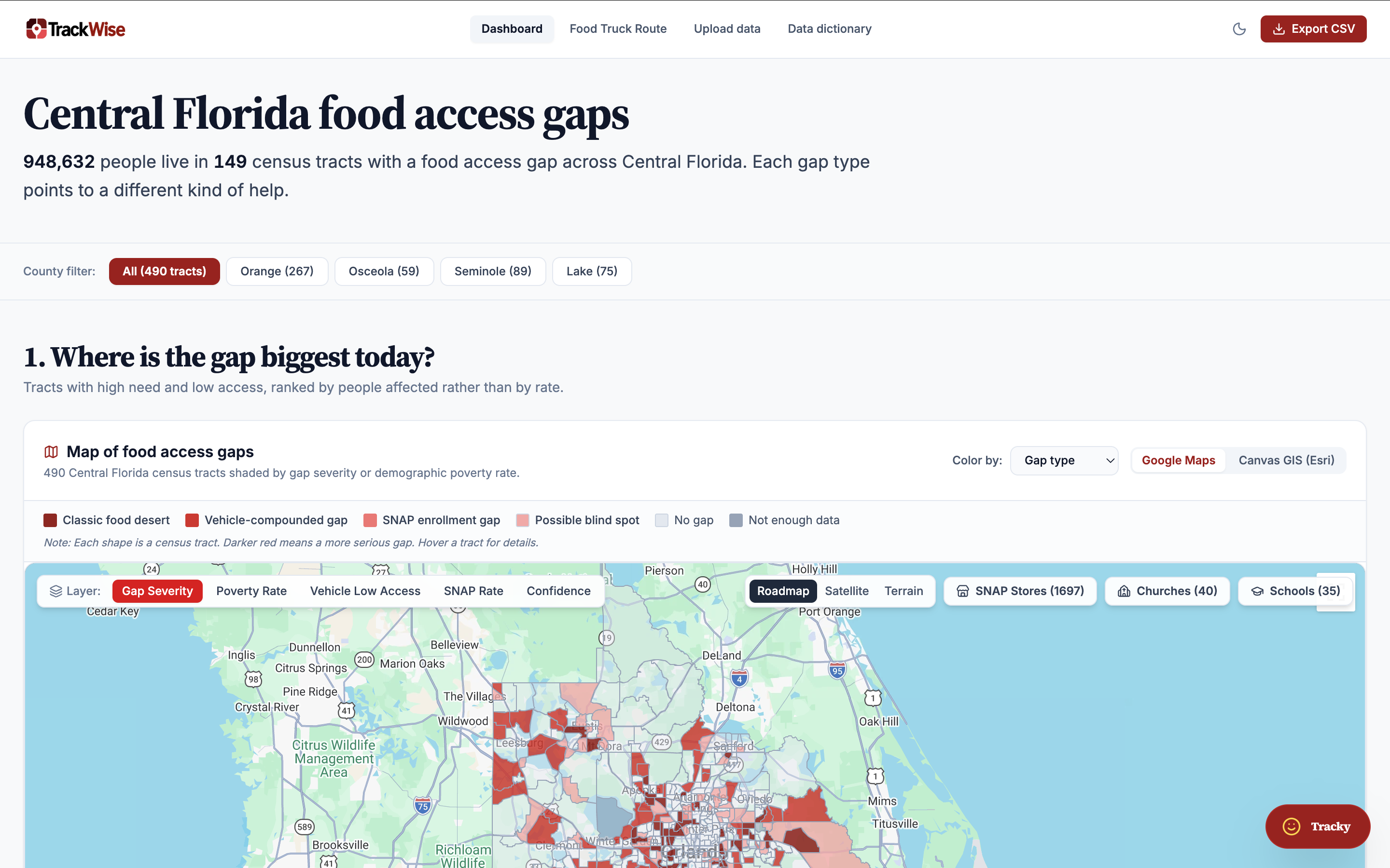
TrackWise shows where Central Florida residents face food-access gaps, what type of gap each census tract has, and how confident the analysis is.
The platform covers 490 census tracts across Orange, Osceola, Seminole, and Lake counties. It transforms publicly available Census and USDA data into an interactive red-scale map, ranked lists, and recommended actions for food-assistance organizations.
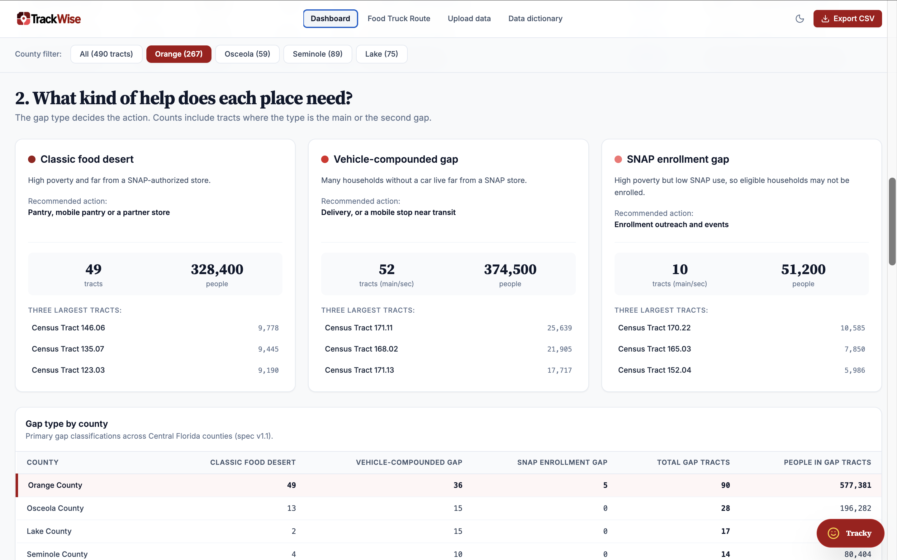
Rather than treating every underserved neighborhood as having the same problem, TrackWise identifies five distinct gap types:
- Classic Food Desert: Areas with limited access to nearby food retailers.
- Vehicle-Compounded Gap: Communities where limited vehicle access makes reaching food retailers more difficult.
- SNAP Enrollment Gap: Areas where SNAP participation indicators suggest opportunities for increased outreach.
- Possible Blind Spot: Areas where data limitations or uncertainty require additional field verification.
- Insufficient Data: Areas without enough reliable information to support a confident classification.
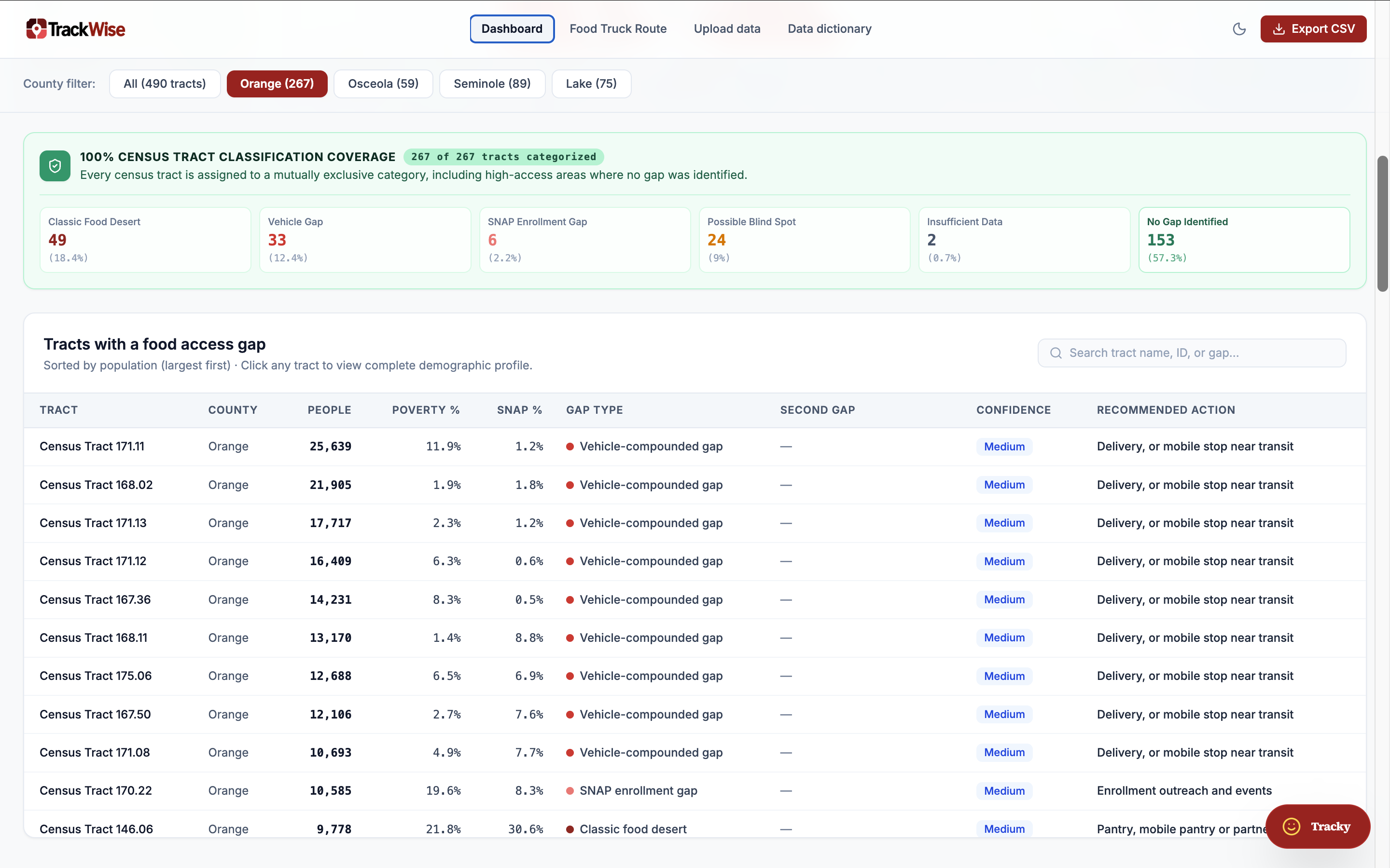
Each census tract receives a confidence level, review tier, and recommended response.
The dashboard answers three essential questions:
- Where are the gaps? Identify communities experiencing food-access challenges.
- What type of gap is it? Understand the underlying barriers affecting each area.
- What don't we know? Highlight uncertainty and identify where additional investigation is needed.
TrackWise also includes a what-if scenario feature that demonstrates how changes in poverty or vehicle access could affect the number of impacted census tracts.
Key Findings
Our analysis revealed several important patterns across Central Florida:
- 149 of 490 census tracts have a food-access gap, representing approximately 948,600 people (34% of the population).
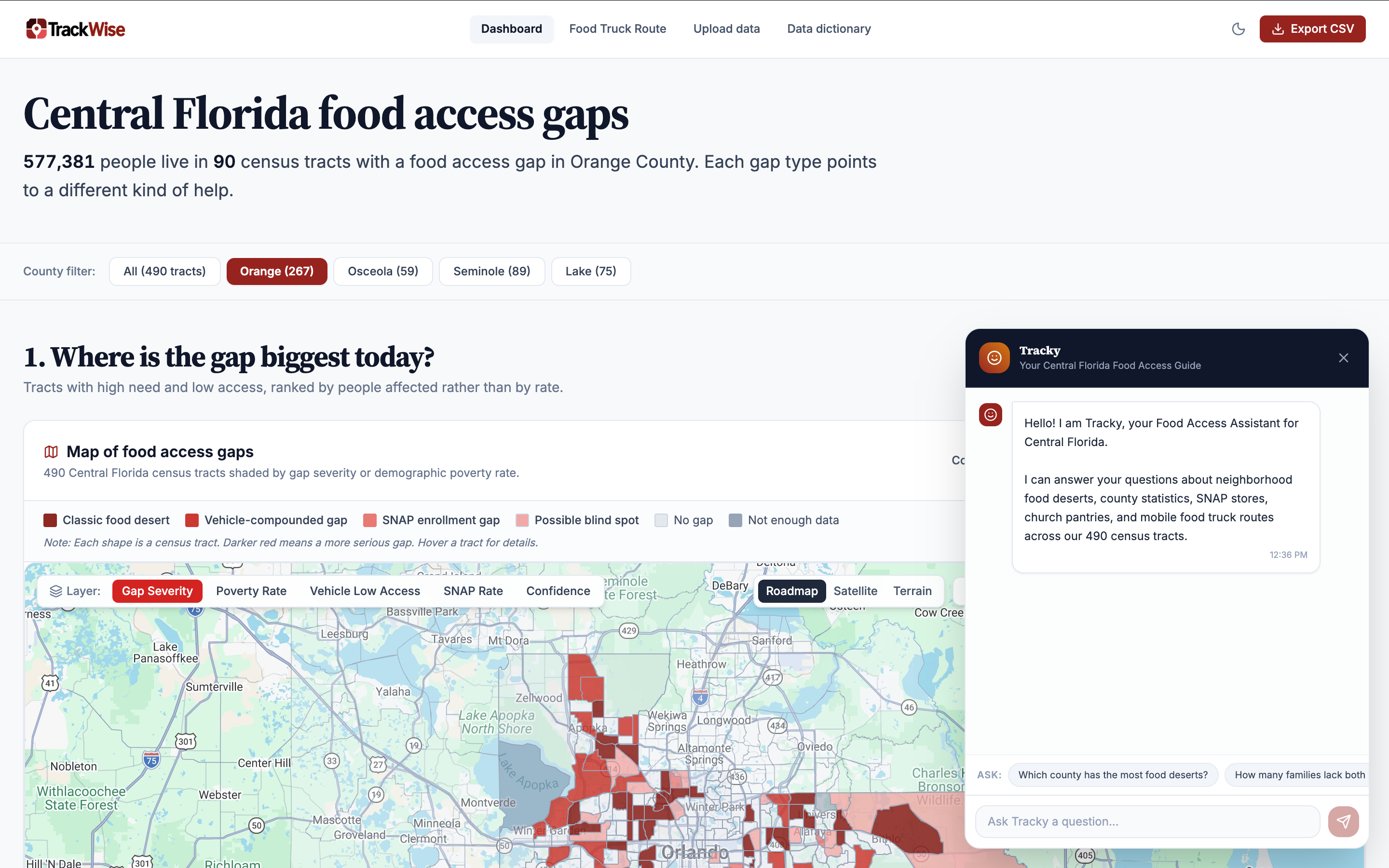
- Orange County accounts for 90 of these tracts and approximately 577,400 affected residents.
- Vehicle access is the most widespread barrier, affecting 108 tracts and approximately 697,700 people.
- 68 classic food deserts were identified, including 49 in Orange County.
- 58 possible blind spots, representing approximately 315,800 people, require field verification before resources are committed.
- A simulated 10% increase in poverty would affect approximately 10 additional tracts and 47,900 more residents.
These findings demonstrate why food-access planning must consider transportation, economic conditions, and data reliability—not just the physical distance to a grocery store.
How We Built It
We designed TrackWise as a data-processing and visualization platform that transforms multiple public datasets into actionable information.
The workflow begins with an upload portal where an administrator can load public CSV datasets, including:
- Census ACS S0101 – Age and population characteristics.
- Census ACS S1701 – Poverty status.
- Census ACS S2201 – SNAP participation.
- Census ACS S1901 – Income distribution.
- USDA SNAP Retailer Access Map.
- USDA SNAP retailer locations.
Once uploaded, a Firebase Cloud Function validates the files, executes the food-access gap classification engine, and stores versioned analysis results in Google BigQuery.
The dashboard, Looker Studio reports, and a read-only Data API consume the processed results from BigQuery. This architecture provides a centralized data source and allows other applications to access the analysis without duplicating the processing logic.
Technology Stack
- Data & Analytics: Google BigQuery, Looker Studio.
- Backend & Infrastructure: Firebase Authentication, Firestore, Cloud Storage, Hosting, and Cloud Functions.
- Frontend: React, Node.js, and D3.js.
- AI Assistance: Google AI Studio.
Challenges We Faced
Building TrackWise involved several important data and technical challenges.
1. Missing Transportation Data
CDC PLACES transportation data was blank for Central Florida. To address this limitation, we used the USDA indicator measuring households without a vehicle that are far from a SNAP retailer as a substitute. This allowed us to incorporate transportation barriers while acknowledging that the substitute does not capture every aspect of transportation access.
2. Uncertainty in Census Estimates
Census estimates can have wide margins of error, particularly in smaller census tracts. We did not want to present uncertain results as definitive facts. Instead, we incorporated confidence levels, review tiers, and a dedicated "What We Don't Know" view to make uncertainty visible and encourage additional investigation.
3. Large Source Files
Some source datasets are as large as 39 MB. Processing all records would introduce unnecessary overhead. We addressed this by filtering the source files to the four target counties before running the analysis, improving processing efficiency and keeping the platform focused on its intended geographic scope.
4. Turning Data into Action
Another major challenge was translating multiple indicators into meaningful recommendations. A single score cannot explain every community's needs. We addressed this by creating distinct gap classifications and associating each classification with a recommended response.
What We Learned
Developing TrackWise reinforced several important lessons:
- Public data becomes more valuable when it is translated into understandable, actionable information.
- Food insecurity and food access are multidimensional problems that require more than one indicator.
- Data quality and uncertainty should be communicated transparently rather than hidden.
- Geographic granularity matters: county-level statistics can overlook important differences between neighboring communities.
- Technology should support decision-making, not replace local knowledge and field verification.
Most importantly, we learned that identifying a problem is only the first step. The real value comes from helping organizations understand what action they can take next.
What's Next?
We see TrackWise as a foundation that can continue evolving into a more comprehensive decision-support platform.
Our next development priorities include:
- Adding ZIP code and city information for each census tract.
- Applying the client's review tiers and prioritization criteria.
- Creating a "Where to Act First" Top 10 list to highlight the highest-priority communities.
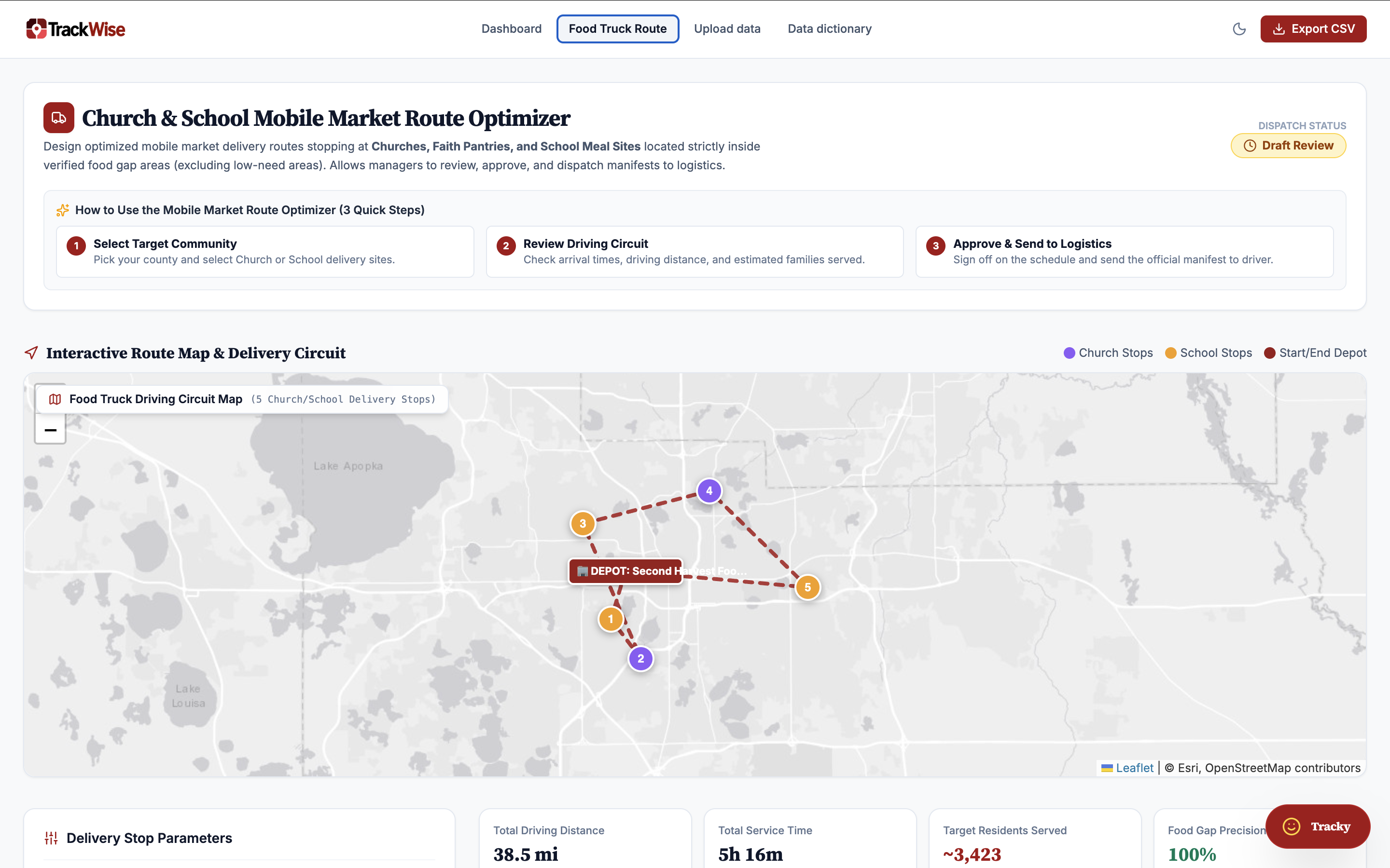
- Replacing straight-line distance calculations with actual driving and public transportation travel times.
- Integrating Gemini to generate plain-language summaries explaining each census tract's conditions, challenges, and recommended interventions.
Our Vision
Our goal is to help food-assistance organizations move from simply identifying food-access gaps to understanding and addressing them.
By combining public data, transparent analysis, and actionable recommendations, TrackWise aims to help Central Florida communities make better-informed decisions about food access and resource allocation.
TrackWise: Better data. Clearer priorities. Stronger communities.
Built With
- cloud-functions)
- cloud-storage
- d3.js
- firebase-(authentication
- firestore
- google-ai-studio
- google-bigquery
- hosting
- looker-studio
- node.js
- react


