The WaterBoard
Keeping heads above water.
Inspiration
During our brainstorming session, several teammates shared their personal experiences with flooding. This inspired us to explore State Farm's disaster-response challenge and consider how technology could improve emergency coordination.
Our goal was to build more than a flood-monitoring dashboard. We wanted a platform that could simulate disasters, prioritize emergency requests, and coordinate rescue teams in real time.
That idea became The WaterBoard, a flood-response simulation and emergency dispatch platform inspired by Hurricane Harvey.
What it does
The WaterBoard combines historical flood data with simulated emergency requests to demonstrate how responders can coordinate rescues during a disaster.
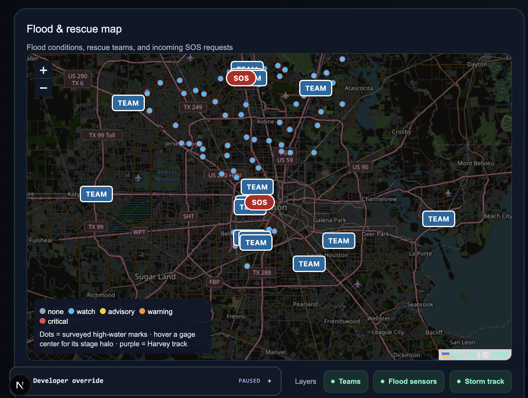
Flood Monitoring: Uses historical USGS river-gauge measurements, high-water marks, and Hurricane Harvey storm data to calculate simulated flood-threat scores (0–100). Locations are categorized as Watch, Advisory, Warning, or Critical.
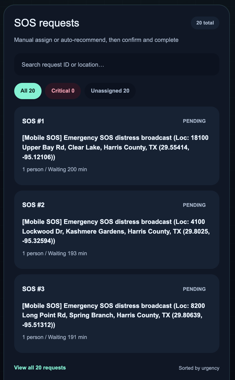
SOS Requests: Users submit emergency requests through a mobile-friendly interface, sharing their GPS location, group size, situation, and assistance needs.
Rescue Prioritization: Requests receive weighted priority scores based on medical emergencies, stranded individuals, transportation needs, and the number of people affected.
Intelligent Dispatch: The system recommends nearby available rescue teams based on distance and capabilities. Dispatchers can assign teams, monitor their status, and mark rescues as completed.
Real-Time Synchronization: SpacetimeDB synchronizes flood conditions, SOS requests, and rescue assignments across connected devices without requiring manual refreshes.
Our Storm Drill mode also generates simulated SOS requests during the Hurricane Harvey replay to demonstrate how the system handles increasing demand.
How we built it
We began by researching historical flood data, designing our architecture, and dividing development across multiple Git branches.
Our technology stack includes:
- SpacetimeDB: Our primary backend, containing 11 tables and transactional reducers for threat scoring, SOS prioritization, and dispatch. Real-time subscriptions keep connected users synchronized.
- Historical Data: USGS water-level measurements from four Houston-area bayous, 365 high-water marks, and 141 Hurricane Harvey storm-track observations. We cleaned and simplified these datasets before importing them.
- Frontend: Next.js 15, React 18, Tailwind CSS 4, and Leaflet for the interactive flood map and emergency dashboard.
- Mobile SOS: An installable Progressive Web App (PWA) that captures GPS coordinates and sends emergency requests.
- AI Simulation: Gemini 2.5 Flash through OpenRouter generates synthetic SOS messages to stress-test our dispatch system, with predefined fallback messages.
- Deployment: Railway hosts our frontend, while SpacetimeDB Maincloud hosts the database.
We used ChatGPT and Gemini for research, brainstorming, and architectural planning, while Cursor AI and OpenAI Codex assisted with application development.
Challenges we ran into
Our biggest challenge was defining a realistic scope. We initially considered building a flood-prediction system but realized that accurate forecasting would require more specialized data and modeling. Instead, we focused on historical simulation and emergency-response coordination.
Learning SpacetimeDB and TypeScript was another challenge, especially understanding reducers, schemas, and real-time subscriptions.
We also had to clean historical datasets and coordinate development across multiple teammates and branches.
Accomplishments that we're proud of
We're proud of turning a broad idea into a working prototype within the limited time of a hackathon.
Our biggest achievements include:
- Building a real-time flood-response and rescue coordination platform.
- Integrating historical Hurricane Harvey data into an interactive simulation.
- Implementing automated SOS prioritization and rescue-team recommendations.
- Using SpacetimeDB as our primary backend.
- Connecting desktop and mobile experiences through shared real-time data.
What we learned
We learned how to use SpacetimeDB as both a database and backend, including transactional reducers and real-time subscriptions.
We also gained experience cleaning real-world environmental datasets, designing prioritization algorithms, and coordinating development across multiple branches.
Most importantly, we learned how to turn an ambitious concept into a focused, achievable application.
What's next for The WaterBoard
We hope to expand The WaterBoard with:
- Administrative Controls: Manage monitored regions, emergency policies, rescue teams, shelters, and database access.
- Additional Disasters: Support hurricanes, wildfires, tornadoes, and other emergencies.
- Improved Dispatch: Incorporate terrain elevation, road closures, travel times, and more advanced resource-allocation algorithms.
- Scalability: Strengthen authentication, reliability, and performance for larger simulations and more concurrent users.
Our long-term vision is to explore how real-time data and intelligent coordination can help communities respond more effectively to natural disasters.
Built With
- javascript
- react
- spacetime
- typescript


